Eyehike Gallery

Welcome to the Eyehike photo gallery

Home / Fire Lane 12 Photos OR /

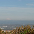
A wider angle of view showing Mt. St. Helens on the left and Mt. Adams on the right, behind the Portland industrial area taken from near the junction of the BPA Road and Fire Lane 13.

aaf.jpg A wider angle of view showing Mt. Adams behind the Portland industrial area taken from near the junction of the BPA Road and Fire Lane 13.ThumbnailsThe new Sauvie Island Bridge taken from near the junction of the BPA Road and Fire Lane 13.A wider angle of view showing Mt. Adams behind the Portland industrial area taken from near the junction of the BPA Road and Fire Lane 13.ThumbnailsThe new Sauvie Island Bridge taken from near the junction of the BPA Road and Fire Lane 13.A wider angle of view showing Mt. Adams behind the Portland industrial area taken from near the junction of the BPA Road and Fire Lane 13.ThumbnailsThe new Sauvie Island Bridge taken from near the junction of the BPA Road and Fire Lane 13.A wider angle of view showing Mt. Adams behind the Portland industrial area taken from near the junction of the BPA Road and Fire Lane 13.ThumbnailsThe new Sauvie Island Bridge taken from near the junction of the BPA Road and Fire Lane 13.A wider angle of view showing Mt. Adams behind the Portland industrial area taken from near the junction of the BPA Road and Fire Lane 13.ThumbnailsThe new Sauvie Island Bridge taken from near the junction of the BPA Road and Fire Lane 13.A wider angle of view showing Mt. Adams behind the Portland industrial area taken from near the junction of the BPA Road and Fire Lane 13.ThumbnailsThe new Sauvie Island Bridge taken from near the junction of the BPA Road and Fire Lane 13.

aaf

Author
Steve Jones
Visits
1287
Rating score
no rating
Rate this photo