Bald Mountain, OR
Vicinity Location:
The trailhead is about 40 miles east of Portland, Oregon in the Mt. Hood National Forest.
Directions:
From Portland take I-84 East to the Wood Village, exit (16A). Head south and turn left onto NE Burnside Rd. Heading East, Burnside will merge into Highway 26.
Follow Hwy 26 for 26.8 miles to Zigzag. When you drive past Welches, you are getting close to Lolo Pass Road. East Lolo Pass Road is just after the Hoodland Fire Station and Salmon River Road, which are both on the right and the Zigzag Mountain Store on the left. Turn left onto E. Lolo Pass Road and follow the twisty paved road for 10.6 miles.
At Lolo Pass, drive past where the PCT crosses Forest Road 18 (Lolo Pass Road), turn right onto Forest Road 1810 and drive about 100 feet to find the small parking area. Many times the parking lot will be full and you’ll need to park along one of the forest roads.
A Northwest Forest Pass is required to park here and the permit is normally enforced May 15 through October 15.
An outhouse is available at the trailhead.
Length and Elevation:
Elevation at the trailhead is 3,480 feet. Total distance is 7.9 miles. Elevation at Bald Mountain is 4,567 feet, Ascent 1,360 feet and descent 263 feet to Bald Mountain. Total ascent is 1,700 feet and total descent is 1,700 feet.
Trail:
Pacific Crest Trail #200, Timberline Trail #600 with connections to other trails.
Trail Maps:
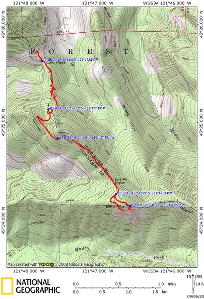
Topo Map, Download Garmin .gpx file, Open Garmin .gpx file
Review: June 26, 2020
This is part of the Pacific Crest Trail and is accessed from Lolo Pass.
If you want a view of Mt. Hood from the beginning of your hike, take the PCT north and you will come out to the powerlines. The trees have been cleared for the power corridor so there is a nice view of Mt. Hood thourh the powerlines are in the foreground. Also, when the beargrass is blooming this area has a really nice display.
For the hike to Bald Mountain, look for the trailhead were the Pacific Crest Trail crosses Lolo Pass Road. Walk south climbing very gently as the trail passes out of the forest and into a partially open meadow that is filled with rhododendrons along the first 0.25 mile. The rhododendrons usually boom in late June and put on a spectacular show along the lower portion of the trail. I think it is one of the best displays of wild rhododendrons in the Pacific Northwest.
This first 0.25 mile of the trail is mostly level and hard-packed dirt on the first section of the trail. The trail climbs a bit and enters a forest of second growth hemlocks and grand fir with a few old growth trees mixed in.
The undergrowth changes from mostly rhododendrons to a mix of rhododendrons and huckleberries. This section of the trail is still a very nice dirt packed trail. The trail enters switchbacks which lead up a spine of Mt. Hood. The higher you climb the thinner the soil and the rockier the trail becomes. Several switchbacks get close to a seasonal stream rushing down a gully in the ridge. As you climb higher the sounds of the stream diminish until you climb above a marshy area which is the source of the stream. If you look you can see a small pond through the trees below the trail.
Climb several more switchbacks and at the last switchback keep an eye out to the north for view of Mt. Adams through the trees. You know you’ve gone too far when you cross a little saddle and start gently descending. Here the trail again turns to lovely dirt trail carpeted with fir needles as it wanders through an old second growth forest. It is a shady canopy of hemlock and grand fir trees.
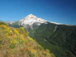
Continue along a mostly level trail and about 0.25 mile you come out to an opening above a mountain meadow which has a jaw-dropping view of Mt. Hood on a clear day. There are also nice wildflowers along the sunny patches in the trail. Reenter the forest on the fir needle covered trail and continue on a mostly level path along the spine of Mt. Hood.
At the junction of the Pacific Crest Trail and the Top Spur Trail #785 continue off to the left, uphill, to the next trail junction which is in about 100 feet. There is a small campsite and the wilderness permit box where you fill out a wilderness permit.
At the 4-way trail junction, go straight, past the wilderness permit box, and take the Timberline Trail #600, Muddy Fork. There is also a Mt. Hood Wilderness sign on a nearby tree. This trail leads gently uphill about 500 feet to a user trail on the left heading uphill. This is an unsigned junction for Bald Mountain. The trail is seldom maintained so expect some deadfall in the trail.
At the top of the trail walk out to the edge of Bald Mountain to a fantastic view of Mt. Hood across the valley of the Sandy
River. There is also a small campsite just in the trees back from the edge but there is no nearby water. Wildflowers bloom in the mountain meadow below the summit. There is goldenrod, paintbrush, columbine, and paintbrush just to name a few. There is also a faint user trail going off to the right but it doesn’t really lead anywhere. Looking down you can see the Timberline Trail below as it heads to the Sandy River.
On the way back, turn left when you reach the Timberline trail and walk about 0.3 mile gently uphill, round a corner to where Mt. Hood majestically comes into view. This is another jaw-dropping view of Mt. Hood across the valley and should not be missed. On a clear day you will be gawking at the view and when you’ve had your fill, return back down the Timberline Trail then the PCT and back to the trailhead.
Enjoy the photos!!
Gallery Pics
Switchback Steve