Cast Lake Trail, OR
Vicinity Location: Mt. Hood National Forest
Location: The trailhead is about 42 miles southeast of Portland, Oregon in the Mt. Hood National Forest.
Directions:
From Portland take I-84 East to the Wood Village, exit (16A). Head south and turn left onto NE Burnside Rd. Heading east, Burnside will merge into Highway 26.
Follow Hwy 26 for 26.8 miles to Zigzag. When you drive past Welches, you are getting close to Lolo Pass Road. East Lolo Pass Road is just after the Hoodland Fire Station and Salmon River Road, which are both on the right and the Zigzag Mountain Store on the left. Turn left onto E. Lolo Pass Road and follow the twisty paved road. At 4 miles, the road enters the Mount Hood National Forest and it turns into road 18. At 4.2 miles turn right onto paved Forest Road 1825. , just a little past the end of the road maintenance sign. Turn right and cross over the Sandy River and drive 1.1 miles. Turn right on road 380
There is a sign that directs you towards the Riley horse camp so you turn right at the sign and you will soon drive past the Horseshoe Ridge Trailhead, which is on the right.
Drive into the horse camp and drive through the horse camp and circle around on the paved loop to come to the cast Creek Trailhead, which is about midway along the loop. There is a nice parking area just after the trailhead and there are bathrooms nearby.
Length and Elevation:
The total ascent to East Zigzag Peak is 3,187 feet and descent of 448 the elevation of the peak is 4,960 feet and distance of 6.17 miles from the trailhead. Total roundtrip elevation gain 4,500 feet and loss of 4,500 feet distance of 16 miles.
Trail:
Cast Creek Trail #773, Zigzag Mountain Trail #775, #796 Cast Lake Trail, Horseshoe Ridge Trail #774.
There is at least one geocache for this trail at: N 45° 22.504 W 121° 49.520 Info at Geocaching.com.
Trail Maps:
Topo Map, Download Garmin .gpx file
Review: 6/12/2016
Near the Cast Ridge Trailhead is a nice sign here that says lahar is an Indonesian word that means of mud and debris flow on the slope of volcano. Lahar flowed here to create this area called Oldmaid Flat. The sediment rich sand and gravel drains fast so it acts more like an alpine setting. The majority of the trees here are Lodgepole pine.
This same soil seems to be good for mushrooms because there are signs talking about needing mushroom permits and gathering limits.
You soon reach a T-junction on the trail and you turn right onto the Cast Creek Trail and go gently downhill for a short bit. You soon hear the sounds of Lost Creek. The forest has an understory of rhododendrons, ferns, huckleberry bushes, vine maple, salal, and thimbleberries.
Soon the trail starts climbing past trees with moss wrapping the branches and dangling from the branches. Sounds of the creek are lost as the trail climbs up the hillside through a series of switchbacks and then continues to gently climb along the side of the ridge through the shady forest. Continuing along the side of the ridge you cross a nice little bridge over a branch of Lost Creek.
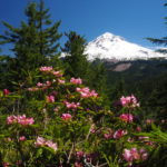
After climbing for about two and a half miles to the top of the ridge and then switchback as you climb up the ridgeline. This area has a lot of nice rhododendrons that bloom in the late spring and there is also beargrass, Oregon grape, salal, and vine maple.
At about 2.5 miles from the trailhead and about 3,500 feet in elevation, the trail actually drops down a bit to follow the ridgeline. The trees are a little thinner here and there are a few glimpses of the ridgeline to the west.
Over the next half mile Trail drops down about a hundred and fifty feet following the top of the ridgeline. From there, rise sharply again on switchbacks going back and forth across the face of the ridge to regain all the lost elevation.
At about the 4,500 foot level and 5 miles in from the trailhead there’s a nice patch of rhododendrons blooming in the spring and then off to the left catch glimpses of Mount Hood through the trees. The trees finally thin out on the ridgetop and there are nearly unobstructed views of Mt. Hood. After about 5 miles walk near the cliff edge for some unobstructed views of all four peaks Mount St. Helens, Mount Rainier, Mount Adams, and Mount Hood. From here the trail drops down a bit to a junction at about five and a half miles into the hike where Cast Lake Trail ends. I like the view from the nearby peak so turn left here and climb up to East Zigzag peak for a short side trip.
Just before the summit is a campsite where unfortunately people have left their trash behind them. They can carry it in but they can’t seem to carry it out. Just past the little campsite there’s a little trail that goes off to the left and you’ll follow that up to the summit of East Zigzag peak. This is a great place to stop for a little snack and take a break. Be sure to walk over the top of the summit and drop down about thirty feet off the summit where there are some more fantastic views of Mount Hood.
Return back to the junction of the Cast Creek Trail and turn left on Zigzag Mountain Trail #775, heading towards Cast Lake. Walk about .1 mile and turn right onto Cast Lake Trail #796. Going to the lake you will soon be climbing a fairly steep hill, then dropping down to Cast Lake. Look for the campsite sign on the way down, turn right, and walk all the way around Cast Lake. There are a couple of places to enjoy the water on the east side of the lake where there is a rocky little place to soak your feet or go swimming. On the west side there is a grassy area but you’ll need something to sit on as the grass and moss are quite wet and wick the water up through the ground. This is the most open area of shoreline for a well-deserved break before continuing back towards Zigzag Mountain Trail.
On the southwest side of Cast Lake you will need to do a bit of cautious scouting to find the trail where it passes through a couple of marshy areas. Return back to the Zigzag Mountain Trail and turn right. You’ll soon pass through a muddy area that dries out later in the summer.
After just under .2 mile turn right to stay on the Zigzag Mountain Trail. From here go up the side of a Zigzag Mountain and climb up to just below the summit of Zigzag Mountain then starts losing elevation. There might be a scramble up to the top but I could not find it.
Follow a generally level section which gently falls and rises until you have a short steep climb back up to the top of the ridge. Just a bit farther you have great views and soon Mt. Hood comes into view behind you as you pass through a shrubby meadow with more nice Mountain views. These are the last views of Mt. Hood until near the end of the hike. Continue down the Horseshoe Ridge Trail for a couple miles and then come out at a trailhead sign on an abandoned road. Follow the road about 50 feet and you’ll see a path going downhill through the brush which will soon open out onto the obvious Trail.
Switchback down the hillside and eventually travel down a long straight stretch which drops down into the valley where the undergrowth changes to ferns and and the soil becomes sandy. Continue walking to the stream crossing where there is a surprise because in 2016 the bridge is broken in two with half on either side. Wading the stream in June found it to be moving quickly and about thigh deep.
In about another quarter mile you’ll enter Riley Campground. You have to pass through this and head to the right to get back to the Riley Creek Horse Campground. I missed the trail and walked to the paved road, turned right, and walked to the cutoff for the horse camp.
Enjoy the photos!
Switchback Steve