Cinnamon-Toutle Loop, WA
Notice: 6/1/2023 – Portions of the #204 Cinnamon Trail, #238 Toutle Trail, #242A Kalama Falls Trail, which depart from the horse camp trailhead, remain closed. To view the map of the remaining closure area, click here.
Vicinity Location: The trailhead is about 47 miles northeast of Portland, Oregon in the Mt. St. Helens National Monument.
Directions:
From Portland, OR, take I-205 north to exit 30b to Battle Ground. Move over to the middle or left lane and proceed north on SR503 for about 10 miles to Battle Ground. Continue north on SR503 past Chelatchie Prairie and Amboy. At the junction of Lewis River Road and SR503, turn right and continue on SR503 past Cougar. Make a left turn on to FR 81.
Directions:
From Seattle take I-5 south and exit I-5 at exit 21 to State Route 503 at Woodland, WA. Drive 26.5 miles, passing through through Cougar, Washington, to Forest Road 81.
Take FR81 to go to the Kalama horse camp. At the big sets of signs turn right again and drive down the paved road about a 0.1 mile to a spot that says trailhead parking only.
There is a restroom at the trailhead.
Length and Elevation:
Total distance is 12.4 miles. Trailhead elevation is 2,200 feet. Highest point is 3,790 feet. Lowest point is 1,992 feet. Total elevation change is 3,300 feet gain and 3,300 feet loss.
Trails:
Cinnamon Trail #204, Toutle Trail #238 and with connections to Butte Camp Trail #238A, and Fossil Trail #242.
There are no geocaches along this trail.
Trail Maps:
Topo Map, Download Garmin .gpx file, Open Garmin .gpx file
Review: October 2, 2022
Even though the sign says trailhead this is not really the trailhead. Look for the bathrooms and directly across is a stock tank and the trailhead. You begin on the Toutle Trail #238.
Drop down and cross a small creek on a sturdy bridge and walk about a 0.1 mile and you’ll reach the junction of the Cinnamon Trail where you turn right and head down a wide sandy trail where you cross the milky Kalama River on another sturdy wood bridge.
The first half mile is a gentle climb above the Kalama river. You’ll pass an old Forest Road but you just continue walking uphill the most obvious way to where you start a harder climb. The forest here here’s a lovely mix of Cedars and hemlock with huckleberries and masses and other shrubs covering the forest floor.
Climb up above the river which you can continuously hear in the distance and you’ll be going through a forest of hemlocks and Cedars. You cross a small stream and continue up towards the top of the ridge.
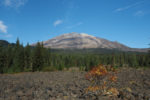
After about 2 miles you come out onto an old forest road and walk through a clearing with some views of nearby mountains. Goat Mountain is the largest humped mountain on your right and back behind you is Mt. St. Helens.
Cross over a forest road and continue up on the obvious trail at the other side of the road. You cross a tiny creek then continue upwards through a lush Forest. This part of the trail is carpeted with hemlock needles and climbs steeply up to cross a small forest road about 2 1/2 miles from the trailhead. Don’t take the Forest Road because it dead ends and it does not come back to the trail.
A little more than 3 miles along you round a corner and start climbing along the spine of the ridge. From here there are views of Mt. St. Helens and Goat Mountain and beyond through the trees. The climb gets a little more gentle here after the steep climb you’ve just finished so you can pause to admire the view and catch your breath.
Where the ridge flattens out you may notice a small trail break into the right. That is the actual cinnamon trail. If you stay along the ridge you will come out to a clearing with a minor view of Mt. St. Helens at the end of a forest road. Follow the forest road down about a 10th of a mile watching for where the trail crosses the road and get back on the trail.
Drop gently downhill and pass a nice view of Mt. St. Helens then go back into the woods. You’ll pass a small car camping site then back in the woods again then out to a clearing to the southwest where you can see Mt. Hood on a clear day.
Wind through the woods gently climbing and descending for about the next half mile then begin your dissent on switch backs down to the turtle trail. When you reach the Toutle trail turn right, go across the road, and continue up into the lava field. Walk as far as you would like then turn around and return via the Toutle trail.
If you didn’t bring enough water and have your filter there are several streams cascading down from the ridgeline above this upper section of the Toutle Trail. This section of the trail overall descends back towards the trailhead though there are minor ups and downs.
Soon you can see the Kalama River flowing down below you. Pass by some more glimpses of Mt. St. Helens as you weave along the river.
When you reach the next gravel Forest Road which is Forest Road 8100-600 walk across the creek on the road and look for the unsigned trail continuing downstream.
The trail along this next section is almost level as it follows the gently flowing stream back towards the trailhead through the woods. On a sunny day ripples in the river sparkle and the little rapids make those lovely river sounds.
After about 13 miles you’ll reach a signed junction with the Kalama Ski Trail and the Toutle Trail. Turn left here and make a hairpin turn dropping down towards the Toutle River.
Follow the Toutle River for about another half mile to where it comes to a junction for the Kalama Horse Camp. Go back up the hill to the trailhead and parking lot and bathrooms.
Enjoy the photos!!
Gallery Pics
Switchback Steve
