Clackamas River Trail, OR
Notice: 12/28/2021 – This trail is closed due to forest fires.
Vicinity Location:
The trailhead is about 50 miles southeast of Portland, Oregon in the Mt. Hood National Forest.
Directions:
From Portland via Estacada:
From Portland take I-84 east to I-205 south. Drive about 7 miles on I-205 S and take exit 13 for OR-224 W toward Milwaukie. Loop around and turn right onto OR-224.
Drive 2.1 miles and turn left onto HWY-212 E/OR-224. Continue for 1.6 miles and make a slight right to stay on OR-224 E for 36.4 miles, passing through Carver and Estacada. On the east side of Estacada, at the junction with Highway 211 for Molalla and Woodburn, keep straight on Highway 224 for the Upper Clackamas River and North Fork Lake.
Look for the sign for Indian Henry Campground and turn right on Sandstone Road/FR 4620 just before you cross over the Clackamas River. Drive down the paved road about 0.6 mile to the campground.
For the other end of the ride backtrack on Highway 211 for 6.5 miles and turn left onto Fish Creek Road and drive 0.2 mile and turn right into a large parking area.
No permits needed at Indian Henry Campground. Fish Creek has a $5 fee between May and October. This site is managed by Mount Hood Recreation (concessionaire for recreation sites). This site accepts Northwest Forest Passes but you still have to fill out the permit envelope. Pay with cash or check at trail head. However, Senior & Access Passes are no longer acceptable.
There are bathrooms seasonally at Indian Henry campground and seasonally at the Fish Creek campground. These campgrounds are adjacent to the trailhead.
Length and Elevation:
15.6 miles roundtrip. Elevation at the trailhead is 905 ft. Highest Point on the trail is 1,390 ft. There is 3,210 ft elevation gain and 2,850 feet elevation loss one way.
Trails:
Clackamas River Trail #715
There is at least one geocache for this trail at: N 45° 08.892 W 122° 06.253 Info at Geocaching.com.
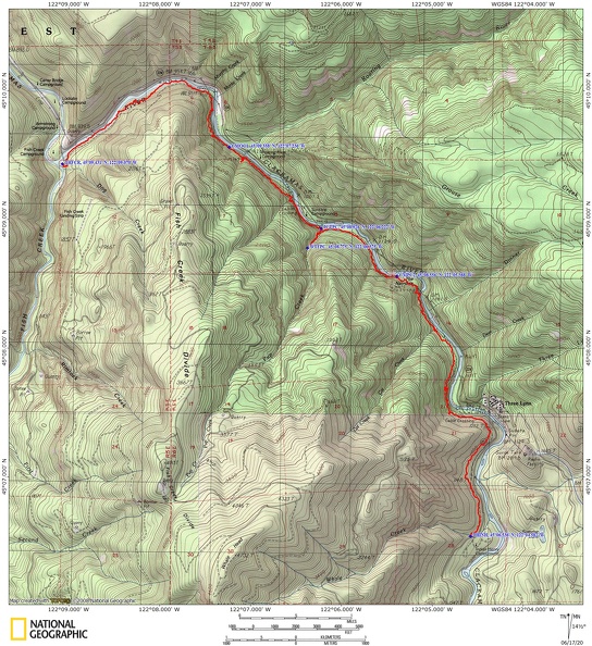
Trail Maps:
Topo Map, Download Garmin .gpx file, Open Garmin .gpx file
Review: May 28th, 2020
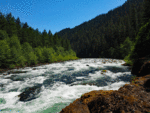
This trail enters the Clackamas Wilderness area which is mostly forested with great views of the Clackamas River. There are beaches, old growth forest, and Pup Creek Falls. There are several forested benches that provide areas for camping, picnicking and fishing.
The first part of the trail for the first mile or so goes up and down pretty much constantly. The trail is pretty rocky, and in some places, like walking on a loose cobblestone path. There is a wide variety of plants along the trail and there’s a mosaic burn pattern here and there from past forest fires. Most of the time you can’t see the road across the river but there are times when the road is just across the river. This area must be fairly damp because there’s numerous large cedar trees growing along the trail along with Douglas fir.
After about 2.5 miles you come down to a lovely cedar flat area with huge old growth cedars mixed with old growth Douglas fir. The trail here is a delightful winding walk through a primeval looking forest. The river is not far off and you catch glimpses of it through the forest., In spring you can’t but help notice the numerous skunk cabbages growing along this part of the trail. Their smell quickly alerts you to their presence.
The next section of the trail seems like you’re walking along the spine of a huge dragon that sleeps along the river as you climb over its rocky back.
Eventually you get to the junction to Pup Creek Falls. It is a short 0.2 mile, gently climbing, walk to a beautiful 2-tier waterfall plunging down a basalt cliff then hitting an apron of basalt below, spraying out as it cascades down into a green valley. In spring there are several places where the Clackamas Iris are blooming. It is a medium height with white and yellow flower.
This is one of the waterfalls that has a totally unobstructed view as you get close so you can really enjoy the sight of the 240-foot-tall waterfall.
After Pup Creek Falls the trail crosses the stream on lovely large flat stepping stones and climbs up to a loamy forest with lush undergrowth. If the trail hasn’t been brushed the bushes will hit you in the face. Be very careful because there is a place where there is head-high poison oak just as you see the first power tower.
This turns into a muddy section with giant horse tails and cow parsnips, passing a nice campsite, then ventures back into the loamy forest along the river. The trail soon leaves the forest floor and again scales up the river bank. There are some nice views of the river, another nice campsite, then up the rocky trail away from the river and through the dense forest.
After about 6 miles there is a little side trail that leads to the riverbank at a place called The Narrows where the Clackamas River is at its narrowest. This miniature gorge squeezes the river down to between 20 to 40 feet wide as it rushes through the chasm.
This area also has an area of old growth cedars and as you continue upstream you pass into the Clackamas Wilderness which was created in 2009. Climb away from the river through many large fir trees and the forest floor is lined with apple clover, maidenhair ferns and sword ferns.
At about mile 7 is a place where the layers of rock are of different strengths and the middle layer of rock has eroded away and left a gash along the cliff where the trail passes underneath the tiniest of waterfalls. Pass through this feature named Half Cave.
You’ll soon see Highway 224 below you on same side of the river as the trail. Pass beneath an overhanging rock cliff then drop into another pocket of cedar, hemlock, and Douglas-fir. The trail then climbs to a nice footbridge and passes through a patch of old blowdown. From here the trail climbs yet another a steep slope only to drop back down again.
Continue through the forest to the trailhead at Indian Henry Campground. Just before the creek there is a small user trail that leads upstream for a bit where you can enjoy sitting by Whale Creek. From here, catch to your shuttle or return via the trail to your start.
This hike is good for children who are experienced hikers. The trail traverses steep hillsides and some cliffs and children need to be experienced enough to stay back from the cliffs on the river. They should also know what poison oak looks like because it grows in many places along the trail.
Enjoy the photos!!
Gallery Pics
Switchback Steve