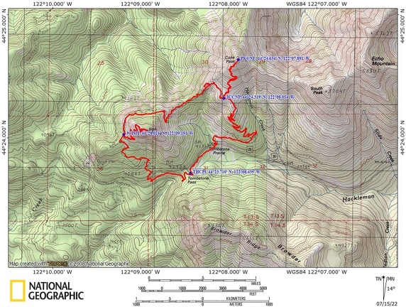
Cone Peak – Iron Mountain, OR
Directions: From Portland drive south on Interstate 5 to Albany, then take Highway 20 east through Lebanon and Sweet Home.
Continue on Highway 20 for about 35 miles. The Tombstone Pass is on the right.
A Northwest Forest permit is required to park here in summer and a Sno-park permit is required November 1 through April 30.
There is a restroom at the trailhead.
This is the Tombstone Pass / Cone Peak Trailhead. This parking area can fill to capacity early in the day. During prime flower season even on the weekdays the parking lot can fill up by 9:30 AM.
Length and Elevation:
Total distance is 8.2 miles. Elevation at the trailhead is 4,245 feet. Ascent 2,416 ft, descent 2,416 ft, maximum elevation 5,614 ft, minimum elevation 4,105 ft.
Trails:
Cone Peak Trail #3408, Iron Mountain Trail #3389, and Santiam Wagon Trail #3413.
Trail Maps:
Topo Map,
Download Garmin .gpx file,
Open Garmin .gpx file
Review: July 14, 2022
This first part of the trail has generally north east through a lovely old growth forest Parallel Lane highway 20. There is even a bench along the way where you can sit and contemplate a large patch of devil’s club across the path.
In just under 4/10 of a mile you walk along what is left of Tombstone Prairie. It was named for the tombstone from James McKnight who accidentally shot himself with his rifle and died on the spot..
Just after the meadow is a lovely little mountain stream. There’s also a junction for the Cone Peak Trail where you turn left and cross over a small creek on a sturdy little bridge.
It is just a short climb uphill to the highway. Look uphill (to the left) on the other side of the highway about 100 feet and you should see the continuation of the trail.
Climb up gentle switchbacks and come out to a rocky hillside about 1 1/2 miles from the trailhead. This climb is one of the loveliest forested climbs you will journey upon. The forest is a lovely all second growth of Douglas fir. The forest is open enough and so Cedars the forest is open enough to allow a pleasant blanket of underbrush but not so much but it totally hides the trail.
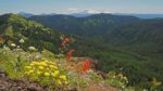
At 2 miles you burst out of the forest into a giant rocky meadow with a clear view of Cone Peak and the mountains around it. When the wildflowers are at their peak the vistas are incredible.
If you decide to climb up to cone peak follow the GPS track for this hike closely and bring trekking poles or gloves. This is about the safest route up to the top and it involves a little scrambling.
Once you come back down the trail re-enters the woods and you wind along in and out a little gullies with seasonal streams interspersed with rocky mountain meadows. You are now heading gently downhill off the shoulder of Cone Peak.
In about a quarter mile there is a little way trail leading off to the right uphill that ends at a basalt plateau giving an overview of Iron Mountain and Cone Peak and some of the surrounding forests. It is a nice sunny spot to enjoy the views for a bit. There are lots of stonecrop here in this dry barren rocky soil.
But don’t think it’s all downhill back to the parking lot. Soon you start a gentle climb through forests and more rocky mountain meadows. Trees are lovely second growth and when this review was done most of their deadfalls have been cleared off the trail. Going through the forest you pass a section of trees whose trunks were bent by winter snow creeping downhill. The bend stayed in the trees and now they look like they grew sideways for a while and then straight.
Eventually reach the junction for the Iron Mountain Lookout. Take the junction on the left and take the long fairly steep 7/10 of a mile climb along several switchbacks to the top. There’s some lovely open areas along the way and some forested areas with places to get into the shade.
At the top a large viewing platform has been constructed on the site of the former lookout. There’s some benches to sit on and a locator map but no shade.
Come back down the switchbacks and turn left back onto the mail trail and in about a quarter of a mile you come to a Junction for the Iron Mountain cut off trail leading to the right. Stay straight and the trail curves left and continues downhill. At the trail Junction there is a nice stone bench you can sit on if you need to rest in the shade.
Continue down the moderately steep trail through some forest meadows for about 0.8 miles down to the road.
Once you reach the highway the trail on the other side of the road is off to the right about 50 feet. It is unmarked so many people go straight across and down the steep embankment. Don’t go that way. Just walk to the right a bit and you’ll see the trail going through the thimbleberries and ferns, then turning left and dropping down below the highway.
In a few hundred feet from the highway you’ll come down to another trail Junction. Turn left here and head towards Tombstone Pass. At first the trail is just a gentle walk through the woods along a carpet of dogwood or bunch berries, white anemones, and twin flowers. The trail climbs and then drops, preparing you for the final climb up to the parking lot. Go up moderately steeply with a final switchback to a hill above the parking lot. Finally, drop down on the trail to the kiosk where you began.
Enjoy the photos!!
Gallery Pics
Switchback Steve