Cottonwood Canyon – Hard Stone, OR
Vicinity Location:
The trailhead is about 107 miles east of Portland, Oregon.
Directions:
From Portland, take I-84 E to exit 97. Take OR-206 E and drive for about 30 miles to Cottonwood Canyon State Park. Turn right just before the John Day River and drive down to the parking lot.
There are no bathrooms at the trailhead. The nearest bathrooms are east on the other side of Hwy 206 near the visitor’s center.
There are no fees or permits needed to park here.
Mountain bikes are not allowed on this trail.
Length and Elevation:
5 miles roundtrip. Elevation at the trailhead is 620 feet. Lowest point is 615 feet. Highest point is 670 feet. Total ascent is 470 and total descent is 470 feet.
Trail:
Hard Stone Trail
There are no geocaches along this trail.
Trail Maps:
Topo Map, Download Garmin .gpx file, Open Garmin .gpx file
Review: October 25th, 2019
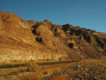
Walk on an old farm road which crosses the valley floor through sagebrush and a few willows. Rattlesnakes are quite common and there are ticks in the spring. Walk on the Hard Stone Trail passing under the steep sided bluffs keeping an eye out for big horn sheep.
The layers of basalt flows across the John Day River consist of Grande Ronde Basalts for the lower layers and Wanapum Basalts, which are about 15.5 million years old, above.The trail climbs a bit above the river at the Big Eddy because the steep hillside runs down to the river. Big Eddy is a deep whirlpool and rafters like to linger here at the end of their rafting trips. The island here is Hole Island and is home to nesting geese in spring. The sharp bend in the river at Big Eddy causes the trail to climb for a while but most of the time the trail is close to the valley floor.
In about 2.5 miles you come to Wellman Bend which is very popular with anglers. At the bend you can usually leave the trail and walk along a long gravel bar in the river. Return to the trail where you see a basalt bench dedicated to Norb Wellman. The far river bank has terraced basalt cliffs along Wellmand Bend, a wide bend in the John Day River. Continue to a big juniper tree that sits beneath a towering peak. The jeep road continues but it looks like this is the end of the deepest part of the canyon and the end of the official trail at this time.
From here enjoy the majestic basalt canyon then retrace your track, keeping an eye out for rattlesnakes and big horn sheep.
Enjoy the photos!!
Gallery Pics
Switchback Steve
