Coyote Wall, WA
Notice: 5/24/2019 – The full length of Raptor Trail in the Coyote Wall area are closed from February 1 to July 15 to protect nesting peregrine falcons, bald eagles, and other sensitive wildlife and natural resources.
Vicinity Location: About 63 miles east of Portland, OR.
Directions:
From Portland, OR, take I-84 East to Hood River. Cross over the Columbia River using the toll bridge and turn right on Hwy 14. Drive approximately 4.7 miles through Bingen and to the junction with Courtney Road on the left. Turn left and take an immediate right into the parking area.
A Northwest Forest Pass is required to park. There is difficulty finding parking on weekends.
There is a restroom at the trailhead. The nearest restroom with a flush toilet is at the Chamberlain Lake rest area, about 4.2 miles east on highway 14 at MP 73.
Length and Elevation:
6 mile loop. Elevation gain is 1,875 feet and loss is 1,875 feet. Elevation at the trailhead is 120 feet and is the high point is 1,890 feet.
Trails:
Coyote Wall Trail #4428 (Co1), Little Maui Trail #4425 (Co5), Little Moab Trail #4424 (Co3), Old Ranch Road Trail #4426 (Co4). Connections to multiple trails.
There is at least one geocache along this trail at: N 45° 42.307 W 121° 24.425. Info at Geocaching.com
Trail Maps:
Topo Map, USFS Map, Download Garmin .gpx file
Review: May 16, 2011, April 9, 2017, October 30, 2021
Coyote Wall is a large basalt formation towering to the east of the trailhead.
From the parking lot head east on the abandoned highway. Traveling this road shows the dramatic effects of the freeze-thaw cycles fracturing rock off the cliffs.
Turn uphill at the second main trail junction, just before a stream. Follow the fairly steep trail up through the rocks to nice views of the Gorge. The thin topsoil keeps the trees from growing thickly along much of this trail. It isn’t long before you pass a little cave on the left and then walk alongside a very pretty waterfall. Watch out for poison oak if you decide to venture to near the base of the falls.
Keep to the main trail as the views become more open and you can gaze far into the eastern parts of the Gorge. After a couple miles of climbing the trail reaches a junction where you turn left and head west. Follow this abandoned road as it drops down to cross a stream then climbs up through an oak forest to cross a large grassy slope. Early spring is a great time to see the slopes mantled in green grass speckled with wildflowers.
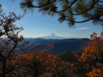
Near the wall, turn left and head uphill to a meadow at the edge of the forest. There are spectacular views of the Gorge and Mt. Hood in the giant meadow with only a few scattered trees. Enjoy the great views from here then head back downhill with constant views of the Gorge and Mt. Hood. Remember to move aside for mountain bikes.
Wander straight downhill or take the mountain bike path which has some nice views of Coyote Wall. As you continue downhill you’ll pass a couple of old barbed-wire fences. The next major junction has a side-trail to the left that drops down and crosses a stream. If you take this trail then you’ll need to turn right at the next junction and follow the trail downhill to the old State Highway 14. From there, follow the road west back to the trailhead.
Continuing straight ahead at this junction, keeping the stream on your left and continue towards the Columbia River. The trail has sweeping switchbacks that lead down to the abandoned old State Highway 14. From here continue to the right, which is west, back to the trailhead. Early in the season there are a couple of small streams cascading over the cliffs but they soon dry up as drier weather ensues.
This may not be the best choice for young children due to the cliffs, ticks, poison ivy, and hot weather that are frequently encountered in this area. Be sure to check for ticks during the hike and again back at the car. That being said, this hike is a “must” spring hike.
Enjoy the photos!
Gallery Pics
Switchback Steve