Dalles Riverfront Trail, OR
Note: The road is gated and the trail closed the seasonally from Riverfront Park east to the Dalles Dam. The seasonal closure runs from November 1 to Memorial Day Weekend.
Vicinity Location:
The trailhead is about 80 miles east of Portland, Oregon in the Columbia River Gorge National Scenic Area
Directions:
From Portland drive on I-84 E toward The Dalles for about 79 miles.
Take exit 82 and at the stop sign turn right onto River Road.
Drive about 400 feet and turn right onto Historic Highway 30W and drive for 1.4 miles and turn right on onto Taylor-Frantz Rd.
Drive about 0.5 miles on this road and it turns into Discovery Drive and leads to the parking area at the Columbia Gorge Discovery Center & Museum.
Bathrooms are inside the Discovery Center and you might need to pay admission to use the bathroom. There are restrooms at the marina 6 miles east of the trailhead.
No permits are required to park at the trailhead.
Length and Elevation:
Between November 1st and Memorial Day: Total length is 12.6 miles out and back. Elevation gain is 250 feet and 250 foot loss. Elevation at the trailhead is 210 feet, the high point is 210 feet. Lowest point is 120 feet.
Trail:
Dalles Riverfront Trail
There is at least one geocache along this trail at: N 45° 38.848 W 121° 12.380 Info at Geocaching.com
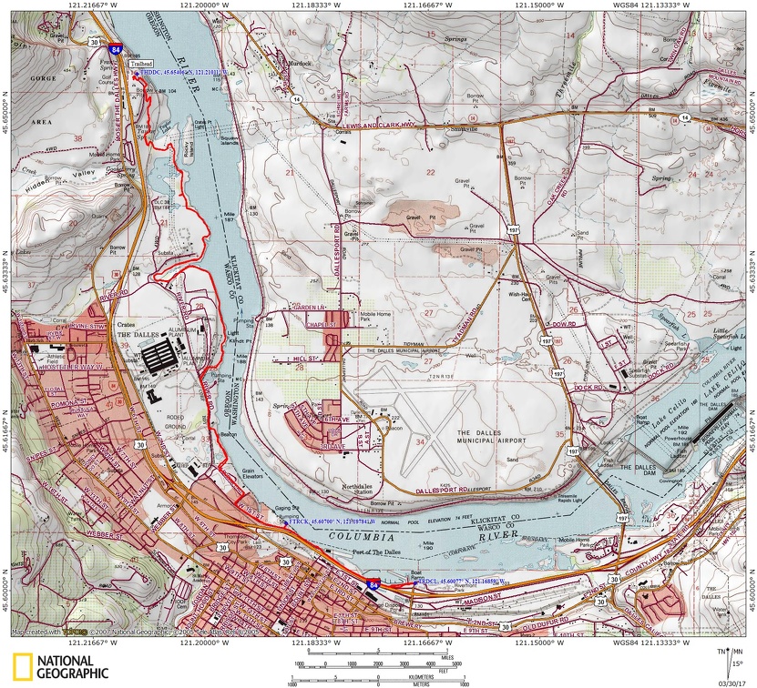
Trail Maps: Topo Map, Wind and rain forecast for The Dalles, Parks Map, Download Garmin .gpx file
Review: 3/26/2017
The Riverfront Trail is a paved trail that follows the south bank of the Columbia River at the historic “bend in the river,” where the Columbia bends about 90-degrees, changing from an east-west flow to a northward flow.
The Riverfront Trail is accessible approximately every mile of the western six miles between The Discovery Center and Riverfront Park. After the first six miles there are no access points to the Riverfront Trail because the trail parallels the I-84 freeway.
The Gorge experiences many windy days so you will want to use the link above to review the wind forecast before you go.
Plan to spend some time looking at the exhibits at the Discovery Center before hitting the trail.
Take the Riverfront Trail as the paved route descends sweeping switchbacks through an open forest of oaks to pass underneath the Union Pacific Railroad tracks. Pass over an open hill broken up with outcroppings of columnar basalt. Soon you’ll pass by wetlands and Taylor Lake on the right.
The first few miles of the trail is far enough from the freeway that the road noise is faint though you will hear the sounds of trains along the river and boats on the river.
Pass by an osprey pole positioned near the river. Then you come to an industrial area with several very large buildings including one for Google.
The trail passes a lot of interesting sites both modern and historical. It goes from being along the river to industrial area, to being on a fenced bluff along the river.
At 5 miles there is an area where Lewis and Clark camped and there are several informative plaques about their camp in 1805.
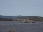
After 6 miles you reach Riverfront Park where the road is gated for the seasonal closure which runs from November 1 to Memorial Day Weekend. From the marina there are nice views of The Dalles Dam and the bridge across the river.
On the way back you pass Bent River restaurant where you can stop in for a snack.
Crossing back under the railroad tracks you make the final climb back up to the parking lot. This can be a workout if the wind is blowing from the west.
This is a great hike or bike ride for children as you can turn around at any time and there are no cliffs or really steep dropoffs. Kids will like the historical exhibits at the Discovery Center.
Enjoy the photos!!
Gallery Pics
Switchback Steve