Deschutes River Trail, OR
Vicinity Location:
About 86 miles east of Portland, OR in the Columbia River Gorge.
Directions:
From Portland take I-84 east to exit 97. At the stop sign turn right and then after about 50 feet turn left. Drive to 2.8 miles crossing the Deschutes River and make a right turn into the parking lot. Drive about 0.2 mile into the campground and you will find one of the day-use parking area.
There are bathrooms at the parking lot and at a couple points along the way.
No day use fee. Need a $7 per night parking permit.
There are two overnight parking areas. One parking lot is right at the trailhead by the park entrance and one inside the park near the ranger’s office.
Length and Elevation:
Total mileage 38.6 miles, total elevation gain of 1,300, total elevation loss of 1,300.
Trailhead elevation: 147 feet, highest elevation: 513 feet at the turnaround point, lowest elevation: 147 feet at the trailhead.
Trail:
Old Railbed Trail
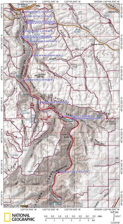
Trail Maps:
Topo Maps, Wind and rain forecast for The Deschutes River, Download Garmin .gpx file
Review: 4/22/2018
If you decide to hike this instead of biking, you can take a trail from near the ranger station up to the Deschutes River Trail. On your bike find the trailhead and the wide gravelled trail that starts from the entrance.
Starting up the trail you soon pass some old equipment and a junction on the right to a trail that leads down into the park. Continuing along you enter the burned area through a landscape that was once sage and wild cherry trees. Cherry trees bloom early in the spring and are followed by lupine, balsam root, and many other wildflowers.
Climb gently for a couple of miles, passing junctions for Ferry Spring Trail and other trails. Once your get away from the developed area of the park be alert for snakes. There is a good chance there will be snakes somewhere in the trail and they don’t always slither out of your way and some are rattlesnakes.
The next couple miles of the trail are fairly level. Enjoy the expansive river views and the different textures of the basalt rock that line the trail and hem in the valley. Pass by Rattlesnake Rapids and other whitewater sections of the Deschutes. The railroad track on the far side comes from Bend and follows the river.
About 5 miles from the trailhead was an abandoned boxcar sitting by the side of the trail. A fire on the Deschutes burned all of this and only the iron pins and plates are left.
If you are planning to turn around at the ranch there is a nice camping area about ½ mile before you get to the ranch. It is a dirt road that heads towards the river. There is an outhouse, river access, and plenty of flat areas to camp. This will be hot camping in the summer as most of the trees have burned.
There are some plowed fields near Harris Ranch. This agricultural land is planted with spring barley to provide supplemental feed and winter cover for various wildlife species.
All the buildings at the Harris Ranch have burned in the Deschute River fire of 2018.
About 500 feet past Harris Ranch was an old water tower that served the Deschutes Railroad. There water tower was restored in 2009, the 100th anniversary of the water tower, and a plaque commemorating the effort for the was built nearby. The metal hoops and plaque are all that remain.
Cross another small stream and continue along the trail as it passes cliffs made from blasting for the railroad. The trail starts climbing a bit more above the river and is almost entirely out of brush and trees affording sublime views up and down the gently winding river.
After Harris Ranch there isn’t any water crossing the trail but the river is alway there in the bottom of the canyon. There is an old overgrown service road that makes a relatively easy descent down to the river floodplain and the river. This is the area we chose to camp.
Continuing up the river the trail finally hits a large gully that used to have a trestle. From here the trail gets very rough which makes this a great place to turn around and head back to the campsite a few miles back.
We met some people who had camped out the previous night but I don’t think they chose the same campsite that we did. We found a spot with shade and the river nearby. This site can be very windy so fires are not advisable during windy conditions. We didn’t make a fire anyway.
About 75% of the trees along the river have been burned. River access was easy but it didn’t really look like a good place for swimming. We fell asleep to the sounds of the river and several trains passed on the other bank during the night.
The next day was an easy ride because the grade is downhill overall. We rode out to the beginning of the park to use the end of the gente railroad grade all the way down to the park entrance.
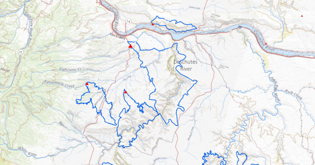
Here is a map of the 2018 fires that burned on the Deschutes. The blue areas outline the fires.
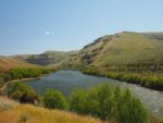
Enjoy the photos!!
Gallery Pics
Switchback Steve