Devil’s Garden Trail, Utah
Vicinity Location: 814 miles southeast of Portland Oregon near Moab, UT in Arches National Park
There are bathrooms in the parking lot.
No pets allowed on this trail, and most National Park Trail
National Park Entrance fee of $30.00 for a car 7 day pass or $25 for a motorcycle 7 day pass and a single passenger or Annual Pass is required to enter the park.
The area parking can be full any day of the week but always fills on weekends when the weather is decent.
There is water at the trailhead.
Length and Elevation:
9 miles round trip. Elevation gain 1,700 feet and 1,700 feet loss. Total gain and loss is 3,400 feet. Elevation at the trailhead is 5,175 feet. The high elevation of the trail is 5,499 feet and the lowest elevation of the trail is 5,020 feet.
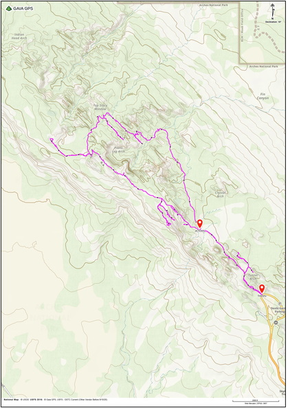
Trail Maps:
Topo Map, Download Garmin .gpx file, Open Garmin .gpx file
Trail:
Devil’s Garden Trail.
Review: April 14, 2026
The trail starts by the bathrooms and goes through a narrow chasm between red sandstone cliffs. Soon it opens up into a desert meadow and you come to the first junction where you turn right. At the next junction turn right again and you soon reach a view for Tunnel Arch.
After viewing the arch, head back to the main trail then go straight, walking along a wide gravelly trail towards Pine Tree Arch.
This part of the park looks like it receives a little more rainfall than other areas with many juniper, Mormon, tea, Yucca, prickly pear, and a fair amount of spring wildflowers.
Follow the gentle rises and falls a short distance to Pine Tree Arch. You can go a bit past the arch walking on the sand and have some nice views across the valley. Turn around and head back towards the main trail turning right at the next two trail junctions to bring you back onto the main trail.
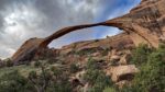
After walking about 1.5 miles you come to Landscape Arch. It is a thin, delicate sandstone arch arching above you. The fenced trail leads to very nice view of the arch so don’t think about going off-trail.
Head back down to the main trail, make a right and start on the primitive trail towards more of the arches. This trail goes up and down slick rock and is not recommended when conditions are very wet out or icy.
Climbing up through the rocks, you soon come to a flat spot with a narrow rock spine heading back to the way you came. You can follow this back out to the end for some nice views of the trail you just climbed up.
In a little more than 2 miles you reach a trail junction for a side trail to Partition Arch, and with another trail splitting off to Navajo Arch.
Taking the left at the next junction leads you on a short trail to Partition Arch, which affords a nice view of the parking lot and valley below.
After viewing the arches and returning to the main trail, the next section is pretty wide and flat and easy to navigate. You’re on top of a mesa and have views of sandstone and distant spires.
Continuing along, you’ll come to a short trail to the right that goes to an overlook of the black arch. If you look down, you’ll also see what may be the park’s tiniest arch at your feet
The trail descends a narrow ridge then turns and comes out at the OO or Double O Arch.
Nearby is a side trail that leads to the Dark Angel spire. Follow the side trail as it drops down into gullies and washes and climbs up sandstone ramps to Dark Angel spire which is a somewhat phallic looking rock sticking out above the landscape.
Return back and then head down the trail being, thankful for the trail signposts bolted into the rock.. After a while, you come to the junction for Private Arch, where you go up a barely noticeable trail.
The trail eventually comes to a spot where the sign points to a very steep slope that you need to scoot down. Just before the very steep sloping trail, on the right, is a spine that you can walk out on for a terrific view of the needles.
Come back to the steep section, scoot down the sandstone for about 8 feet, then make your way across more steeply sloping slick rocks.
After hiking about 6.75 miles you come into a wide wash. Follow this for a bit and then pay attention for the sign where the trail leaves the wash. Climb up what feels like a big sand dune and then gently descend back to your outbound trail to complete the loop by following the trail back to the parking lot.
This trail is fun and frightening. Do not take people afraid of heights, or people not confident walking on steeply sloping sandstone, very uneven trail, and some squeezing between rocks. Do not take small children, I would even say the youngest hikers to go on this hike would be experienced 12 year olds. Do not carry babies in backpacks.
Be sure to have this route in GPS software that you can follow. Carry 3 liters of water per person when temperatures are in the 80’s. If you are confident in being able to hike this trail this is a “must do” hike.
Enjoy the photos!!
Gallery Pics
Switchback Steve