Eagle Creek, OR
Vicinity Location:
37 miles east of Portland, Oregon in the Columbia River National Scenic Area.
Directions:
From Portland, Oregon, take I-84 east for about 40 miles and take exit #41 for the Eagle Creek Recreation Area. The exit is just after the highway tunnel. Follow the road to the right, up a one lane paved road to the trailhead. Parking is limited and this is one of the most popular trails in the Gorge.
From Hood River, Oregon, take I-84 west to exit 41 and return to the freeway eastbound. The exit is just after the tunnel. There is no westbound exit at Eagle Creek.
Vandalism is a big problem at this trailhead. Don’t leave anything valuable in your car and don’t park here overnight. Overnight parking is available at the main parking lot, near the campground host.
The bathrooms in a stone building near the trailhead and water are available at the trailhead in the summer months. Only portable toilets at the trailhead are available during the winter.
A Northwest Forest Park permit is required to park at the trailhead.
Length and Elevation:
Trailhead elevation: 180 feet. 1500 feet gain, 100 feet loss for the first 7 miles. 2250 feet gain for the next 5 miles to Wahtum Lake.
Trail:
Eagle Creek Trail #440 with connections to #400, #406, #416, #433, #434, #435, and the Pacific Crest Trail.
There is at least one geocache along this trail at: N 45° 36.505 W 121° 52.927. Info at Geocaching.com
Trail Maps:
Topo Map, National Forest Service Map, Download Garmin .gpx file
Review: June 7, 2007, December 17, 2016
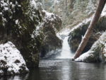
This is one of the most popular trail in the Columbia Gorge. Expect parking to be an issue during weekends in the summer. The well-used trail gently climbs above the creek and passes along basalt cliffs. Cable railings have been installed where the trail passes the cliffs. The trail has been blasted into the cliffs at a couple of sections. About 2 miles up the trail is the junction to Punchbowl Falls. This nice 25 foot tall fall spills into a grotto with a large pool good for summer swimming. Rejoin the trail and continue about another mile to Metlako Falls. Here was a nice overlook of the falls but recent landslides have closed this viewpoint. About another mile is Loowit falls. The trail continues up the canyon on the east side of the stream. Steel bridges pass over some of the side streams and there is one step-across crossing. The trail continues to High Bridge, where the creek is 150 feet below the bridge. Look for a geocache in this area if you have got the necessary information from the link at the beginning of this review. The trail follows the west side of the canyon then crosses Eagle Creek on another bridge in about ½ mile. After Wy East camp is a junction to the left for trail 434. Pass this junction and continue along the stream on trail 440. At about 6 miles up the trail is Tunnel Falls where the trail is blasted into the cliff and passes behind the falls. The trail is narrow along the cliff but thanks to all the foot traffic the rocks are just wet and not slimy from moss growing. The trail leaves the cliffs for a bit, then in a short time passes another cliff where the trail rounds a corner and passes just past the top of another waterfall. What a great place to pause for a bit and be mesmerized by watching the water fall over the edge and plunge to the streambed below. The next 200 feet of trail are part of the streambed so you need to walk carefully. The trail begins to get away from the creek after this and it becomes narrower from the lower level of use, especially after 7 ½ Mile Camp. You’ll pass camping areas along the way but they fill quickly. Turn left at the junction of the Eagle-Tanner trail 433. The Eagle Creek Trail climbs away from the creek and ends at Wahtum Lake.
The cliffs on this trail make it inappropriate for inexperienced hikers. People have fallen off this trail with serious injuries and two people have died in a three week period in early 2009. Turn back if the trail is icy or snowy near the trailhead. With that warning, this is the arguable the most beautiful trail along a stream without a lot of elevation gain in the Gorge.
Enjoy the photos!!
Gallery Pics
Switchback Steve