Falls Creek Falls Winter Route, WA

Vicinity Location:
The trailhead is about 37 miles northeast of Portland, Oregon in the Gifford Pinchot National Forest.
Directions:
From Portland take I-84 to Cascade Locks. Take exit 44 and then the first right turn, just after you go under the Bridge of the Gods. Pay the $3.00 toll, cross the bridge, and turn right onto Highway 14 and drive 2.5 miles to Stevenson.
Once you get to Stevenson, drive about 2 more miles east to the traffic circle and take the 2nd exit for Wind River Road. Wind River Road is 5.9 miles east of the Bridge of the Gods.
From the traffic circle drive 18.5 miles on the Wind River Hwy which turns into FR30 to a pulloff on the right side of the road. The pulloff is also 17.5 miles from the 4-way stop sign in Carson, WA.
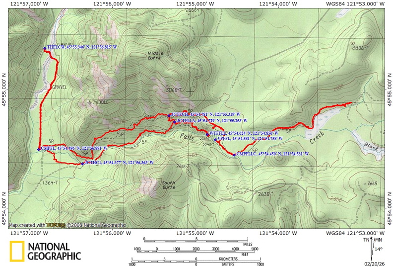
Here are the trailhead coordinates that can be pasted into maps or opened in Google Maps: 45.92247, -121.9469
No permits needed to park.
No restrooms at the trailhead.
Length and Elevation:
Total trip is 14.2 miles. Elevation at the trailhead is 1,380 feet. Total ascent is 2,640 feet and total descent is 2,640 feet. Highest point is at 2,415 feet. Lowest point is 1,309 feet.
Trail Maps:
Topo Map, Download Garmin .gpx file, Open Garmin .gpx file
Trails: Falls Creek Falls Trail #152, Falls Creek Falls Trail #152A, user trails.
Review: February 20, 2026
Look for a pullout along the road, and there is a very large log across the creek to cross on. It even has some shingles nailed to it for extra traction.
At 1.4 miles you’ll pass a junction on the right. That is the return trip.
So far the trail has been almost perfectly flat. From here you start gently climbing within the sound of Falls Creek. The forest is a second growth of mostly Hemlock with some cedars and grand firs and Douglas firs mixed in. There is a brushy under growth mainly of slough and some Oregon grape along this first portion of the Trail.
At about 1.9 miles the trail starts to get steeper and you pass a little viewpoint off on the right. From here, the trail narrows and starts climbing through a forest with some older trees in it. Some of these trees are a good 2 to 3 feet across.
The trail continues a moderately steep climb back into younger second grow growth trees. It also gets further away from Falls Creek, though you can still hear it in the distance.
After about 3 miles pass a signed junction on the right which goes downhill to the Falls Creek Falls Trail. This is for the return trip.
From here, the trail is quite steep as it rapidly ascends through a lovely second growth forest. This section of the trail is in really good shape with a wide bench and not much brush.
After 3.5 miles the climb ends and you transition to a nice flat area. There’s a nice mix of cedars and hemlock in the forest here. At this elevation, some of the trees aren’t terribly big, but they grow really slow so it is definitely an old growth forest through here. If you look around, you may see some old blazes put on the trees.
At about 3.75 miles is a user trail off to the right. This leads to rock cliffs that overlook part of Falls Creek Falls and has a nice view down the valley. After about 4 miles you reach an area where you can stop and have lunch or a snack with a great view of the stream below. From here you can turn around or if you would like as we did in this review you can venture further up the fairly level, well maintained trail through the forest.
At about 4.3 miles you come to a wonderful spot with a small cascading waterfall and a couple of great campsites. This could be a nice weekend destination. You can hike about 1.5 miles farther passing a marsh and a large talus field. Turn around where the map shows a road, though the road has been abandoned for sometime and is getting brushy.
Heading back again and admire the old growth trees as the trail meanders through the forest. At the next trail junction turn left and drop down steeply for about 0.1 mile to the Falls Creek Falls Trail and turn left to follow the Fall Creek Falls Trail to the waterfalls.
The trail to the falls climbs fairly steeply for a while and crosses two streams. One is crossed on a nice bridge and the other is a step across. After that, the trail levels out and becomes much rougher before heading downhill to the viewpoint for the waterfall.
This view is spectacular seeing and listening to the raging creek plunge over cliffs to a misty pool below you. Return the way you came continuing downhill at the next junction to follow Falls Creek.
The trail here is kind of rough and at about little over 10 miles you passed go by more old growth trees with some of them 5 feet across.
Cross over a suspension bridge and follow along the creek until you get to about 11 miles to a junction where you turn right to go towards the horse camp.
At about 11.5 miles you’ll reach a junction for Trail 152 where you turn right to cross the creek over a nice log bridge. Walk about another 0.1 mile and then turn left where you meet the you started on. This leads back along the old railroad grade to the log crossing and the pullout where you parked.
Enjoy the photos!!
Gallery Pics
Switchback Steve