Greenleaf Falls, WA
Notice: 11/25/2017 – Bonneville Hot Springs has been sold and the new owners aren’t allowing parking at this time. The bridge over the outlet of Carpenter’s Lake is out.
Vicinity Location:
About 36 miles east of Portland, OR in the Gifford Pinchot National Forest.
Directions:
From Portland, take I-205 North to Exit 27 towards Camas. Merge onto Hwy 14 East and drive about 31.5 miles.
Turn left off Highway 14, drive a few hundred feet, cross under the railroad tracks, then turn right at the T in the road onto Cascade Dr.
Drive about .75 mile, crossing over a couple of creeks, then turn right on Hot Springs Ave (some maps may call this E Cascade Dr.), drive about .1 mile and turn left. Drive a few hundred feet further and park in the lot which is west of Drive to Bonneville Hot Springs Resort.
This is a private parking lot for resort customers and a permit is required to park at the trailhead.
There is a restroom at the trailhead.
Trails:
Dick Thomas Trail, Two Chiefs Trail, Unnamed trails.
There is a geocache at: N 45° 39.608 W 121° 58.556 Info at Geocaching.com
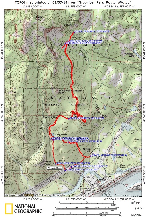
Trail Maps:
Topo Map, Download Garmin.gpx file
Length and Elevation:
Distance is 9.2 miles. Trailhead elevation is 75 ft. There is 1,400 feet elevation gain and 145 feet of elevation loss to Greenleaf Falls. The return trip with the viewpoint near Greenleaf Falls has 250 feet of elevation gain and 1,500 feet of elevation loss.
Review: January 5, 2014.
There are six different ways to access the trail to Greenleaf Falls. This review provides directions for the two of the routes that converge at Carpenters Lake.
This set of directions is shorter, steeper, and passes through a couple of blackberry patches.
From the west end of the parking lot, head up the gravel road, fairly steeply uphill for about 300 feet. Where the road T’s off, turn left and walk about 30 feet and turn right on a small footpath. Navigate through a couple of blackberry patches then head steeply up the hillside. It would be a good idea to bring some hand clippers to help get through the blackberry bramble.
After climbing steeply for about .25 mile, the ascent becomes more gradual, then levels off as you approach the same elevation as Carpenters Lake. The trail crosses the outlet of Carpenters Lake on a homemade footbridge, then soon comes to a junction with an ATV trail. This is where the directions from the two starting points converge.
This alternate set of directions to Greenleaf Falls is longer, less steep, and passes under huge power towers. From the west end of the parking lot, head up the gravel road, fairly steeply uphill. Where the road tees off, turn left and walk along a jeep trail. The track runs over hill and dale for about .2 mile, crossing a wet depression then climbing to a 4-way junction at some large power towers.
From where you first cross under the big powerlines, walk about 100 yards, going down a dip, over a small culverted stream, which is Carpenter Creek, then back up again. At the top of the next rise, turn right on an old, unmarked jeep trail which heads uphill. Walk about 100 yards, crossing underneath the powerlines again and at the end of the jeep trail is a footpath leading into the forest.
For the next .4 mile, the trail climbs for a short distance, then drops into a small gully and crosses a small stream. There is a level section of trail for, then it drops into a small gully and stream then up to an ATV road.
Turn right at the ATV road and walk up the muddy and rocky trail about .4 mile to a junction with a small trail going off to the right. This junction is just before a large grassy meadow, which was once Carpenters Lake. This is where the directions from the two starting points converge.
It was beavers that made Carpenters Lake. They built a dam at the outlet and flooded the area. Now the beavers are gone and there is only a small pond at the east end of the bog.
Now go from the 3-way junction at Carpenter’s Lake, bearing to the right on the ATV road. In a short distance there is another 3-way junction. Bear right again, leaving the ATV trail. The ATV road that goes to the left leads to Aldrich Butte.
The trail winds along the west side of Carpenters Lake and passes through a forest of fir and alder. After about .5 mile, it crosses a small creek on a bridge and continues uphill through the forest. Continuing along the present track you’ll come to a 4-way junction with the PCT about .8 mile from Carpenters Lake. The PCT at the time of this review has a trail marker on a tree in each direction.
After the junction with the PCT, the trail climbs gently for over .5 mile, with occasional glimpses of the gorge. Hook around the edge of a small ridge then drop down into the forest of fir trees. Continue to gently gain elevation as it passes below Sacaquawea and Papoose Rocks. The cliff face of Table Mountain looms ahead, high above the trail. This trail is mostly through a forest of fir and alder with a few rocky spots where it cuts through talus slopes of basalt which slid off of Table Mountain about 700 years ago.
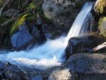
Greenleaf Falls is a nice waterfall that cascades down just above the trail. The falls aren’t very tall but the creek certainly rushes down the mountainside. Crossing this stream is much easier if you have trekking poles to provide extra balance as you step from rock to slippery rock.
This is a good place to turn around, but the trail does continue another couple of miles to Blue Lake Road. You could set up a shuttle hike for this trip.
Coming back, there is an old logging road about .5 mile from the falls. You can follow the track uphill about .25 mile to some nice overlooks of the Gorge. The abandoned road ends at a large rockslide. People have camped here and the campsite has some nice views of the Gorge.
The trail is mostly downhill except for one short moderately steep uphill stretch where the trail climbs a small ridge then hooks around to the right.
Follow the trail back to Carpenters Lake and if you have the inclination, walk about .6 mile and gain 500 feet in elevation to the top of Aldrich Butte.
From Carpenters Lake, choose the return route back to the trailhead.
This is a most enjoyable trail. It is safe for dogs and kids and has a modest elevation gain. The only tricky part is if you want to cross Greenleaf Creek. The creek has large, slippery rocks to cross on. If you don’t mind wading then this is not a problem but the creek is fairly swift and can be almost knee deep in some spots.
Enjoy the photos!
Gallery Pics
Switchback Steve