Historic Columbia River Highway State Trail Wyeth – Viento, OR
Vicinity Location:
About 35 miles east of Portland, OR in the Columbia River Gorge National Scenic Area.
Directions:
From Portland, Oregon, take I-84 east to the Wyeth exit, turn right at the bottom of the off ramp, in about 50 feet turn right again onto Herman Creek Road. This is also the Historic Oregon US 30 route. Follow the road about 0.2 mile and make a left into the Wyeth Trailhead parking lot.
There is a bathroom at this trailhead and no permits are needed to park.
Length and Elevation:
Distance is 11.9 miles roundtrip. Elevation at the trailhead is 147 feet. Highest elevation is 200 feet. Elevation gain is 200 feet and elevation loss is 200 feet.
Trail:
Historic Columbia River Highway State Trail – Wyeth to Viento – Mitchell Point Segment
Trail Maps:
Topo Map, Wind and rain forecast for Hood River, Download Garmin .gpx file, Open Garmin .gpx file
Review: 10/1/2019
Just at the beginning of the trail is a water spigot right next to the trail. Water is available spring, summer, and part of fall.
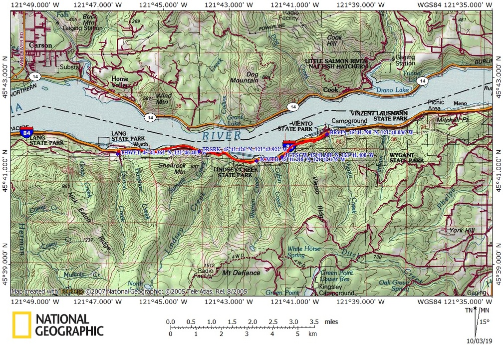
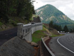
Travel through the forest and along the freeway for about 1.5 miles where you come to the Summit Creek Viaduct which climbs up above the busy freeway. This viaduct skirts Shellrock Mountain and this part of the trail was an expensive and challenging part of this section of trail. There are a couple of balcony viewpoints on the viaduct where you can get off the trail and admire the view. Huge cable rock fences guard against boulders crashing onto the trail and riders.
At about 2 miles is the junction for the Mt. Defiance Trail. Head over here for a nice view of Hole In The Wall Falls. A tunnel was blasted through the basalt cliff to make Warren Falls dry up. This was done so that in times of heavy rain, Warren Falls wouldn’t flood the old Scenic Highway. Today the only time you can see water cascading down Warren Falls is during heavy rains, and even then Warren Falls is only a tiny cascade.
About 100 feet past the Mt. Defiance Trail junction is a giant anthill on the left. This anthill has been here for a very long time, I’ve known about it for at least 20 years. I can only imagine how many little kids, and probably adults too, have poked sticks into the anthill over the years.
Go about another 0.2 mile and you come to Cabin Creek Falls which is a delightful little waterfall coming out between two basalt pillars and cascading down into the forest and flowing north to meet the Columbia River.,
On this section of trail you’ll see a lot of licorice fern carpeting the rocky slopes next to the trail. Just a little farther at mile 4 is Starvation Creek Wayside where there is water and bathrooms. About 200 feet further up the trail is a paved trail on the right leading to Starvation Creek Falls. This 220 foot tall waterfall plunges from the basalt cliffs in two tiers down to the streambed which flows right next to a couple of picnic tables and makes for a great spot to stop for lunch.
Continue slightly downhill to Viento State Park. There are some bathrooms about 50 feet on the right side of the road. The campground is the turn-around point and the end of the trail until the next section is built.
Enjoy the photos!!
Gallery Pics
Switchback Steve