Indian Heaven, WA
Vicinity Location:
About 56 miles northeast of Portland, OR. in the Indian Heaven Wilderness west of Mt. Adams and north of the Columbia River.
Directions: There are other ways to get to the trailhead but I like this route because it is paved almost all of the way. From Portland, take I-84 E and drive for about 60 miles.
Take exit 64 for Mt Hood Hwy toward White Salmon. Proceed .2 mile, turn left, cross under the freeway, and take the Hood River Toll Bridge, driving about 1 mile across the Columbia River into Washington.
Turn left onto WA-14 W and drive 1.5 miles.
Turn right onto WA-141 Alt N and drive about 19 miles to Trout Lake.
At Trout Lake make a slight left to stay on WA-141 N, following signs for Sno-Parks, for 8 miles, noting that Highway 141 becomes Forest Road 24 at the forest boundary.
Turn right at the junction with Forest Road 60 to stay on NF-24. Drive for about 9 more miles past Little Goose Campground to Cultus Creek Campground. Turn left into Cultus Creek Campground and look for the trailhead. The official trailhead has room for about 5 cars but other spots can be found, however don’t park in the spots for the campsites.
A Northwest Forest Pass required. A free wilderness permit, available near the trailhead, is required to be filled out during the busy season.
You must camp at established sites at Blue Lake and Tombstone Lake and in the Thomas Lake area.
There is an outhouse near the trailhead.
Trail:
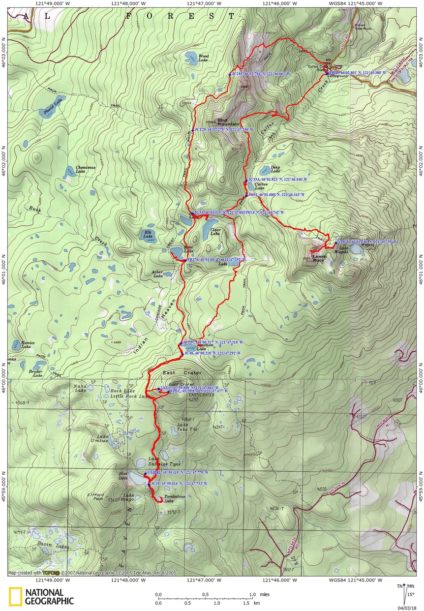
Indian Heaven #33, Lemei #34, Wapiki Lake #34A, Lemei Lake #179, Pacific Crest Trail #2000, Tombstone Lake #55, Thomas Lake #171, Elk Lake #176, Cultus Creek #108, Shortcut Trail #171A, Cultus Creek #108 with connections to Placid Lake #29 and East Crater #48, and Wood Lake # 185
There are no geocaches on this route.
Trail Maps:
Topo Map, Designated Camping Maps (PDF), Download Garmin .gpx file
Length and Elevation:
Day 1: 11.3 miles, 3,700 feet of gain and descent of 2,950.
Day 2: 7.7 miles, 1,550 feet of gain and descent of 2,300.
Total mileage 19 miles, total elevation gain of 5,250, total elevation loss of 5,250.
Trailhead elevation: 4,020 feet, highest elevation: Lemei Rock elevation 5,883 feet, lowest elevation: 4,020 feet at the trailhead.
Review: October 19, 2014
Late snow in the Fall of 2014 allowed us to take this trip in October. We had an adventurous and relaxing trip without crowds. There were long breaks to eat huckleberries as well as scrambling. Brilliant colors, endless berries and blue lakes abounded.
The first part is deceptively flat, then you soon cross a tiny brook, part of Cultus Creek, and start going straight up the fall line of the hillside for about a mile, without any switchbacks. The trail is fairly well maintained, not too rutted, and there isn’t a lot of brush next to the trail. Even in times of rain or heavy dew, your lower body won’t get soaked from the underbrush on this part of the trail.
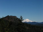
Travelling a switchback there is a big cliff off to the side which affords a great view of Mt. Adams straight ahead and Mt. Rainier and Goat Rocks off to the left. Behind is a nice pillar of rock and as a bonus, the trail soon becomes mostly level through the forest.
Enjoy the jaunt down the trail through a thick forest of Hemlock and Noble Fir with Huckleberries and Bear Grass covering the ground and in 2.4 miles, pass Cultus Lake.
For a nice side trip, turn left in .2 mile at the junction of Indian Heaven Trail and take the Lemei Trail #34 and Wapiki Lake Trail #34. In the fall, you might be able to enjoy an endless feast of huckleberries along the trail as you walk to Lake Wapiki and climb to the base of Lemei Rock. From here very experienced hikers can scramble up to the top of Lemei Rock, or just climb the gentler slopes for a view of Mt. Adams. At 5,925 feet in elevation, Lemei Rock is the highest point in the Indian Heaven Wilderness.
Back on Indian Heaven Trail head south for .4 mile to the junction of Lemei Lake Trail # 179. Take this trail south past camping spots at Lemei Lake. Continue south and cross a lovely bridge over a tiny stream and a turnpike. At the end of the turnpike, there is a surprise of a steep section of trail climbing 3 little switchbacks leading to a nice meadow then an old-growth forest. There are no views of the mountains from the meadows, but are very pretty with the fall colors.
The trail meets the Pacific Crest Trail just above Junction Lake which is 5 miles from the trailhead. Turn left to head south on the PCT, and in about 1,000 feet, keep right and pass the junction to trail East Crater Trail#48.
The PCT climbs a bit as it skirts East Crater. We noted the high spot where the land transitions over to another watershed for a side trip up to East Crater on the way back. We needed to get to the lake as early as possible to find a campsite. We gently descended through forests and meadows, passing above a small lake on the left and then came to Blue Lake on the right.
Walk a bit farther and take the trail to Tombstone Lake. The trail drops down to the okay looking lake with two designated campsites. Blue Lake is a nicer lake to camp by and the spots fill pretty quickly in the summer. There are some other lakes in the area that could provide campsites.
At Blue Lake there are some nice day use areas along the lake. We picked a spot along the lake to filter water, have dinner, and talk about the day, then went to our campsite up the hill, warming up our muscles and head for bed.
The next morning, heading back, we stopped near the high point of the trail on East Crater. From there we bushwhacked uphill and found a tiny lake. We pushed on and eventually came to a rocky slope on the southwest side of the crater. The spot we found appears to be the only spot on the crater rim with views of the surrounding hills and a meadow in the crater. The rest of the crater rim is forested.
Coming down, the conical slopes of the crater made it difficult to find where we left the trail. Picking the high point on the trail made it easy to find our packs because we just walked uphill to our packs.
We headed north to Junction Lake and continued on the PCT for another mile to Bear Lake. Bear Lake is very scenic and there are 2 campsites on the south shore and probably a couple more on the north shore. From there we continued to the Indian Heaven Trail and turned left, walking to Clear Lake for lunch. It is a beautiful lunch spot. The shore was surprisingly soggy but you can sit farther from the lake or sit on rocks at the lake. The lake is pretty shallow and the bottom not too muddy, making the lake good for wading and swimming.
We climbed and climbed up to a saddle, with the last part fairly steep, where we went off trail a bit for great views of Mt. Adams. We went further to the top but did not see any good views, only forest. I decided to name the saddle Disappointment Divide because of the limited views.
The next section of the trail is deeply rutted due to the horse traffic and lack of maintenance. The trail varies between muddy and rocky sections and descends steeply at times. There is one spot where there is a glimpse of Mt. Rainier through the trees but the rest of the trail is in the forest with an occasional glimpse of Mt. Adams.
Nearing the campground, we reached a 4-way junction with barbed wire on the left, we took a steep little way trail on the right to the campground, then walked south through the campground back to our cars.
It felt like the majority of day 2 goes gently uphill except for the last couple of miles. Be prepared for injuries. One person sprained his ankle and one person got a cut that needed to be cleaned and bandaged.
Enjoy the photos!!
Gallery Pics
Switchback Steve