June Lake Trail, WA
Vicinity location: 49 miles northeast of Portland, OR
Directions:
From Seattle take I-5 south about 150 miles and take exit 21 at Woodland, WA. Drive about a .5 mile on the frontage road and turn left at the traffic light onto State Route 503. Drive about 28 miles east through Cougar, Washington, to Forest Road 90 and another 6.8 miles to Forest Road 83, turn left onto FR83 and drive 7 miles to the turnoff for June Lake. Turn left and drive .1 mile to the trailhead parking area.
From Portland, OR, take I-205 north to exit 30b to Battle Ground. Move over to the middle or left lane and proceed north on SR503 for about 10 miles to Battle Ground. Continue north on SR503 past Chelatchie Prairie and Amboy. At the junction of Lewis River Road and SR503, turn right and continue on SR503 past Cougar. SR503 turns into Forest Road 90 just past Cougar. Drive another 6.8 miles to Forest Road 83, turn left onto FR83 and drive 7 miles to the turnoff for June Lake. Turn left and drive .1 mile to the trailhead parking area.
Note: if you are driving from Portland during rush hour, continue on I-205 or I-5 north to Woodland, take exit 21, turn right, and drive about 28 miles east through Cougar, Washington, to Forest Road 90 and another 6.8 miles to Forest Road 83, turn left onto FR83 and drive 7 miles to the turnoff for June Lake. Turn left and drive .1 mile to the trailhead parking area.
No permits needed to park at this location.
No bathrooms are available at the trailhead. The nearest bathroom is at Marble Mountain sno-park.
Length and Elevation:
June Lake – 1.3 Miles, Loowit Trail 1.6 miles from the trailhead. Total round trip is 4.6 miles measured at the turn-around point but trail 216 continues on. Elevation gain 430 feet and loss 0 feet to June Lake. Elevation gain 920 feet and loss 30 to the turn-around point. Total gain and loss is 2,400 Feet. Elevation at the trailhead is 2,730 feet, June Lake is 3,160, and the turn-around elevation is 1,900 feet.
Trail:
June Lake Trail #216B with connections to Loowit Trail #216.
There are no known geocaches along this trail at the time of this review.
Trail Maps:
Topo Map, National Forest Service Map
Review: September 25, 2010
The first thing that strikes you about the June Lake trail is the sound of rushing water from the nearby stream. The trail follows the stream for a short distance. There are a couple of views of Mt. St. Helens along the stream. The trail moves deeper into the woods and continues uphill.
The trail is a bit of a washout in places for the first few hundred feet but in most places it is a nice hiking trail covered in fir needles. The trail gains elevation at a moderate rate for the first .5 mile then climbs a bit more steeply for a about .7 mile, then levels out and has nice views of Mt. St. Helens.
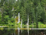
The trail follows the creek and crosses it at the just below June Lake. At June Lake you will find a waterfall that cascades onto the shore of the lake. Just past the lake the trail heads towards a steep hillside and switchbacks up the hillside. The trail was just maintained in 2010 by the Washington Trail Association. The trail steeply climbs away from June Lake, with passing glimpses of the waterfall in a steep canyon below.
The trail climbs about .3 mile in the forest and joins the Loowit Trail. Turn left here and walk generally uphill on the trail. The trail continues to gently climb through the woods for about .3 mile and comes to an old rugged lava flow from Mt. St. Helens. The trail gradually climbs up the side of the lava flow and then begins to cross over the flow. The trail here becomes very rough and sometimes hard to follow. Watch carefully for worn marks on the rocks from hikers, marker poles, and small rock cairns that people have built. Also, be sure to look back at the trail from time to time to help find your way back when you return.
The trail crosses a washed-out crossing where you have to pick you way across the streambed then continues crossing the lava flow with spectacular views of Mt. St. Helens. Continue as far along the trail as you like and then return by retracing your steps.
This trail is great for experienced young hikers. They will be challenged crossing the lava rocks and seeing June Lake. The lava flow crossings are hard on pets and not recommended.
Enjoy the photos!
Gallery Pics
Switchback Steve