Lacamas Park, WA
Vicinity Location:
The trailhead is about 14 miles Northeast of Portland, OR, on the southern shore of Round Lake.
Directions:
From Portland take I-205 North; drive past the Portland Airport Exit and cross the Columbia River. Move over to the right lane as you cross the bridge. Take exit 27 for Vancouver/Camas and move into the left lane on the off ramp.
Merge onto Highway 14 East toward Camas and drive 6.3 miles. Take exit 12 for Camas and go 1.7 miles. The road will change to NW 6th Ave. Turn Left on NE Garfield St (SR-500) Continue to follow WA-500 uphill for 0.1 mile. Turn Right on NE Everett St (SR-500) and drive .9 mile to the traffic light at NE Everett Street and NW Lake Road. Continue through this light and make the second right into the paved lot.
If this lot is full, there is a large overflow lot about 150 feet north of the main parking lot. To access this lot, drive across the lake and turn right on NE 35th Ave. Drive about 300 feet and turn left into the lot for additional parking.
There are bathrooms near the trailhead by the playground.
Length and Elevation:
3.7 miles roundtrip. Total gain is 410 feet and loss is 410 feet. Elevation at the trailhead is 185 feet, the summit elevation is 385 feet.
Trail:
Lacamas Park Trails with connections to Lacamas Heritage Trail.There is at least one geocache for this trail at: N 45° 35.835 W 122° 23.782 Info at Geocaching.com.
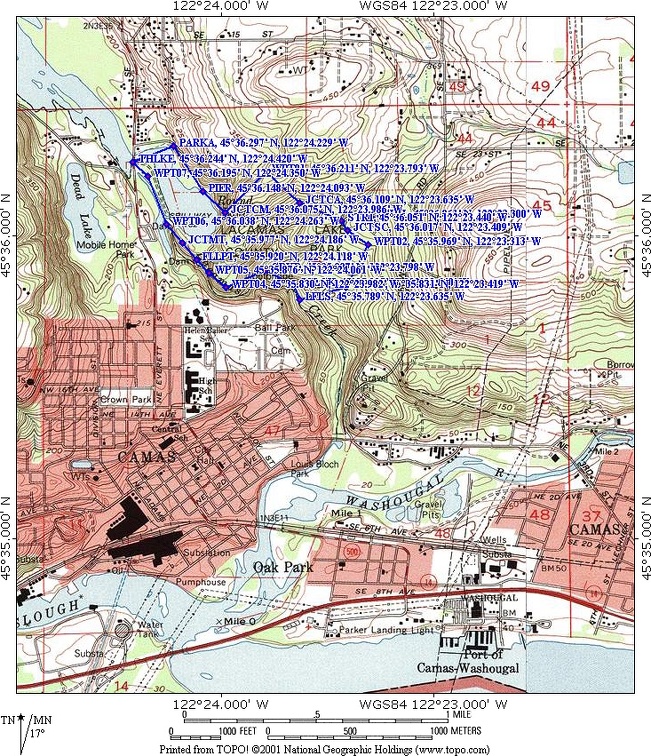
Trail Map:
Topo Map, Vancouver Parks Lacamas Lake Park.pdf, Round Lake Nature Guide.pdf, Download Garmin .gpx file, Open Garmin .gpx file
Review: July 5, 2010, May 20, 2018
The first part of the trail is the is the urban part. From the main parking lot, walk towards Round Lake and cross over the water on a footbridge. Proceed north to NE 35th Avenue, turn right, and walk on the sidewalk uphill for about .2 mile.
Turn right, enter the park and walk downhill following the lake for about .25 mile on the nicely graveled trail. This is a popular trail and you will meet plenty of people walking, jogging, or biking on the trail. The trail passes a small pier with view of the lake then the trail turns left and goes uphill. A small seasonal creek gurgles just off to the right on this uphill section.
There are numbered markers with a blue faceplate that correspond to a nature guide describing plant and animal life along the trail. Use the link in the Trail Map section and print out the Round Lake Nature Guide pdf to follow along.
After trudging up and down a couple of hills, just before the crest of a hill, you come to the trail junction to the camas fields. Make a left here and walk up the much narrower trail.
Just at the crest of this hill is a small patch of poison oak, so be on the lookout for it. Don’t sit down or stray on this part of the trail. As always, remember to make sure your pets don’t get the sap on them because it can get on you and still cause a rash of poison oak back home.The trail climbs up and crests into a nice meadow. There aren’t any views from the meadow except of the nearby Douglas Fir trees. This side trail is surprisingly rocky and has and Poison Oak sprouts in spots beside the trail. At the top, turn on the trail to the left and follow the edges of the meadow.
The trail reaches the border of the park and turns right, heading downhill into the woods. The Poison Oak quickly disappears as the woodland forest cover reasserts itself.The next junction you reach is the main trail. Turn left here and the trail will soon drop down and cross over a small creek via a wide wood-planked bridge.
The next junction goes off to the right and is Lower Falls Shortcut and you continue straight on the main trail just a few hundred feet to the next junction and turn right and follow the brown sign towards Lower Falls.
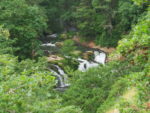
The trail goes downhill through the woods for about .3 miles and meets up with the shortcut trail. Turn to the left, then the right and head towards the noise of the Lower Falls. About 150 feet before the falls is a small trail off to the left. Follow this trail to a viewpoint of the waterfall. This is about the best view of Lower Falls.
A very short distance farther along the trail is a small waytrail that allows a slippery and potentially dangerous scramble down to the river for views of Lower Falls. Just past Lower Falls is a 4-way trail junction. Walking left, across Lacamas Creek, takes you to a bench and some picnic tables where you can have a snack and listen to the water rushing over Lower Falls.
To continue on the trail, go straight at the 4-way trail junction uphill and parallel to Lacamas Creek. After following the stream for about .2 mile, the trail goes up a small creek valley, crosses the head of the valley, then leads into the woods and soon parallels the creek again.
The next section of the trail comes out of the woods and climbs a hill with rocky outcroppings of basalt. Wherever there is rocks and sun on this trail, there is also Poison Oak. After another .3 mile, the trail comes to the overlook of Pothole Falls on Lacamas Creek. There is a reasonably good view of the waterfall a little farther.
Continue along this small side-trail and you’ll see it parallels the larger main trail which is just off to the right. In a short distance it will merge with the main trail leading back towards the parking lot. Follow the trail to the left, along the left, over the spillway, and continue around Round Lake.
Since most of this trail is in the woods and the trail is at a low elevation, this is a good trail to choose on cloudy days early in the hiking season. Because of the poison ivy and some dropoffs along a few portions of the trail, children hiking this trail should have some experience.
Enjoy the photos!
Gallery Pics
Switchback Steve