Latourell Falls, OR
Vicinity Location:
22 miles east of Portland, Oregon in the Columbia River Gorge National Scenic Area.
Directions:
From Portland, take I-84 east to the Historic Highway cutoff, Bridal Veil exit # 28. Drive about ½ mile and take the right fork to the intersection with the Historic Columbia River Highway.
Turn right and drive west about 2.7 miles. The parking lot is on the left, just before the bridge over Latourell Creek. If this lot is full, try driving across the bridge and parking along the road or take the next right and park in the Guy Talbot State Park. You can begin the loop from any of the three locations.
From Hood River, traveling westbound on I-84 from the Bonneville Dam, take Ainsworth State Park exit # 35 and follow the Historic Columbia River Highway for 10 miles to the parking area.
No permits are needed for parking.
There is a restroom in the parking lot. There is a bathroom with Flush toilets and tapwater on the north side of the road in Guy Talbott State park. The building is hidden on the west side of the park and is closed during the winter season.
Length and Elevation:
Total length is 2.5 miles for the loop. Elevation gain is 700 feet and 700 foot loss. Elevation at the trailhead is 170 feet, the high point is 700 feet.
Trail:
Latourell Falls Trail
There is at least one geocache along this trail at: N 45° 32.219 W 122° 13.225. Info at Geocaching.com
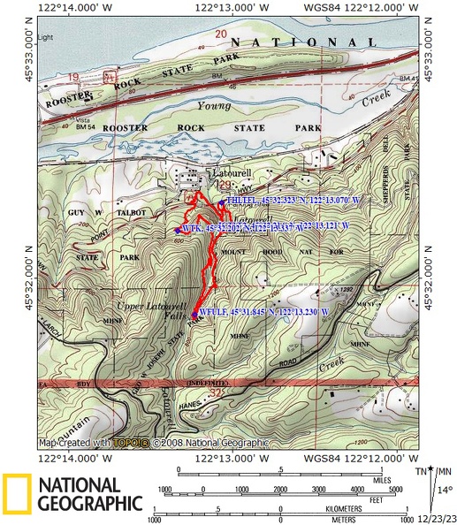
Trail Maps:
Topo Map, Download Garmin .gpx file
Review: April 8, 2008, March 16, 2014, December 21, 2023
If you need to use the restrooms right away you can take the trail at the west end of the parking lot, near the creek. The paved trail that goes to the right, goes underneath the highway bridge, and goes to the restrooms.
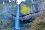
This is a fairly well maintained loop trail but it has some muddy spots during winter and spring. Start from the parking lot and go uphill to an overlook of Latourell Falls. The waterfall plunges about 250 feet into the pool at base of the falls. The falls are named after Joseph Latourell, a prominent settler in the area. The lower Latourell Falls are unique among the taller waterfalls in the Columbia Gorge because the falls drop straight down from an overhanging basalt cliff without hitting the rocks. The trail overlook provides a view of the falls. The bridge seen near the bottom of the falls is the return portion of this loop trail. Follow the trail up a couple of switchbacks as it climbs out of the canyon and above the falls. There are additional views of the falls as the trail continues upward along the east side of the creek through the switchbacks. The trail turns up the valley and follows the creek. After a about 0.3 mile there is a fork in the trail. Take the left fork. The right fork goes down to a single log crossing the creek.
There is a nice variety of flora along the trail such as cedar, maple, and fir trees. There is oxalis, coltsfoot, trillium, ducks foot, bleeding hearts, devils club, several kinds of ferns and huckleberries.
The trail winds up the east side of the valley and crosses a couple of little picturesque bridges across seasonal streams. Upper Latourell Falls is also a plunge type falls and is about 90 feet tall. It is about 8/10 of a mile along the trail from lower Latourell Falls. It is possible to walk behind upper Latourell Falls by leaving the trail and clambering over the rocks.
From the falls, the trail begins its descent along the west side of the creek. Some people venture down the steep bank and cross on an old dead log across the stream. The old log is getting rotten and is not recommended to be used as a crossing.
At the next junction, 1.4 miles from the trailhead, the trail to the right first drops down to a junction for an old creek crossing which is now closed. About 1/10 of a mile farther is a bench and a path to the right that leads to a viewpoint. The path to the viewpoint is steep, narrow, and rocky. This portion of the trail is not for children! There is no railing at the viewpoint and the cliff at the end of the viewpoint drops straight down, 250 feet, to the bottom of Latourell Falls. Do not let your children run ahead of you for this portion of the trail. If you are bringing small children on this hike you then you will want to take a left and go up the hill.
From the junction, the trail goes uphill as it comes out of the Latourell Creek Valley, turns west, and parallels the Columbia River. There is another viewpoint along the trail but the fir trees have grown to mostly obstruct the view of the Gorge. The trail climbs a little higher and then begins to gently descend. After a couple of switchbacks, the trail passes the ruins of an old water tank. The water tank must have been the source of water for the small community of Latourell. All you can see is the foundation and a few metal bands.
Early spring brings out a lot of trillium along this section of trail along with stinging nettle.
The trail continues down several switchbacks to the road through the fairly open forest. This area attracts many birds, singing their songs in the spring. Walk directly across the road go downhill along a small path down towards the park. Soon you reach a split in the path. You can go straight ahead or to the left at the first 4-way junction because they shortly rejoin and head down to the park descending some stone steps to Guy W. Talbot state park.
Go down the stone steps and continue on the trail, make a right at the next junction and the paved trail goes along the creek and underneath the highway bridge. Continue walking along the creek to the base of the lower falls. The trail crosses a bridge over the creek right in front of the thundering falls. Enjoy the mist and cool breezes then take a switchback up the bank and return to the parking lot.
Enjoy the photos!!
Switchback Steve