Lava Canyon Trail, WA
Directions:
From Portland, OR, take I-205 north to exit 30b to Battle Ground. Move over to the middle or left lane and proceed north on SR503 for about 10 miles to Battle Ground. Continue north on SR503 past Chelatchie Prairie and Amboy. At the junction of Lewis River Road and SR503, turn right and continue on SR503 past Cougar. Make a left turn on to FR 83 and follow the signs to the Lava Canyon trailhead.
A Northwest Forest Pass is required at this location.
An outhouse is available at the trailhead.
Length and Elevation:
Short loop – 1.2 Miles, Total trail one way – 3 Miles. Elevation gain 0 Feet and loss 100 feet for the short loop. Elevation gain 0 Feet and loss 1,200 to the turn-around point. Total gain and loss is 2,400 Feet. Elevation at the trailhead is 2800 feet, the turn-around elevation is 1,600 feet.
Trail:
Lava Canyon Trail, #184 with connections to Trails 184A, 184B and 225.
There is at least one geocache along this trail at: N 46° 10.156 W 122° 04.992 Info at Geocaching.com
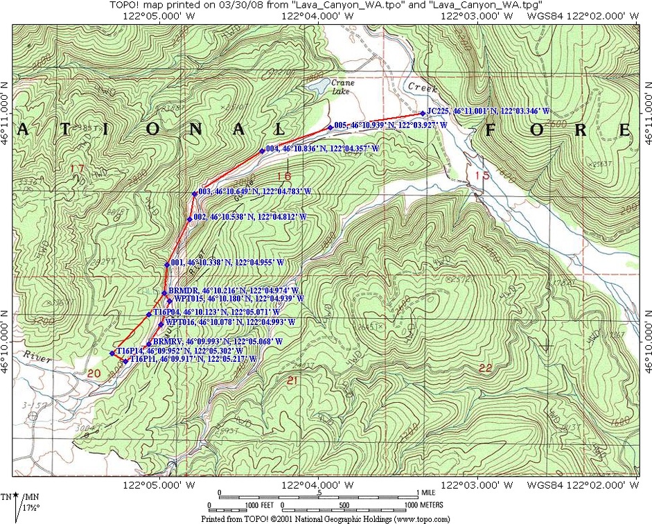
Trail Maps:
Topo Map, National Forest Service Map, Download Garmin .gpx file
Review: June 26, 2005, updated 10/5/06, 9/25/10, 9/27/20.
Trails within 10 miles of Mt. St. Helens were closed in October 2004 due to the renewed eruption activity. Most trails, including this trail, were reopened in the spring of 2005. The short loop is a very popular trail and the parking lot fills up on weekends. The Lava Canyon Trail follows the Muddy River.
The first ¼ of the trail on the east bank is paved for wheelchair access and goes to an overlook of the canyon. There are plenty of signs explaining the geologic history of the area and how the canyon was formed. Following the trail, take trail 184A, which crosses a small steel bridge across the river. There are several warning signs noting the hazards of getting off the trail. Pay attention to the warnings because 5 or 6 years ago a small child fell into the river. The father jumped in to save his son and the both perished after being swept over the waterfall. Three other people have died along this trail in the past 10 years after being swept down the slick-wall canyon of the Muddy River. One survivor who went over the falls said there was nothing to grab on to, just rushing water and smooth rocks.
The trail follows the river downstream and descends a set of metal stairs. The trail gets quite wet from seeping water and is shaded by alder trees. A short section of the trail after the stairs is bare rock sloping downhill. There is a scenic spot on the bank where you have a nice view of the river and a small waterfall. A short distance later is a suspension bridge that goes back across the river. This bridge is closed for the foreseeable future because the cables have become frayed. On the other side of the bridge is trail 184. The left junction goes back to the parking lot and to the right is the lower section of trail 184.
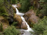
Turning left after the suspension bridge provides views of a 65 foot waterfall. Be very careful of loose rocks and cliffs if you go off-trail for a better view of the falls. Heading back to the parking lot, you might see a lot of friendly squirrels and chipmunks. They have lost most of their fear of people and scamper all around the parking lot. The upper parts of this trail are very scenic but not a good choice for small children or pets.
To the right of the suspension bridge, the character of the trail rapidly changes. In a short time the trail going down the canyon has been blasted from the cliff. This section of the trail is narrow and is not for pets, small children, or people with any fear of heights. The trail is clayey and you should stay off it if it is raining. There are a couple of minor deadfalls to negotiate but it is a spectacular little canyon with several waterfalls.
There is a steel ladder about 30 feet tall that you have to climb down, and shortly after that is a 1/8 mile spur trail to Ship Rock via trail 184B. The spur trail ends at a cliff and has a great view of waterfalls and of the ladder in the trail.
Back on the trail, you’ll cross several more little feeder streams. The trail ends at the junction with trail 225. There are restrooms at the parking lot but no water. You could easily get water from Moss Spring or filter water from one of the many feeder streams.
You physically cannot bring mountain bikes or pets on the lower section of this trail. Pets may not like walking on the metal stairs on 184A or across the suspension bridge. This is a “must” hike for sure-footed people who are not afraid of heights.
Enjoy the photos!
Gallery Pics
Switchback Steve