Lost Lake, OR
Vicinity Location: The trailhead is about 42 miles east of Portland, Oregon in the Mt. Hood National Forest.
Directions: From Portland drive east on I-84 to Hood River for about 60 miles and take Exit 62. Tturn right at the stop sign onto Hwy 30 East, Cascade Ave for 0.2 mile. Turn right onto Mt Adams Ave. As you drive 3.1 miles, Mt. Adams Drive will turn slightly right and change to Wine Country Ave and then changes again into Country Club Road. This route briefly backtracks next to the freeway then turns south and ends at the T-intersection with Barrett Drive.
At the T-intersection with Barrett Drive, turn left, and follow Barrett Drive for about a mile to Tucker Road. Turn right on Tucker which is also Hwy 281. Follow Hwy 281 as it crosses a bridge over the West Fork of Hood River. This will take you to the abandoned mill site at Dee. Take the fork to the right onto the Lost Lake Highway, and follow signs to Lost Lake. Drive about 11.6 miles and Hwy 281 turns into Forest Road 13.
There is an $8 entrance fee payable at the entry kiosk. From there, follow signs to “day use area”, and turn right at the second junction to roadside parking near the small camp store. A second parking area is located across the outlet stream, past the store.
When the resort is closed for winter you have to park outside the gate. If you want to avoid the fee, park on the road before the entrance gate and walk about a mile to the resort.
There at least one geocache along this trail at: N 45° 29.160 W 121° 49.368 Info at Geocaching.com
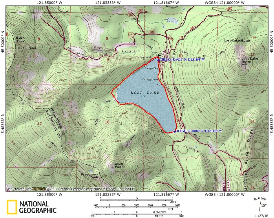
Trail Maps:
Topo Map, Download Garmin .gpx file
Length and Elevation:
3.5 miles roundtrip. Elevation at the trailhead is 3,160 feet. Total gain is 230 feet and loss is 230 feet. Highest elevation is 3,180 feet and the lowest elevation is 3,155 feet.
Review: 11/8/2016
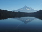
From the trailhead from the north day use parking area, find the little trail that is between the parking lot and the lake and follow it to the right, past the store. The path soon leads you across the outlet stream of the lake and through a picnic area with tables and grills. The trail is separated from Lost Lake by a narrow band of trees and it doesn’t take long before you can see Mt. Hood across the lake through the trees.
As you wind around the north end of the lake you have wonderful views of Mt. Hood and there are several places where you can drop down to the lakeshore for postcard views. When you’re looking at Mt. Hood, Butcher Peak is the little know off to the left.
Numerous seeps and streams flow into the lake along the north side. There are several marshy
areas where there are plank walk ways to keep your feet dry. Continue you along the pleasantly curving trail as Mount Hood disappears from view. After 1.5 miles the trail becomes more primitive and climbs gently up guess Model moderately up a rocky spine of the mountain and then drops back down to the lakeshore. Along the lakeshore there are very pleasant views of the surrounding the mountains. After about 2.3 miles you’re down at the far end of the lake and you come to the junction for Huckleberry Mountain Trail.
Continue on around the lake enjoying the see scenic views. Just after the junction is that beginning of the group camping area. Stay along the lakeshore trail so you can continue to enjoy views of the lake through the trees.
After about 2.75 miles you’ll pass a little building on the left and you can see that that’s the pump house and you can see the water supply line going out into the lake. After walking about 3.25 miles you come back to the picnic area and the trail turns into a paved path. It seems like you’re never far from one of the small streams that trickle into the lake. After you walk down the paved path for maybe 150 feet watch for a little trail off to the left. This will get you back onto the little trail that is closer to the lake. Following this little way trail will bring you back onto the trail from where you started.
This is a great hike for kids as there are no dangerous areas and there are plenty of views of the lake. The trail is very level except for a little rough spot at the far edge of the lake.
Enjoy the photos!!
Gallery Pics
Switchback Steve