Lyle Cherry Orchard Trail, WA
Note: 1/5/2022 – Nesting falcon advisory: A sign at the intersection near the viewpoint on the Cherry Loop alerts visitors to nearby falcon nests. Nesting birds are easily disturbed by your presence. Disturbance can cause them to fly off the nest, which can result in stress or even death of young falcons. Please be quiet and stay on the trail.
Vicinity Location:
The trailhead is about 72 miles east of Portland, Oregon in the Columbia River Gorge Scenic Area.
Directions: From Portland, OR, take I-84 East to Hood River. Cross over the Columbia River using the toll bridge and turn right on Hwy 14. Drive approximately 13 miles through Lyle.
Continue east on Highway 14. Go through two short tunnels, right next together then drive .25 mile. The trailhead is at the first gravel parking area on the left.
There are no restrooms at the trailhead. The closest restrooms are at the Lyle trailhead about 3 miles to the west of the trailhead.
No permits are needed to park at the trailhead.
Trail: Lyle Cherry Orchard Trail.
There is a geocache at: N 45° 41.169 W 121° 14.774 Info at Geocaching.com
Trail Maps: Topo Map, Download Garmin .gpx file
Length and Elevation: 5.6 miles round trip. Elevation at the trailhead is 105 feet. Elevation at the turnaround point is 1,000. Elevation gain totals 1,087 feet and loss of 245 feet one way. Total gain and loss is 2,600 feet round trip. Highest elevation is 1,125 feet.
Review: November 25, 2012.
From the unsigned parking area, switchback fairly steeply for less than .2 mile and come to the sign and sign-in area for the Cherry Orchard Trail. Fill out the release for and turn slightly to the right of the sign and travel uphill on the rocky trail through a grove of oak trees. There is plenty of poison oak along the trail so be careful when you set anything down.
Follow the main trail and continue up past some interesting basalt rocks. After walking about .5 mile, the trail comes out onto a grassy bench above the Columbia River Gorge. There are a few sparse trees scattered around. Thorny little plants grow along the trail which are a harbor for the ticks that wait for you to walk by.
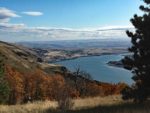
Continue up the sweeping switchbacks underneath basalt cliffs as you climb higher above the Gorge with every step. About .75 mile is a junction to a short way-trail that goes out to a nice overlook of the Gorge and a trail that heads west along the flat bench along the river. From the viewpoint you have a nice view east and west above the Columbia River. This could also be a nice place to sit down for a break on a nice day.
After walking uphill about a mile, the trail levels off and starts following the rolling contours of the hills above the Gorge. The trail weaves in and out along the edge of the cliffs and through oak forests. The tread of the trail changes from rocks to a clay soil that becomes a little slippery when wet.
Some small sections of trail are steep and the trail passes a tiny seasonal pond or wet area next to the trail. Also, be sure to check about every 10 to 15 minutes for ticks. I found a total of 7 ticks on me and my pants in late November.
Occasionally you can see metal diamond-shaped metal markers nailed to trees. After about 2 miles, the forest starts to change from the oaks to a mixture of pines and oaks and then you come to a junction with an old rutted road. Turn right here and follow the road a couple hundred feet to another junction.
When you come out of the woods, follow a small trail off to the left. Follow the trail over a grassy hill and down the slope looking for cherry trees. There is one large tree, a couple that are dying, and a couple of stumps.
Enjoy the nice views of the Gorge then walk back over the little hill to the next junction. From here, turn left and continue towards the Gorge along a jeep trail through the grass. Follow the trail through a dip then down a slope to expansive views of the Gorge to the east and west.
Return back along the road, walking past the junction to the cherry orchard, and remembering to turn left just after you re-enter the woods.
This hike is great for kids because the trail grade is moderate and there are places to rest along the way. Precautions need to be taken to deal with the high tick population. I even had a tick in my hair.
Enjoy the photos!!
Gallery Pics
Switchback Steve