
NOTE: Road restrictions and closures can occur during the winter. The highway from Longmire to Paradise may not open until 9:30 a.m. or later. Inquire about the road opening time before you go. Call 360-569-2211 and press 1, 1, 2 at each prompt. You can usually see road closures and opening times at twitter.com/MountRainierNPS
Vicinity Location:
About 15 miles east of Ashford, WA in Mt. Rainier National Park.
Directions:
From Seattle, take I-5 South to Hwy 512 East and go towards Puyallup (Exit 127). Follow Hwy 512 East for about 2 miles.
Turn south onto Hwy 7 towards Mt. Rainier. Follow Hwy 7 south to Elbe. At Elbe, turn left onto Hwy 706, travel through Ashford, and then to the Nisqually entrance of Mt. Rainier National Park. Now, follow the last paragraph of the directions.
From Portland, take I-5 North and take exit 68 to Hwy 12. Take Hwy 12 for about 30 miles to Morton. Turn left into Morton on Hwy 7 and drive about 17 miles to Hwy 706. Turn right on Hwy 706 and drive to the Nisqually entrance on the west side of Mt. Rainier National Park. The drive take about 3 1/4 hours.
Paradise trailhead:
Peak weekends: Once you are in the park, continue about 18 miles on the Longmire-Paradise Road. If you are in the park by 9am then you can follow the signs and probably park at the Paradise Inn parking lot. Barn Flats
Trailhead Parking is 2.2 miles past Narada Falls on the right. In the winter the road between Longmire and Paradise can open as late as 10am. The road opens earlier if little snow has fallen the previous night.
National Park 7-day Entrance fee of $30.00 or Annual Pass is required to enter the park.
No pets or bikes allowed on trails within the National Park.
Flush toilets available near the parking lot, near Paradise Inn and at Jackson Memorial Visitor Center.
You can see avalanche forecasts here: Northwest Avalanche Center
National Weather Service Snow Level forecast: West Slopes South Central Cascades
Length and Elevation:
4.4 miles round trip. Elevation gain 1,130 feet and loss 1,130 feet round trip. Elevation at the trailhead at 5,400 feet, highest point is at 5,800 feet.
Lowest elevation is 4,800 feet. The Jackson Memorial Visitors Center is elevation 5,400 feet.
Trail:
Paradise Valley Road, Mazama Ridge Trail, and Narada Falls Trail with connections to Barn Flats Trail. Note, these trails have different names in the summer.
Trail Maps:
Topo Map, National Park Winter Map, Download Garmin .gpx file-Early Winter Route, Download Garmin .gpx file-Late Winter Route
Review: March 24, 2012
Before going on this trip, click here to check the NW Avalanche Center or ask a Park Ranger when entering the park, at the Longmire museum, or at the visitor’s center at Paradise. If avalanche danger is higher than moderate then evaluate conditions very carefully before taking this trip. There are two small exposed slopes and one long avalanche runout encountered between Paradise Valley Road and Mazama Ridge.
When driving past Ashford keep an eye out for elk. I saw a herd of about 15 elk grazing on the left side of the road. I thought I could get some pictures but the elk turned skittish as I stopped, so I drove away so they wouldn’t run off. When I got to Longmire the road was already open for the day and the pavement looked like I didn’t need cable chains, so I drove up to Paradise.
The weather wasn’t as nice as I had hoped for but the clouds were high and the winds were low. I strapped on my showshoes and headed down Paradise Road admiring the snow clad Tatoosh mountains.
After .6 mile turn off the road at waypoint LVRD, N46° 47.408’ W121° 43.601’. The spot to leave the road and turn uphill is where the road makes a sweeping turn of about 90°, just after crossing Paradise River, and passing a small clump of trees on the left. Head up 4th Crossing Trail keeping close to the uphill trees when possible. On the way up I noticed two showshoers turning off the road before Paradise River. That route forces you to cross an avalanche slope.
I went uphill, keeping mostly to the trees to avoid avalanche danger. Continuing towards Mazama Ridge the trail passes a couple of small exposed areas and comes out to a flat area. I headed towards the trees at the end of the flat area, and then proceeded uphill to the right, towards Mazama Ridge. On the way up, I looked back and saw the 2 snowshoers heading towards me and about to cross an avalanche slope. Later in the day, I met these two snowshoers, Frank and Kip.
Walking through the small copses of trees was enchanting. A warm wind had blew the day before and made thousands of glistening icicles on all the trees. After leaving the road and walking about .6 mile I passed the trees and reached the ridge.
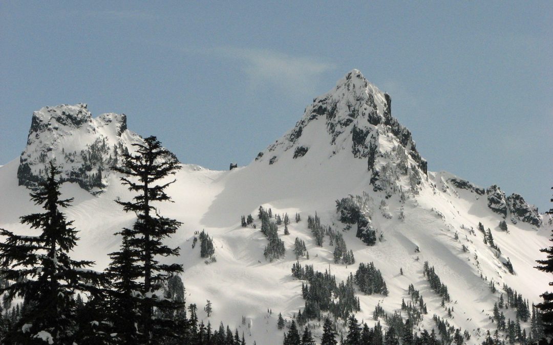
From the ridge I had expansive views of the Tatoosh Range and what I could see of Mt. Rainier. I headed down the ridge, enjoying the mountain views. The weather deteriorated a bit and it started to snow lightly. It was beautiful with filtered sun mixing with the snowflakes.
I walked generally southwest and found a place for lunch. I stopped by some fox tracks, hoping to see some wildlife. The only wildlife I saw was Kip and Frank snowshoeing down a draw towards Reflection Lakes.
I headed down towards Narada Falls, meeting several people heading up the ridge. I passed the campsite where a friend and I had been 3 weeks ago and there wasn’t a trace of our camp. The snow wall that Kevin had built was completely obliterated.
By now several people had tramped out a path down the ridge for me to follow. After walking down the ridge about 1.8 miles I reached the junction to Reflection Lakes.
From here the descent steepens down to Paradise Valley Road. Once I got down to Paradise Valley Road I used my GPS to find the Narada Trail. I had to wander around a bit, but I found the footbridge over Paradise River. I walked carefully on the untrodden snow bridge and rejoined the trail. From there I headed up to Barns Flat where I waited for the weather to clear but those stubborn clouds kept hanging around.
I walked back to the trailhead at Paradise and the sun came out. I went back down Paradise Valley Road to get more photos and met two snowshoers who offered to take my picture. It turned out to be Kip and Frank, who I had seen in the morning and just before noon.
What a coincidence that I would have seen these two men three different times in the same day. Their trip was an out-and-back to Reflection Lakes.
Enjoy the photos!!
Gallery Pics
Switchback Steve

Recent Comments