Mirror Lake, Tom, Dick, and Harry Moonlight Hike, OR
Vicinity Location:
About 45.5 miles southeast of Portland, OR. in the Mt. Hood National Forest.
Directions:
From Portland take I-84 East to the Wood Village, exit (16A). Head south and turn left onto NE Burnside Rd. Heading East, Burnside will merge into Highway 26. Follow Hwy 26. Look for the trailhead on the right side of the road about 6 miles past Zigzag.
A Sno-Park permit is required during the snow season. A Northwest Forest permit is needed in the summer months.
A bathroom is available at the trailhead.
You can see avalanche forecasts here: Northwest Avalanche Center
National Weather Service Snow Level forecast: Northern Oregon Cascades
Length and Elevation:
7.1 miles roundtrip. Trailhead elevation is 3,640 feet. Elevation gain is 1,500 and loss is 1,500. Elevation gain and loss totals 3,100 Feet. Lowest elevation is 3,580 feet. Highest elevation is 4,520 feet.
Trail:
Trail 664 – Mirror Lake
There is at least one geocache along this trail at: N 45° 17.493 W 121° 47.945 Info at Geocaching.com
Trail Maps:
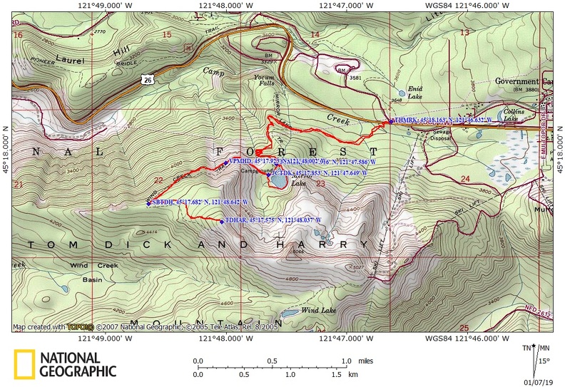
Topo Map, Download Garmin .gpx file, Open Garmin .gpx file
Review: February 18, 2005, January 2, 2019
Here is a suggestion for you. Take a moonlight hike.
Friday afternoon I drove to the Mirror Lake trailhead by Mt. Hood. I parked about 4pm and put my Forest Pass on the mirror.
Avalanche danger is low if you stick to the trail. Most of the time this trail is so packed down by the crowds that you can add microspike grips to your shoes, like YakTrax, or something similar and walk on the packed snow with no issues.
Be aware there is a short section of trail crossing slopes steep enough that avalanches could occur under the right conditions.
I headed up with my trekking poles and backpack. The trail first winds through the forest, crossing several little creeks on nice bridges and passes by bunches of rhododendrons. As you climb higher you reach several switchbacks on the way to Mirror Lake.
I made this part of the trip in about 30 minutes but I expect it would take longer if you were wearing snowshoes. The slopes are timbered with second growth trees and you can see stumps from the old growth. Some of the stumps have notches cut into them from when the loggers cut down trees by hand. The notches held springboards that the lumberjacks stood on.
Just before getting to Mirror Lake, Turn left at the junction with Mirror Lake Trail and cross on the single-log bridge over the outlet stream. Mirror Lake is frozen over this time of year and there were some old cross-country ski tracks across it. I would not recommend crossing the lake because there could be water hidden under the snow and on top of the ice. I met one other person walking and six people snowshoeing back down the trail.
There are some good views of Mt. Hood from the south end of the lake while you are on the trail that goes around the lakeshore.
There are several places with great views of Mt. Hood and early in the season there can be reflections of Mt. Hood on the frozen lake.
On the west side of the lake is the trail to Tom, Dick, and Harry peak. There is a wood trail sign on a tree just north of the little meadow on the West side of the lake though the sign is meant to be seen from the other way.
There are several campsites here but there are many less crowded and more scenic places to stay than at Mirror Lake. If you wanted to snow camp, the stream from the lake is back down the trail about 1/10th of a mile. Be aware that many people swim in this lake in the summer and people bring their small children to the lake too. You definitely want to filter water or melt snow for water.
Once on the trail to Tom, Dick, and Harry Peak the only source of water. Pretty soon the trail crosses an open slope with great views of Mt. Hood with Highway 26 below you. You lose the traffic noise as you climb higher and turn left back into the forest. The tree canopy is pretty open along this part of the trail and is less traveled than the trail to Mirror Lake.
After a while the terrain flattens out as you head towards the peak. The last ½ mile gains the last couple hundred feet in elevation, the terrain opens up, the ground gets rocky, and the trees are left behind. I read the next two peaks are closed in summer because they are peregrine falcon habitats.
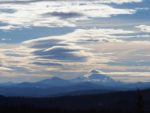
There is a great view of Mt. Hood and distant views of Mt. St. Helens, Mt. Adams, Mt. Rainier, and Mt. Jefferson. The view is well worth the climb. I had the whole place to myself and watched a fiery sunset. Night comes fast in February but I didn’t have any trouble following the trail thanks to the ¾ full moon. I stopped to take a couple of pictures of Portland lights. The moon was pretty high and lit the trail quite will through the open trees. The nighttime skiing lights for Timberline and Ski Bowl were on and I could see cars with their lights on, snaking up the highway.
After I passed back by Mirror Lake I had to use my headlamp because the trees blocked too much of the moonlight for me to see. Also the trail was a little slicker because the snow had re-frozen for the night. My foot slipped crossing the log bridge to the parking lot and I was thankful that all the bridges on the bottom part of the trail have railings to keep you from slipping into the streams.
Be sure to give this hike a try when the moon is near full and the weather promises a great sunset. The total length of this trail is about 7.1 miles and about 1500 feet of elevation gain. This is a picturesque hike during any season with a lot of beargrass and other wildflowers in the spring and nice colors in the fall. This is one of the most popular trails in Mt. Hood National Forest and planning to hike back in the dark is a great way to avoid the crowds.
Pictures of this hike
Switchback Steve