Mosier Plateau Trail, OR
Vicinity Location: The trailhead is about 65 miles east of Portland,
in the Columbia River Gorge.
Directions:
From Portland, drive on I-84 East from Portland for about 65 miles, driving past Hood River.
Take exit 69 for U.S. 30 and drive towards Mosier for .1 mile.
Turn right at the stop sign onto U.S. 30 E and drive for about 0.3 mile to the totem pole on the left side of the road near 1st Ave (Hwy 30) and Washington St.
Park along the road near the totem pole. There is ovrflow parking at the Mosier City Parking lot which is about 100 feet past the totem pole. It leads down to a gravel area between Highway 30 and the railroad tracks.
There is a portable toilet at the designated trailhead parking.
No permits are needed to park.
Stay on the trail due to sensitive plants and nearby private property. Smoking, hunting, and bicycles are prohibited.
Trail:
Plateau Trail.
There is a geocache at: N 45° 40.984 W 121° 23.410 Info at Geocaching.com
Though pets are not prohibited, they are discouraged to avoid conflicts with wildlife.
History:
In 2007 Nancy Russell purchased this 42-acre of land and deeded it to the Friends of the Columbia Gorge. Nancy founded the Friends of the Gorge in 1980.
The trail was started in 2011 and officially opened on September, 2013. The trail was built by volunteers and several groups such as Trail Keepers of Oregon , Washington Trails Association, and Northwest Youth Corps.
Trail Maps:
Topo Map, Download Garmin .gpx file
Length and Elevation:
3 miles roundtrip for the out and back trail. Elevation at the trailhead is 125 feet. Elevation gain totals 480 feet. Total gain and loss is 960 feet. Highest elevation is 580 feet.
Review: April 26, 2014, May 2, 2024
From the parking area, walk east about 300 feet, over the Hwy 30 bridge crossing Mosier Creek. Just after the bridge and on the right side of the road is a bench and the trailhead.
From the trailhead walk uphill along Mosier Creek, passing some housing units and soon thereafter walking through a pioneer cemetery and Pocket Park. Most of the grave markers in the cemetery are from the late 1800’s with some of the Mosier family buried here. In spring lilacs bloom happily here and their fragrance is delightful.
Past the cemetery you next drop down a bit and arrive at a viewpoint of Mosier Creek Falls as it tumbles down into a narrow canyon. In the summer the pool below the main falls is a popular swimming hole.
The trail drops down to an access point to the falls, then begins climbing a well maintained trail through a grassy meadow. As the trail climbs away from the creek, you go up a couple of switchbacks and a set of stairs.
In the spring, the higher you climb, the more wildflowers you see. Looking up, you may be tempted to wander off the trail to see the wildflowers. Stay on the trail because better views will soon be yours. In spring you’ll see Columbia desert parsley, yellow bells, fiddleneck, grass widows, lupine and lots of Balsamroot.
Across the river, the Coyote Wall trail is just visible on the Washington side.
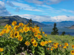
Climbing to the top of the last set of stairs, the trail becomes surrounded by wildflowers, mainly balsamroot and lupines. The viewpoint provides a
spectacular view looking west with acres of flowers in the foreground and the Columbia River flowing past basalt cliffs in the distance.
From the viewpoint there is a trail that creates a loop along the top of the
plateau. During the peak of the wildflower season the views are nothing short of spectacular and the wildflowers carpet the ground. Walk clockwise to get the best views in first. Walking along the trail you’ll pass a couple of concrete pads from demolished buildings.
The trail parallels the Gorge for a bit then meets with a gravel road. You can follow a road to Hwy 30 and return via Hwy 30 back to the trailhead, but I don’t like the idea of walking with the traffic. Instead, turn right and keep right to the road on the right which leads back to the concrete pads. From there follow the trail back down along Mosier Creek to the trailhead.
This is a spectacular trail in April. This is in my top 20 wildflower hikes for
spring because of the flowers and the views of the Gorge. If you miss the
wildflower season then plan this hike for next year. This is a great hike for
kids because if you stay on the trail, there are no unfenced cliffs.
Enjoy the photos!
Gallery Pics
Switchback Steve