Moulton Falls Trail, WA
Directions:
From Portland, OR, take I-205 north to exit 30b to Battle Ground. Move over to the middle lane and proceed north on SR503 for about 10 miles to Battle Ground. Continue north on SR503 about 5 1/2 miles further and turn right on Rock Creek Road. Follow Rock Creek Road, turning into NE Lucia Falls Road for about 5.3 miles to Hantwick Road. Turn right and follow Hantwick Road for .5 mile and turn left into the parking lot. The parking lot is closed during the winter.
No parking permits are needed.
Flush toilets are available at Moulton Falls County Park except for the winter season. A portable toilet is available at the Hantwick Road trailhead.
Length and Elevation:
2.6 miles each way. Elevation gain of 55 feet and loss of 40 feet to the turn-around point. Total gain and loss is 190 feet. Elevation at the trailhead is 515 feet, the summit elevation is 570 feet.
Trail:
Moulton Falls Trail with connections to Bells Mountain Trail.
There is at least one geocache along this trail at: N 45° 50.232 W 122° 25.770 Info at Geocaching.com
Trail Map:
Topo Map, Vancouver Parks Moulton Falls Trail .pdf, Download Garmin .gpx file
Review: June 27, 2010
The first .5 mile of the trail is paved. After walking just a few hundred feet is a small creek crossed by a concrete decked steel bridge. The trail follows the stream for a couple hundred feet and turns to the right. There is a pond next to the end of the pavement with a picnic table and overlook of the pond. The pond is about 2 acres in size and surrounded by trees. The trail passes by on the south side of the pond with trees partially obscuring the pond.
The trail is wide, well maintained, and fairly level. Soon after the pond the trail parallels the Chelatchie Prairie Railroad for about .2 mile. It is a rare day to see any rail traffic. The railroad curves off to the left and crosses the Lewis River on a trestle. The rest of the trail follows the North Fork of the Lewis River about 75 feet above the river. This area of Clark County receives over 70 inches of precipitation each year and the understory of plants reflects this near rainforest climate. There is a large patch of Sour-Apple clover (Oxalis). Be sure to sample a couple of these woodland treats.
From the wooded trail there is an almost constant view of the river through the Alder and Cedar trees. The trail is perched for much of its remaining length about 1/3 up a steep slope. The trail passes by four more streams with one stream having a small waterfall. Though there is a road across the river, it is mostly hidden from view and hardly heard. You can see houses across the river from time to time but they aren’t very noticeable.
At 2 miles you’ll pass the junction for Bell’s Mountain Trail which is the continuation of the Chinook Trail. Continue walking along the gently sloping trail up towards Moulton Falls Park and soon you will reach a spot with a good view of the river and of Moulton Falls. In the wintertime Moulton Falls is a stretch of whitewater because streamflow totally hides the waterfall as the river is funneled through a narrow rock channel.
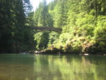
The trail climbs up to a wood arch bridge over the North Fork of the Lewis River, passing Moulton Falls. The bridge was built in 1976 and is 56 feet above the emerald colored river.
The trail drops down and passes the restrooms, then some areas where you can sit along the river. To see Moulton Falls from the north shore, continue on the trail as it parallels the road, crossing Big Tree Creek and leading to a parking lot. Moulton Falls is just past the parking lot. The Falls are only about 11 feet high.
This is a great hike or bike for children and pets. There are some steep slopes down to the river so care must be taken not to step too close to the edge of the trail. There is plenty of room to avoid the steep edge of the trail because the trail is at least 12 foot wide.
Enjoy the photos!
Gallery Pics
Switchback Steve