Newton Creek, OR
Vicinity Location:
About 50 miles east of Portland in the Mt. Hood National Forest.
Directions:
From Portland take I-84 East to the Wood Village, exit (16A). Head south and turn left onto NE Burnside Rd. Heading East, Burnside will merge into Highway 26. Follow Hwy 26 past Government Camp and exit on Highway 35 to Hood River. Follow Hwy 35 for 6.6 miles, drive under the highway overpass for Mt. Hood Meadows. Drive about 1.1 miles past the overpass and turn left into the Mt. Hood Meadows parking area, for a total of 7.7 miles from the Highway 26 and 35 junction. Drive .7 mile and turn right into the parking area for the Nordic Center.
No permit is needed in the summer months. An Oregon Sno-Park permit is required to park in the winter (Nov. 1st -thru- Apr. 30th). You can use California and Idaho Sno-Park permits in Oregon. You can use Oregon Sno-Park permits in California and Idaho. You CANNOT use a Washington Sno-Park permit.
Outhouses are available at the parking lot during the winter season.
You can see avalanche forecasts here: Northwest Avalanche Center
National Weather Service Snow Level forecast: Northern Oregon Cascades
Length and Elevation:
2 Miles, Elevation gain and loss totals 200 Feet. Trailhead elevation is 4,530 feet. Lowest elevation is 4,530 feet. Highest elevation is 4,600 feet.
Trail:
Sahalie Falls Trail #667C, Elk Meadows Trail 645 with connection to Newton Creek Trail
There are no geocaches along this trail.
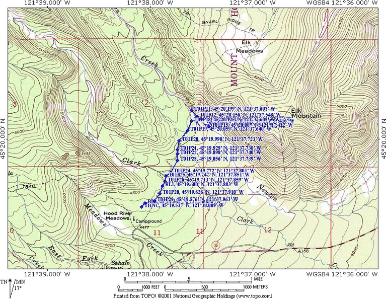
Trail Maps:
Topo Map, Download Garmin .gpx file, Open Garmin .gpx file
Review: 2/10/2009
Start on the west end of the Nordic Center trailer and ski or snowshoe to the northeast to waypoint BL0 at N 45° 19.533′ W 121° 38.081′. Look for the blue diamonds nailed to the trees, showing the trail. The forest is fairly open and it is easy to follow the waypoints to Clark Creek. The forest is mostly level with a couple of shallow ravines on the way to Clark Creek. The path heads generally northeast about .4 mile to Clark Creek.
At Clark Creek the log bridge over the creek may have too much show to cross. At the time of this review there were snow bridges just upstream of the log bridge. Continue along the waypoints, generally heading northeast towards Newton Creek.
In 2000 a flood swept down Newton Creek washing out the bridge over the creek and leaving 10 to 15 foot cliffs from the trail to the streambed. Walking a short distance up or downstream will reveal a path to the streambed.
Winter brings deep snows and create a 10 foot deep snow canyon. The snow canyon is too wide to jump across and too deep to climb down and back up again in most places. To cross Newton Creek, go back into the woods and come back out to the stream about .15 mile downstream. There is a downed log that could be suitable for a log crossing, but it seemed too risky to cross because of the tall, narrow snow bridge on the log.
I ended up digging a ramp down to a good stream crossing and shoveling my way back up and making a giant snow-step on the far side. At the crossing, it was easy to rock-step across the stream and clamber up to the top of the snowbank on the far side.
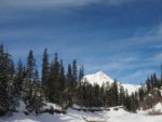
This is a good spot for a rest break and there are excellent views of Mt. Hood.
Work upstream by traversing on the uphill side of a large fallen tree, then drop down to the streambed and snowshoe back upstream to the old crossing. From here the trail switchbacks up the hillside to Elk Meadow. This is the turnaround point for this trek.
Retrace your steps, enjoying the trees, views, and streams back to the Nordic Center.
If you decide to go, make sure to be comfortable with avalanche dangers and be aware of the current avalanche dangers. Take a snow shovel so you can clean off the ramp and the giant step on the other side. If you want to ascend the switchbacks up to Elk Meadow, you will need to create 20 or 30 waypoints because you can’t tell where the snow-buried trail is as it climbs up to Elk Meadows. See the Elk Meadows snowshoe trip for the GPS route.
Don’t forget to keep separate tracks for skis and snowshoes. Don’t be a person who snowshoes over x-country tracks instead of staying out of the track.
This trail is safe for small children, as long as they are under adult supervision. Snowshoeing through the forest creates a unique set of hazards such as sharp upward-pointed sticks just under the snow, steep-sided tree wells, and empty voids covered by a thin layer of snow. The snow canyon at Newton Creek is also a unique hazard because if you get too close, the snow lip could break off and you could slide down to the bottom with no way to get out.
Happy Trails,
Switchback Steve
Pictures of this adventure here