Owl Point, OR
Vicinity Location:
The trailhead is about 46 miles east of Portland, Oregon in the Mt. Hood National Forest.
Directions:
From Portland take I-84 East to the Wood Village, exit (16A). Head south and turn left onto NE Burnside Rd. Heading East, Burnside will merge into Highway 26.
Follow Hwy 26 for 26.8 miles to Zigzag. When you drive past Welches, you are getting close to Lolo Pass Road. East Lolo Pass Road is just after the Hoodland Fire Station and Salmon River Road, which are both on the right and the Zigzag Mountain Store on the left. Turn left onto E. Lolo Pass Road and follow the twisty paved road for 10.6 miles.
At Lolo Pass turn right onto road 1810 for 7.9 miles. The pavement resumed after 5.5 miles. The road turns back into Forest Road 18 for 2.6 miles.
Make a hairpin turn to the right onto Forest Road 16 and drive 5.4 miles.
Make another sharp right onto Forest Road 1650 and drive for 3.6 miles to the trailhead at the end of the road.
No permits are needed to park.
There is no bathroom at the trailhead.
Length and Elevation:
Length 5.2 miles round trip. Total ascent 911 feet, descent 911 feet. Lowest elevation: 4,515 feet, highest elevation: 4,960 feet.
Trails:
Vista Ridge Trail #626, Old Vista Ridge Trail #626A
There is at least one geocache for this trail at: N 45° 27.325 W 121° 43.241 Info at Geocaching.com.
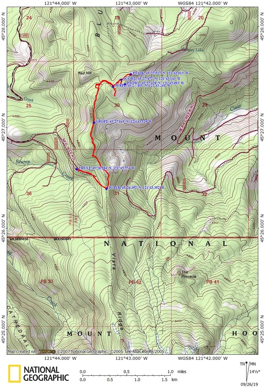
Trail Maps:
Topo Map, Download Garmin .gpx file
Review: June 9, 2019
The trail begins at the far end of the parking lot on a rocky trail in a narrow corridor of hemlock trees. The trail opens up a bit as it follows an abandoned Forest Service road. The tread soon improves to be a nice walk on a carpet of hemlock needles and just under 0.5 mile you reach the junction with the Vista Ridge Trail #626 where you turn left and skirt the edge of the Dollar Lake fire from 2011. The fire was started by lightning and burned about 6,300 acres.
From the junction and climb up a moderately steep forest for about 0.25 mile. The trail levels off for a bit as it continues along the hemlock-cone littered trail.
The trail soon climbs the ridge then levels out. Before too long there are two user trails leading off a cliff on the right that leads to a mostly obscured view of Mt. Hood. These do have nice views over the valley and a formation known as The Rockpile, off to the east.
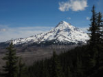
Drop down, passing through a small meadow then climb again up to the junction for the spur trail to The Rockpile. Turn right and follow this level trail out to a rocky boulder outcropping with a fantastic view of Mt. Hood. Some day the fir trees will grow tall enough to obscure the view but for now it is a wonderful viewpoint.
Back on the main trail, continue about 0.5 mile to the junction for Owl Point. It is a short walk to another outcropping of boulders called Owl Point. There are spectacular views of the north side of Mt. Hood from the boulders. There may be a metal ammo box with a summit register in it. Take a few minutes to read the notebook and find out about the history of this trail and its rescue from oblivion.
Once again on the main trail, walk another 0.3 mile to one more viewpoint, this time of Mt. Adams.
Trace your way back to the car.
Enjoy the photos!!
Gallery Pics
Switchback Steve