Ozette Triangle, WA
Unseasonably nice weather allowed this off-season trip to the Olympic Peninsula. The maxims for this trip are time and tide wait for no man and watch where you step. This is one of the best coastal backpacking trips in North America.
Vicinity Location:
About 205 miles northwest of Portland, OR and 115 miles northwest of Seattle, WA in the Olympic National Park on the Washington coast.
Directions: Drive to Clallam Bay. From Portland the drive takes about 5 hours. Driving time to Clallam Bay from Seattle is about 3 ½ hours.
Drive west 4.3 miles from Clallam Bay and turn left onto the Hoko-Ozette Road. Follow this paved road for 21 miles to the Ozette Ranger Station and trailhead.
The drive from Clallam Bay to the trailhead takes about 1 hour.
Overnight camping permits are required.
A National Park permit is required for parking. During the off-season there is a self-pay station at the trailhead parking.
As of May 2013, all food, garbage and scented items must be stored, overnight and when unattended, in park-approved Bear Canisters along the entire Olympic National Park Wilderness Coast. Buckets or other hard-sided containers are no longer permitted.
Pets, use of weapons, and wheeled devices are prohibited on coastal beaches and trails.
Campfires are prohibited between the headland north of Yellow Banks and the headland at Wedding Rocks. This includes Sand Point.
It’s illegal to touch, move, remove, or enter archeological objects and structures.
Permits for overnight trips into the Olympic wilderness backcountry are required all year. Reservations are required for overnight camping between May 1 and September 30. You can make on-line overnight camping reservations beginning March 15. The camping permit is good for the entire hiking group and costs $5, plus $2 per person per night. They are purchased at the park visitor center in Port Angeles or at the WIC in Port Angeles within the Visitor Center at 3002 Mt. Angeles Rd. or Quinault Wilderness Information Center located at the South Shore Lake Quinault Forest Service Ranger Station. Permit Link
Campfires are prohibited between the headland north of Yellow Banks and the headland at Wedding Rocks. This includes Sand Point.
Do not gather firewood from the forested areas; use driftwood only! There is little or no driftwood at Cape Alava during the summer season. Utilize existing fire rings or build fires on the beach to prevent damage to tree roots.
There is an outhouse near the trailhead. Water is available during the busy season. Primitive outhouses are available at Cape Alava and Sand Point.
Tides:
There are about 6 hours between a high tide and a low tide. See http://www.kaleberg.com/tides/alava/index.html for tide information. The lower the number for a tide, the better. On the Olympic Peninsula, tides come in only moderately fast. For this hike, you want a low tide that is under 3 feet to have time to negotiate headlands.
Trail:
Cape Alava Trail, Sand Point Trail with connections to Ericson’s Bay Primitive Trail
There are no geocaches on this route.
Trail Maps:
Topo Map, Download Garmin .gpx file
Length and Elevation:
Day 1: 8.2 miles, elevation gain of 300 feet, elevation loss of 380 feet.
Day 2: 6 miles, elevation gain of 100 feet, elevation loss of 100 feet.
Day 3: 6.3 miles, elevation gain of 200 feet, elevation loss of 120 feet.
Total mileage 20.5 miles, total elevation gain 600 feet, total elevation loss 600 feet.
Trailhead elevation: 80 feet, highest elevation 200 feet, lowest elevation: 0 feet along the coast.
Review: February 21, 2015
From the trailhead at the outlet of Lake Ozette, cross over an arched footbridge and, gently climb for about .25 mile to the junction for Sand Point and Cape Alva. At the junction we turned right towards Cape Alva. The trail gently slopes down for a while from the junction along a well graveled trail, passing beneath Sitka Spruce, hemlock and cedar trees with an undergrowth of evergreen huckleberries, salal, ferns, and lots of moss.
Soon you come to a section of trail consisting of boardwalks across the wet areas. Some of the boardwalk is newer and made of a composite material and other sections are made from wood which becomes slippery when wet. Johnny’s girlfriend slipped on the boardwalk a couple of years ago and broke her ankle. Another person broke their ankle on the same day and had to be carried out.
At 2.25 miles pass through Ahlstroms Prairie where homesteaders made a living in the early 1900’s. Most homesteaders left by the 1940’s due to there being no road to the area. The trail winds through the old growth forest and after a few miles drops down to the beach. There were many campsites to choose from and we found a campsite right by the beach. We had enough time to walk north on the beach and explore. There is a decrepit building and a nearby shed with Makah stuff in it. We didn’t touch anything and walked on up the beach. Johnny and I walked north to the mouth of the Ozette River and had to use ropes to pull ourselves up the hill and let ourselves back down the other side of a headland along the way.
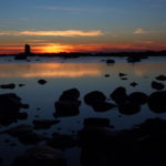
The river had a strong flow and we were glad that we didn’t have to cross it for our trip. I’m sure the river is much calmer in the summer. On the way back we were treated to a beautiful scene as the sun set behind the stone pillars and haystacks just off shore.
Back at camp we got a fire going as there was plenty of driftwood early in the season. The shore and reefs are very shallow here and the surf goes from right next to the beach and maybe 500 feet from the beach. I used my earplugs for when the surf was close but all was quiet at low tide.
We broke camp early the next morning to coordinate with the tides. We walked south, admiring the sea stacks and wildlife. We saw deer, eagles, ravens, and osprey. Other people have seen otters and whales near shore. The beaches along this stretch are mostly pebbles, gravel, or rocks and there are places where spruce trees have toppled and point out to sea. Negotiating these during low tide means walking on slippery kelp covered rocks and near high tide you would have to climb over these very large trees.
About 1.2 miles from camp, we made it to the headland of Wedding Rocks. We took time to find some of the petroglyphs made by Native Americans. They are located among the rocks right near the high surf line. This headland has to be negotiated before the tide comes in past 5 feet.
We continued around the large bay for .5 mile following the rocky coastline. There is another headland that has to be negotiated before the tide comes in past 5.5 feet.
We approached Sand Point and took the overland trail to get around the next headland in time. We came out to a driftwood filled shoreline with a long sandy beach sloping out to the ocean. Walking on the sand closer to the ocean was easier to walk on. We enjoyed all the different patterns in the sand from water and sand shrimp. We passed a nice campsite along the way where we met some surfers who carried in their boards for the weekend. We continued along the beach and the sand turned into gravel, then rocks, then a headland. Rocky Point headland has to be negotiated before the tide comes in past 5 feet. At one point the headland juts out quite a bit with some tidepools. We looked to the left and saw where people had gone up and over the rocks and through the trees to the next grotto carved by the ocean. Once you get to this final obstacle the headland is either negotiated through a little tunnel or going around on the uneven and slippery rocks. Even though the tunnel is narrow, it is the preferred way but you might have to take off your pack. From there it is another little scramble over the rocks then you drop down to the beach at Yellow Bank. It becomes hard to keep your feet dry getting onto the beach once the tide gets past 6 feet. For us, this was about an hour before a high tide of 8.3 feet. If you can’t get past this headland, you will have to wait out the tide because there is no overland route because of the cliffs on the Yellow Banks side.
We walked onto the beach for Yellow Banks. We looked at the different campsites along the beach and chose the first one. We found good water about .25 mile farther down the beach. It is about the only stream that isn’t brown. I chose a spot on the rocks at the top of the beach. The flat stones ended up being surprisingly comfortable with my little ¾ length pad.
We tried to leave about 8 am for the tides and because of the long drive back. We saw several eagles on the beach and in the trees coming to Sand Point. From the top of Sand Point we saw more eagles and ravens just waiting for a fish to swim by.
Taking the Sand Point Trail back to the parking lot, a lot of the trail is boardwalks. Sections of boardwalk are being replaced by gravel turnpikes which are much nicer to walk on. Walk through nice cedar forests and an area where a fire killed all the trees and now the silver ghosts stand among new trees. The last part of the trail passes from the wetlands into a forest of cedars, hemlocks, and Sitka Spruce trees. The last part of the trail is a gentle descent back to the Ozette River, over another little stream, and back to the parking lot.
If you are squeamish about your water, this trip is not for you. Nearly all of the streams are brown from the tannins in the water. The water needs to be filtered before drinking and tastes pretty normal but the water is brown even after filtering. The boardwalks are slippery and a heavy step could plunge your foot through a rotten board.
Enjoy the photos!!
Switchback Steve