Paradise Valley Road Snowshoe, WA
NOTE: Road restrictions and closures can occur during the winter. The highway from Longmire to Paradise may not open until 9:30 a.m. or later. Inquire about the road opening time before you go. Call 360-569-2211 and press 1, 1, 2 at each prompt. You can usually see road closures and opening times at twitter.com/MountRainierNPS
Vicinity Location:
About 15 miles east of Ashford, WA in Mt. Rainier National Park.
Directions:
From Seattle, take I-5 South to Hwy 512 East and go towards Puyallup (Exit 127). Follow Hwy 512 East for about 2 miles. Turn south onto Hwy 7 towards Mt. Rainier. Follow Hwy 7 south to Elbe. At Elbe, turn left onto Hwy 706, travel through Ashford, and then to the Nisqually entrance of Mt. Rainier National Park. Now, follow the last paragraph of the directions.
From Portland, take I-5 North and take exit 68 to Hwy 12. Take Hwy 12 for about 30 miles to Morton. Turn left into Morton on Hwy 7 and drive about 17 miles to Hwy 706. Turn right on Hwy 706 and drive to the Nisqually entrance on the west side of Mt. Rainier National Park. The drive take about 3 1/4 hours.
Paradise trailhead:
Peak weekends: Once you are in the park, continue about 18 miles on the Longmire-Paradise Road. If you are in the park by 9am then you can follow the signs and probably park at the Paradise Inn parking lot. Barn Flats Trailhead Parking is 2.2 miles past Narada Falls on the right. In the winter the road between Longmire and Paradise can open as late as 11am. The road opens earlier if little snow has fallen the previous night.
National Park 7-day Entrance fee of $30.00 or Annual Pass is required to enter the park.
No pets or bikes allowed on trails within the National Park.
Flush toilets available near the parking lot, near Paradise Inn and at Jackson Memorial Visitor Center.
You can see avalanche forecasts here: Northwest Avalanche Center
National Weather Service Snow Level forecast: West Slopes South Central Cascades
Length and Elevation:
4.3 miles round trip. Elevation loss is 550 feet to Paradise River. Total elevation gain and loss is 1,100 feet. Elevation at the trailhead at 5,400 feet, highest point is at 5,400 feet. Lowest elevation is 4,850 feet. The Jackson Memorial Visitors Center is elevation 5,400 feet.
Trail:
Paradise Valley Road and Narada Falls Trail and Barn Flats Trail with connections to Mazama Ridge Trail. Note, these trails have different names in the summer.
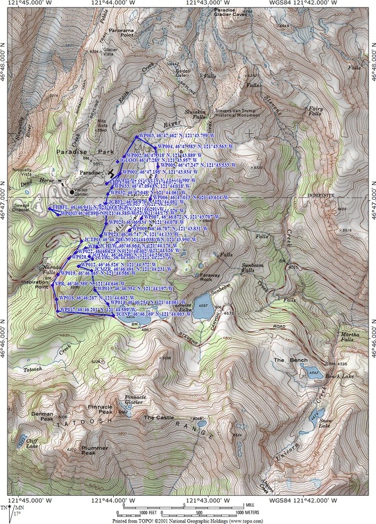
Trail Maps:
Topo Map, National Park Winter Map, Download Garmin .gpx file
Review: March 6, 2011
From the visitors center, walk east, downhill, to the southeast end of the parking lot. Climb up the snow berm and follow Paradise Valley Road downhill for 1.9 miles. At the junction turn left on the Mazama Ridge Trail and go uphill about .4 mile.
At the junction for the Mazama Ridge Trail, keep right to go down the ridge to Reflection Lakes. The trail that continues up Mazama Ridge is unmarked and is sometimes has no track.
The forest opens up as you drop down to Reflection Lakes. On clear days there are great views of the jagged Pinnacle Peak right in front of you.
Once down to Reflection Lakes you can walk where the road is, or around the edges of the lake. Though the lakes are frozen, safety suggests not walking far from the shore as a rescue would be a long time arriving.
Return the same way back up to the junction for Mazama Ridge and turn left to descend towards Narada Falls.
This next part of the trail changes depending on snow conditions. Early in the season the trail continues straight at the junction with Paradise Road and then the trail drops down, crosses Paradise River over a footbridge. From there the trail climbs fairly steeply for about .25 mile to Barn Flats.
Later in the season the trail continues towards Narada Falls and adds an additional .4 mile to the length of the trip. The trail drops down to Stevens Canyon Road and heads northeast. Look for signs for Paradise. Follow the trail uphill about .4 mile to Barn Flats.
There are more great mountain views from this section of the trail, so be sure to turn around for more views of the Tatoosh.
Continue about another .35 mile across the flats and up a gully back up to Paradise Valley Road.
If the mountains are out, take in great views from the snow banks along the parking lot. Finally, walk a few hundred feet back into to the parking lot.
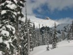
Enjoy the photos!!
Gallery Pics
Switchback Steve