Pacific Crest Trail – Little Crater Lake to Jefferson Park
Note 2/14/2023: During summer and fall a Central Cascades Wilderness Permit is required. The Central Cascades Wildernesses limited entry system began May 22, 2020 and brings day-use limits to 19 out of 79 trails and overnight limits to all trails in the Mt. Jefferson, Mt.
Washington and Three Sisters Wilderness.
Vicinity Location:
Little Crater Lake is about 52 miles Southeast of Portland, OR in Mt. Hood National Forest.
Directions:
Little Crater Lake Trailhead: From Portland take I-84 East to the Wood Village, exit (16A). Head south and turn left onto NE Burnside Rd. Heading East, Burnside will merge into Highway 26. Follow Hwy 26 to Government Camp.
There are bathrooms and water at the Little Crater Lake trailhead. There is no bathroom or water at the Whitewater River trailhead.
A permit is needed to park. A free wilderness permit is filled out near the trailhead. A permit is needed to camp in Jefferson Park between Memorial Day and October 31st – link
Trail:
Pacific Crest Trail #2000, Whitewater Trail #3429 with connections various other trails.
Trail Maps:
Topo Map
Length and Elevation:
51 miles one-way. Elevation gain of 7,500 feet and loss of 6,600 feet. One mile side trip to Mt. Jefferson, elevation gain of 1,400 feet and loss of 1,400 feet roundtrip. Elevation at the Little Crater Lake trailhead is 3,245 feet. Elevation at the Whitewater trailhead is 3,000 feet. Highest point on the trail is at 6,900 feet. Lowest elevation is 3,000 feet.
Day 1 – Little Crater Lake Campground to Dry Camp: +500, -250, 7 miles.
Day 2 – Dry Camp to Seeping Spring Camp: +1,400, -1,000, 9 mles.
Day 3 – Seeping Spring Camp to Jude Lake: +2,300, -1,500, 14 miles.
Day 4 – Jude Lake to Breitenbush Lake: +1,700, -800, 9.5 miles.
Day 5 – Breitenbush Lake to Scout Lake: +1,400, -1,100, 6 miles.
Day 6 – Day hikes: +1,400, -1,400, 2 miles.
Day 7 – Scout Lake to Whitewater Trailhead: +200, -1,970, 4.6 miles.
Review: July 6, 2003.
50 Mile Hike on the PCT – Little Crater Lake to Whitewater Trail
I had been planning this trip with the Boy Scouts for several months. The schedule was to leave in early July, which ruled out a lot of trails because of snow. I needed to find a location within a reasonable length drive for someone to shuttle us to the trailhead and back again. I also wanted a scenic hike without thousands of feet of elevation gain. I decided on the Pacific Crest Trail in Oregon. I had hiked part of it in the past and I knew the trail wouldn’t be unreasonably steep. I wanted to make sure we hiked 50 miles and looked for places to end our hike. I saw the Whitewater trail out of Mt. Jefferson Wilderness was a good ending spot. That would make the last day mostly downhill. Other possible locations were a loop on the eastside of Mt. Rainier National Park and the Northern Loop in Mt. Rainier National Park. As I analyzed these other trails, I decided there was too much elevation gain and too much snow early in July to make these trips successfully. I made my suggestions to the troop and we agreed on hiking the PCT from near Timothy Lake to Jefferson Park in Oregon. We had one scout drop out due to scheduling conflicts and two scouts decided not to come because their schedule was too busy.
The week before the trip, we met at Mr. Gourlie’s house and brought along everything we intended to wear and pack. We talked about how much fuel to use and how much food to bring. I estimated each person needed about 1 ¼ pounds of food per day. If we were running way low on food then we would be able to buy extra at the lodge on day four. The Scouts shared a stove and a 4-person tent that weighed about 10 pounds and my tent, which Mr. Gourlie and I shared, weighed about 6 pounds.
It was a misty Sunday morning when we left our house on July 6th. We arrived at the Home Depot, which is north of Orchards, at 8:30 am. When we got there, we saw a ferret running around the parking lot. The other backpackers soon arrived and Cedric drove us to our trailhead at Little Crater Lake. The closer we got to the trailhead the better the weather got. By the time we were dropped off the sky was perfectly clear. We took pictures of us five intrepid hikers, had some snacks, and said goodbye to Cedric. We were alone and on our own. I felt a little overwhelmed and worried if I’d left anything important behind.
The trail soon turned into a boardwalk across marshy ground. In about a quarter of a mile, we came to Little Crater Lake. A sign explains how a geologic fault and gravelly soil conditions have made a small lake, which is about 20 feet deep with the edge of the lake dropping straight down to the bottom. The water was a beautiful turquoise and a sign explained the water temperature is always 34 degrees. Soon after passing the lake, we joined the PCT and tuned south. The trail is in deep forest and looks well traveled. You could see bicycle tire tracks on this part of the trail though it is not permitted.
In a couple of miles, we reached a stream that flows into Timothy Lake. The lake is a beautiful blue color and the weather was perfect with blue sky and a light breeze. We saw five swimmers at one point along the lake. We passed several nice campsites which would be accessible by hiking a few miles north from Timothy Lake. We saw several boats on the lake and I wondered if motorboats were allowed. My question was soon answered when I heard a gas powered motorboat on the lake. About 12:30, we followed a path down to the lake and had lunch. Mr. Gourlie remarked that if we were in Eastern Washington there would be a lot of rattlesnakes in all the rocks. We filtered water and finished lunch. The trail became dustier as we passed around the south end of Timothy Lake. Usually the breeze kept the dust-clouds away from us but sometimes the dust swirled around us. The trail remained fairly level throughout the day. We passed a junction to the historic ranger station at Clackamas Lake and the trail passed the southern end of Timothy Lake. The trail climbed gently upward and we passed by the spot where I thought there would be water. We reached Wilson Road and we were almost out of water. The map showed a stream crossing the road. We scouted around for water but only found a dry streambed. We decided to backtrack, set up camp, and backtrack further to find water. Tyler was discouraged but we found an adequate but dry campsite in about a mile. We made camp, hung up our food, and then went for water. Back at the junction, we turned left and soon saw Clackamas Lake. We headed towards the lake and found a trail that led to prolific springs that fed the lake. Tyler accidentally sat on an ant nest while he filtered water. He really jumped when he saw them crawling all over him. We filtered 12 liters of water and hoped to have enough water for the next day so we wouldn’t have to hike back to the springs again in the morning. We got back to camp and fixed our dinners. We retired early to the tents because there were lots of mosquitoes. We had seen a total of four hikers today. Lance, Tyler, and Vernon cracked jokes and did other things that 13 and 14 year old boys do. Other than having to backtrack, this was a wonderful hiking day. The sky was blue and the temperatures were in the mind 60’s. The Scouts are getting along well together and Mr. Gourlie and I are quite comfy in the two-man tent. We hiked a total of about 12 miles the first day.
I got up about 6:30 am on July 7th. I could hear different birds enjoying the clear dawn. One woodpecker sounded musical tapping on a distant tree. We had suspended our food between two trees the previous night. I was glad to see it was untouched. Pretty soon, I hunted out my hat and gloves as it was jut below 40 degrees in the camp and I was getting cold. I got the food down out of the tree and waited awhile before I started waking people up. We made breakfast and then broke camp. We decided that we had enough water to go forward and that there was no need to backtrack to the springs where we had filtered water yesterday. We all hit the trail about 8 am and found the place where we turned around the previous day at about 8:30am.
The trail climbed steadily from the road crossing. The trail was pretty shady and the dust got less as we gained altitude. We passed under crackling power-lines that had towers so tall the lines were way above the treetops. After a mile or so, the trail started dropping down to the Warm Springs River. We met two hikers who told us how nice the Warm Springs River was. When we reached Road 4245 Mr. Gourlie needed to change out of his boots. He thought he had broken-in his boots by wearing them around the house but it was a different story once he started carrying a heavy pack. His boots had been hurting the tendons on the sides of his ankles for some time. He had tried using gloves for padding but it wasn’t helping enough. He changed into his Teva river shoes and we continued through the forest. Soon the kinds of plants were changing to what you would see near a river. I had some concerns about getting across Warm Springs River. I’ve seen the river on the way to Bend, Oregon and it is quite a large river. Just before we got to the river, we saw a deer in a meadow. We watched it for a short time before it walked into the woods. We made a sharp descent down to the river and it was only 20 feet wide and about 12 inches deep. There was even a log bridge over the river. It was about 12:30 so we stopped for lunch and soaked our feet. Brrr the water must have been about 35 degrees or colder. While we were having lunch, we noticed a bunch of butterflies landing on a sunny part of the moist riverbank. I walked over and nudged one to onto my finger. It seemed to be looking for something to eat. I put some water on my finger and it lapped it up. I showed Vernon and he got a butterfly to crawl onto his finger too. Lance was moving too fast and they kept flying away from him. Once he slowed down, he could get one too. Pretty soon, Tyler had a couple on him and later he had five on him. It felt weird when they flew around your head and ears. One tried to fly up Lance’s nose. We stayed there for an hour before we left for the long climb south out of the valley. I was getting worried that I would miss where we were planning to camp for the night. I was worriedly scanning the trail for a sign or side trail for the camp. Relieved, I finally saw rocks marking small side trail. Lance and I went down the trail and when I saw the campsite, I knew we would be okay. We found the seeping spring and the water barely flowing from it. We set up camp and the boys started a fire right away. We set up our tents and then Mr. Gourlie and I moved our tent to a level campsite about 50 feet uphill from the fire ring. I found a giant cricket near the fire ring. It was about 1 ½ inches long and ½ an inch fat. It was so big it could barely hop. Speaking of hopping, we found a frog in the spring. We were happy to eat our dinners while sitting around the fire. Vernon was very interested in anyone’s leftovers. We started our after dinner chores and it was a lot of work to get our food bags suspended. After several tries of getting the bear rope into the trees, we got the food bags about eight feet off the ground and hoped it would be high enough to keep it from any varmints.
I noticed thin high clouds in the sky. They were the first clouds we had seen on our hike. I could hear the crickets chirping near our tent. I wondered what change in the weather the wind and clouds would bring in the morning. There were fewer mosquitoes than last night’s camp but they were still plentiful. Tomorrow there won’t be any water available for the whole day and there is over 1200 feet in elevation gain. We hiked almost 12 miles on our second day.
I awoke to the sound of wind in the trees and temperatures in the high 40’s on July 8th. I went over to the Scouts’ tent and woke them up by loudly rattling their Tyvek ground tarp. I brought down the food bags and set them next to the fire-pit. After breakfast we took plenty of water from the spring because there wouldn’t be another source of water until Trooper Spring, which was about 8 ½ miles away. We packed and left camp about 7:30 am. The trail climbed steadily and by 8:30, Vernon was begging for part of the beef sausage I’d brought along. By 9:30, I’d given him his half and he hungrily began devouring it. I didn’t think the sausage would last for long.
We continued to climb the trail and were moving pretty well until we hit the switchbacks. Every time we stopped to rest, the mosquitoes urged us on. The trail hadn’t been cleared yet and we had to negotiate quite a few fallen trees. We passed breaks in the trees that our guidebook said had great views of Mt. Hood but all we saw were clouds and fog. We passed a tree that had been shattered by lightning. There were giant splinters that had been thrown dozens of feet away from the tree. Mr. Gourlie took some pictures of the devastated tree. As we continued hiking the lightest of mists was falling and we wondered if the rain had arrived. We met two hikers as we passed the Pinhead Buttes. They were hiking about 55 miles from Olallie Lake to Timberline Lodge. We realized we had blasted by our 1200 foot elevation gain and it looked like we would reach our campsite shortly after lunch. We took a break about noon and Trooper Spring was only ¼ mile away according to my GPS. We reached the spring about 12:30 and had lunch among the mosquitoes. We talked and decided to push on to the next night’s campsite which was about 6 ½ miles away with another 300 feet in elevation gain. Vernon and I grew tired and lagged behind. After a couple of hours we heard that Mr. Gourlie’s feet were getting really sore from wearing his river shoes. The pace slowed and we caught up once the trail started heading back downhill. The trail crossed several rocky sections which made Mr. Gourlie go very slow. We made several rest stops and late in the afternoon we found a wonderful campsite on the southern shore of Jude Lake. During the afternoon the clouds had burned off and the weather had turned sunny. Lance made new friends with the carpenter ants and had one crawling over his hands. Most of us got into the lake to clean up a little. There were dozens of salamanders in the warm lake water. The bottom was pretty muddy and you had to be careful not to get tangled in the underwater weeds. Later, I started a campfire and boiled water for our noodle dinners. Mr. Gourlie and Lance had spaghetti with meat sauce and Tyler had Turkey Noodle. After dinner we sat around the campfire and turned in early because we were all tired. Mr. Gourlie is going to try his boots on again tomorrow because his toes are so tender from walking in his river shoes. He fears he has bruised his toes enough that he will lose some toenails.
Everyone hiked really well today. We covered over 14 miles and over 2000 feet in total elevation gain. Tomorrow we’ll decide how far we want to hike.
July 9th I woke up at 12:30 am and it seemed pretty warm outside even though the stars were out and the sky was clear. I woke up again about 5:30 am to the sound of a bird fluttering just outside the tent. I got up and the air was perfectly calm and the lake had mists slowly moving across the water. I filtered water for breakfast as I sat on a log bridge at the west edge of Jude Lake. I went back to camp and had to try four times before I got the fire started. I must be really out of practice. The others soon got up and I cooked oatmeal over the fire while Mr. Gourlie heated water for himself, Lance, and Tyler. Mr. Gourlie had modified his boots at the start of the day by lacing them up halfway and tying open the tops of his boots. We talked about hiking to Horseshoe Lake for our destination that day and headed off towards Olallie Lake Lodge. The Scouts zipped down the trail with visions of buying candy bars and sodas at the lodge. We reached the lodge a little after 10 am and bought candy bars and sodas along with hot dogs and buns for the night’s dinner. Tyler was going to call home from the lodge but they were charging $5 for a five minute call. At the lake, Mr. Gourlie met someone he knew from the Hood –to-Coast races. His name was Vic Carlson and he was with a group of Scouts who were hiking from Horseshoe Lake to Scout Lake in Jefferson Park for an overnighter. One of the men in his group tried to use his cell phone to call home for Tyler but the call wouldn’t go through.
After our sugar hit, we reached consensus to continue hiking towards Horseshoe or Breitenbush Lake. The trail was rocky and started climbing steadily. We reached Cigar Lake and had lunch. The mosquito population had slowly been increasing which caused our breaks to be short. We climbed a really steep part of the trail and came to a fantastic viewpoint of Mt. Hood and Olallie Lake. The lake was far below us and far away. The trail had been pretty rocky all morning. After we left the Many Lakes Viewpoint the trail was level for awhile and then started climbing again. Everyone was tired but kept pressing forward because of the mosquitoes. The trail climbed up and up and finally broke out onto a rocky slope with an incredible view of Mt. Jefferson and the Breitenbush River. We stopped for some pictures and then climbed up another ¼ mile and crossed a couple of snow patches. The bugs finally let up and then we descended down towards Breitenbush Lake. We found a great looking campsite but it was filled with mosquitoes. We tried another spot and it is almost as bad. We swatted at the mosquitoes constantly and the Scouts went wading to try to escape the bugs. They found the lake bottom really muddy and there was some flailing of arms as the Scouts worked to keep their balance. Once out of the lake we got the fire going for the hot dogs. I couldn’t find any willow or alder branches but I did find some weathered cedar branches to skewer the hot dogs. We cooked our hot dogs over the open fire while we swatted mosquitoes. We just couldn’t put on enough repellant to keep them away. We hung up the food for the night and got into out tents by 6:30 pm. Later the Scouts got back out and filtered water for the next day. We were all entertained by the mosquito bite tally. Vernon had 135 bites, Tyler 41 bites, and Lance was the winner with 219 bites.
In the tent the Scouts recounted Harry Potter books and Tyler had to keep protesting that he didn’t want to hear how the latest book had ended. Mr. Gourlie and I talked about our families and jobs we had done in the past. We went to sleep about 10 pm with little clouds of you-know-whats circling above our tents leaving no doubt we would be leaving camp early tomorrow.
Late that afternoon a truck had pulled into the otherwise empty campground. We were surprised the next morning to see that they had stayed the night. We hiked about 11 miles on our fourth day.
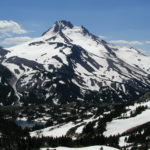
July 10th found me awake at about 6:45 am. The sun was just rising across the lake. It was another perfectly clear day. I dressed and headed down the lake for some pictures of the lake with Mt. Jefferson in the background. I followed an old trail for awhile and then went down to the lake for pictures. When I got back to camp the mosquitoes were almost as bad as the day before. Mr. Gourlie and I were kind and let the Scouts eat in the tent. After breakfast we filtered water for the day. I looked for a place where there were less mosquitoes to filter water. There were hundreds of mosquitoes that soon swarmed me and I my filter plugged with silt. I hurriedly went back to the bridge, cleaned my filter, and got some water. I didn’t discover until much later in the day that I had left behind the bottom cap to my filter when I ran away from all the mosquitoes. We headed out about 8 am and stopped at the outhouse for our morning constitutional. The trail was uphill immediately from the lake. Mr. Gourlie ran into Vic Carlson from Troop 119 again. Vic told him that they had lost the trail, had camped along the trail on the snow last night, and were coming back. That worried us a bit but we were ready to take on the challenge. We hiked upward and started encountering small snow patches. The snow got deeper and the patches got a lot bigger as we slogged upward. We stopped at the first really big snowfield and consulted our map and GPS. We sighted a distant landmark that the trail passed, took a bearing, and headed across the snow. We found the trail again after several minutes and saw there weren’t any tracks from yesterday. The snow was just right for walking on. It wasn’t icy and it wasn’t too soft. We continued across several more large snowfields and found the trail again each time using our orienteering skills. The views kept getting better and better as we approached timberline. About 10:30 we found a neat campsite and the Scouts set up their tent and we began to explore the area. I got some great pictures of the scenery and the Scouts broke icebergs in the lake next to camp. The icebergs made great targets to throw rocks at. The mosquitoes were pretty bad but tolerable. I found a slope for the Scouts to go sledding on and we used the Tyvek ground cloth from the tent for a sled. While we were sliding down the hill we met a woman who was hiking with her dog from Mt. Bachelor to the Columbia River. I asked about mosquitoes at Scout Lake and she said there weren’t any. That was good enough to make us decide to move camp. We ate lunch in the tent to avoid the mosquitoes, packed up the Scouts’ tent and took off. The views became better and the snow fields more frequent the higher we went. We spotted some rock cairns, old footprints, and occasional patches of the trail. At about 1 pm we reached the high point of the trail at 7,010 feet. The views were spectacular. We saw Mt. Jefferson to the south, Mt. Hood, Mt. Saint Helens, and Mt. Adams to the north. We left our packs by the trail and climbed another 200 feet to an unnamed peak. It was hard to believe how beautiful the panoramic views were. The only thing higher that we could see was Mt. Jefferson. We stayed in the area for an hour then began our descent down the rocky trail to Scout Lake. There was still a lot of snow on the trail for the next mile. We stepped over many snow melt streams and passed small fields of wildflowers. A lot of the streams ran down the trail then went on down to the valley. We passed Russell Lake which looked like it had just melted out. We continued to have incredible views of Mt. Jefferson and Park Butte. We reached Scout Lake about 3:30 pm and we were tired but happy. We checked out several of the campsites around the lake and then eliminated some because of the camping rules. One of the rules is that if you camp closer than 250 feet to the lake then you have to tent within 15 feet of a designated camping marker. Another rule is no campfires in Jefferson Park. We ruled out a couple of campsites because there was melting snow and big puddles in them. We set up camp near the lake and discovered there were mosquitoes at Scout Lake even though snow went right to the edge of the lake. The Scouts entertained us all by counting their mosquito bites again. Lance had 219, Vernon had 135, and Tyler had 41.
We fixed dinner and Tyler only had a little bit of leftovers that night. This made Vernon very disappointed as he had been taking care of leftovers throughout the trip. I saw that my food was getting used as planned and I didn’t think I’d have any leftover by the time we reached the end of the trail in two days. I thought the others would have a fair amount of snack food leftover. We cleaned our dishes then hung the food up for the night. We then got ready to filter water and rinse ourselves off at the lake. The water was too cold for some of us to get our hair wet. We were all done getting wet once we started shivering a bit. We got a little warmer in the sun and then changed and got into our sleeping bags for the night.
The Scouts have done so well hiking today. This was the fifth day our and we backpacked about 6 miles and had over 1500 feet of elevation gain. They got a real sense of accomplishment when we passed the spot where the other Scouts from Troop 119 had lost the trail. They had great satisfaction when we reached the high point of the trail and could see everything below us. I was surprised they had the energy to do the extra climb up to the summit at the pass. I know they are impressed by the beauty of the area around Jefferson Park. We now only have about 4 ½ miles to go to the end of the trail and tomorrow we’ll spend all day in Jefferson Park and not have to move camp.
July 11th Tyler and I got up about 5:45 to see the sunrise on Mt. Jefferson. The weather was perfectly clear again. We watched the shadows change on Mt. Jefferson as the sun rose. We could hear finches, meadowlarks, and robins singing their songs. The rest of the group woke up and we went through the routine of getting the food out of the tree and fixing breakfast. I put on more mosquito repellant and now I’ve just about used it all. It was such a beautiful day we decided to hike over to a small stream near camp. I grabbed my pack and we were off. We hiked by meadows abloom with wildflowers. There were still large patches of snow on the ground in Jefferson Park. When we got to the stream we decided to see where the stream came out of the snow. The snow was just right for walking so we continued up the slopes of Mt. Jefferson. We came out to a flat spot where the stream first came out of the snow. We dunked our water bottles into the stream and filled them with the crystal clear cold water. We looked up the mountain and saw a safe route up to a ridge higher on the mountain. As the snow got steeper, we moved off the snow and over to a rock ridge. The five of us spread out so we wouldn’t knock rocks loose that could slide into someone. We stopped to rest frequently and the route along a ridge above continued to look safe from anything that could come from above us. Lance decided to stay at the tree-line. The rest of us continued on up the ridge. We could tell we were getting higher because we seemed to be breathing harder and we could see Mt. Hood in the distance behind Park Butte. We eventually reached the ridge we were aiming for and saw some rock shelters climbers had built for wind protection. We took pictures of the Whitewater Glacier and of the top of Mt. Jefferson. The sky was very smokey to the west because of a forest fire near Black Butte in Central Oregon. We got out the GPS and it showed our elevation to be 7425 feet. Then we had a game of tossing rocks onto the snowfield below so see whose rocks would roll down the farthest. After a time, Mr. Gourlie and Tyler started back down the ridgeline while Vernon and I stayed for a few more rock rollers. Vernon started running in place and managed to knock loose a sizeable rock which quickly gained momentum. It bounced off a rock down the snowfield and kept going to almost the bottom of the snowfield. That was by far the longest roll. I went out on the snow to check for safety and found the snow was nice and soft. Vernon and I started running and glissading down the snowfield at about 11:30. We soon caught up with Mr. Gourlie, Lance, and Tyler. The snow still looked safe so Tyler, Vernon, and I went on down the snow. Tyler made a couple of sitzmarks in the snow but was soon slipping and sliding with confidence. Pretty soon the Gourlies were running down the snow slopes too. On the way down we saw pattern on a snowfield above us where one or two people had snowboarded down. We wondered who would hike up that far to do that. There was one spot where Tyler wretched his knee. We stopped for awhile and rested and Mr. Gourlie cleaned out his snow-0filled boots. We had to look for snowfields to walk down now and we came back down to the small glacial fed stream we had started our trip from. The time was just approaching noon and we had really worked up an appetite. What a blast that was out on the snow! We were just about back to camp when a man asked us if that was us who had just been coming down the mountain. We said it was, and he introduced himself as Roy Gault from the Oregon Statesman Journal. He planned to write an article about people’s impressions of visiting Jefferson Park. We said we would be glad to talk to him and invited him to our camp. He interviewed us for about 15 minutes and we took a group picture together, just before he left to interview other people. We talked about how exciting it would be if our comments were printed. We also reflected again how it was really too bad more Scouts didn’t come on this trip. After lunch Mr. Gourlie and I went for a hike around Bays Lake which is right next to Scout Lake. When we got back the Scouts were in their tent talking. After a snack I went for a walk to take pictures of the wildflowers and Mr. Gourlie took a nap and hung around camp. After I returned we went over to the less windy side of the lake to freshen up. I waded in first and Brrr the water seemed colder than yesterday and the lake got thigh deep awfully fast. Tyler and I went completely in the water twice and the others washed off to varying degrees. We went back to camp and fixed our last dinners of the backpack trip. During dinner an overweight man came puffing by with an overloaded backpack and a small ice-chest in hand. We found it hard to believe the things people would pack 4 ½ miles uphill. After dinner we talked about Jamboree in 2005. Lance, Tyler, and Vernon all want to go to Jamboree. The final mosquito bite totals were: Lance 257, Tyler 50, and Vernon 200. We went to sleep just before 10 pm.
At about 12:45 some guys came by with their headlamps blazing and woke us up. A couple of minutes later two more guys came by looking for the first group. The stars were out and the full moon was just about to set. We later found out that these guys had started from the Whitewater trailhead at 10:30 pm.
July 12th, this would be our last day on the trail. I got out of the tent about 5:45 am. The fist rays from the sun were just lighting Mt. Jefferson with a clear blue sky above. I took some pictures then went back to camp and Mr. Gourlie was just waking up. I got my journal and found a nice rock to sit on. I caught up on my journal and enjoyed the view of being at the foot of Mt. Jefferson among all the flowers. I took a slow walk back to camp where we had our last breakfast together and we made ready to leave. I filtered water one last time and we started out on the last five miles of the trail. We made sure to take frequent breaks to look back at Mt. Jefferson. This part of the trail was the busiest we had seen. We left the PCT and started on the Whitewater Trail about 9 am. After taking several short breaks to admire the views we reached the end of our trail at 11 am. At the trailhead there was a very tame butterfly and I picked him up onto my fingers for a time.
The Scouts were anxious to see Mrs. Gourlie as they were pretty sure she was bringing sodas and sandwiches. The Scouts eagerly awaited every vehicle until Mrs. Gourlie arrived about 11:30. We were all thankful to get the delicious giant sub-sandwiches and the sodas. There were M&Ms and candy bars for snacks too. We stopped at the Tualatin REI and some of us bought more repellant for summer camp which started the next day. I asked about a cap for my water filter and they were able to give me an extra one they had. After that we rendezvoused with Vernon’s mom at Beaverton and the Gourlies went to a soccer game. We dropped Tyler off at his house and then we went back home to unpack.
This was such a fantastic trip. It was great to see how well everyone interacted and made decisions together. We all learned many new things and we gained confidence in many aspects of backpacking and wilderness camping. I’m really glad to have had this opportunity to go on this backpacking trip with this group of people. I’m looking forward to planning another 50 mile hike next year.
Enjoy the pictures!
Gallery
Switchback Steve