Phelps Creek, WA
Vicinity Location: Central Washington in the Okanogan-Wenatchee National Forest
Location: The trailhead is 64 miles east of Everett and 150 miles northeast of Portland.
Directions from Portland:
Avoid all the Seattle area traffic and take I-84 E for about 100 miles then
take exit 104 to Hwy 97 N at Biggs Junction.
Take Hwy 97 N for about 75 miles to Yakima. Merge onto I-82 W/Hwy 97 for the next 37 miles.
Merge onto I-90 W for 5.1 miles and take exit 106, continuing on Hwy 97 N for 51 miles then merge onto Hwy 2 W and drive 19.3 miles, passing through Leavenworth, WA.
At Coles Corner, turn right onto Hwy 207 N
Directions from Everett: Drive 85 miles east on Hwy 2 to Coles Corner. Turn left onto Hwy 207 N.
Once at Coles Corner from Portland or Everett:
Drive on Hwy 207 N for 4 miles reach a Y intersection just after crossing the Wenatchee River. Turn right onto Chiwawa Loop Road and drive 1.3 miles.
Turn left onto on Chiwawa River Road which turns into Forest Road 62. Drive 22 miles to the junction for Forest Road 6211. The pavement ends in 10.8 miles and the next 11 miles of dirt road gets progressively worse.
Turn right at the junction for Forest Road 6211. Drive 2.3 awful miles to the trailhead.
Total drive time from Portland is a little over 6 hours and about 3 hours from Everett.
A Northwest Forest Pass is not required for parking
Parking is limited and you may have to park along the road.
There is no restroom at the trailhead.
Length and Elevation: Total distance is 16.8 miles. Trailhead elevation is 3,470 feet. Highest point is 7,050 feet. Lowest point is 3,470 feet.
Total elevation change is 4,000 feet up and 4,000 feet down.
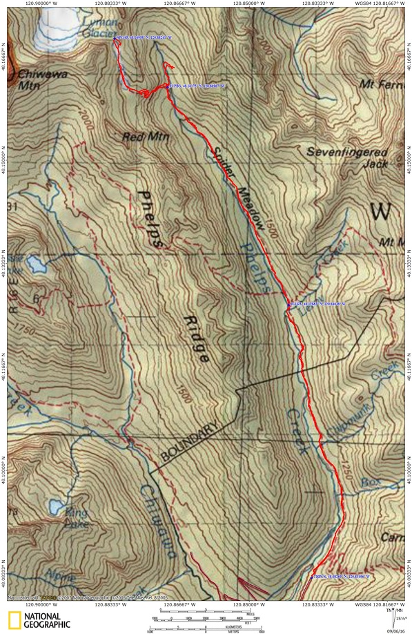
Trail Maps:
Topo Map, Download Garmin .gpx file
Review: October 24, 2015
This trail is also known as Spider Meadows Trail. Once you have arrived at the trailhead, turn around and enjoy the views of the nearby hills and the peaks to the south. The trail starts out on a wide path which was once a mining road. You soon walk over a small creek which is one of many small creeks you will cross, and in .25 mile you come to the Carne Mountain Trail junction. Keep left and stay on the wide trail which continues at a very moderate grade. In 2.5 miles you enter the Glacier Peak Wilderness and just after 3 miles you will pass some campsites.
Pay attention to this section of the trail so you can easily find the route on the return trip. Leroy Creek has washed out the trail and the re-route trail has a couple of faint spots. Just after Leroy Creek is a junction on the right for Trail 1512, Leroy Creek Trail, which goes to Ice Lakes. Drop back down to the main trail and continue for another couple of miles to Spider Meadow, at 5.4 miles from the trailhead. This glacial valley is filled with flowers in the spring and in the fall, a mix of brown and green. There are several campsites and a pit toilet at this end of the valley and a few at the head of the valley.
Walking through the open valley, admire the views of the mountains beside and ahead of you. It is a gentle ascent through the valley and the trail threads across Phelps Creek a few times at the head of the valley. Climb a little more steeply to the junction to Phelps Basin, 6.7 miles from the trailhead, and drop by for a visit. This pleasant little cirque has precious few campsites as the sides of the mountains slopes tail out near the creek.
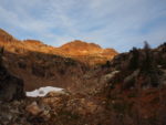
Return to the junction and head up the trail which soon becomes pretty steep as it climbs along the headwalls of the valley. Though it is less than a mile to what is left of Spider Glacier, it will take some time to ascend the tread which is filled with fist sized and larger rocks. At about 7.5 miles you reach the creek that flows from Spider Glacier and cascades down to Spider Meadow far below. There are some campsites here which must be wildly popular in the summer for their spectacular views. There also is a pit toilet here so you don’t have to try to dig a cathole in the rocky ground.
If the weather is reasonable and the snow is soft enough, you can walk up to Spider Gap. Be aware that when walking on the snow, there could be big voids below you from the stream or rocks that create melted voids around them. Watch your step so you don’t fall through the snow.
Hopefully you’ll be lucky enough to find a campsite on this little perch that is at elevation 6,200 feet.
There is a stream that flows from Spider Glacier over the precipice down into Spider Meadows and is a good place to filter water.
Retrace your way back through the meadows and forests to the trailhead.
Enjoy the photos!!
Gallery Pics
Switchback Steve