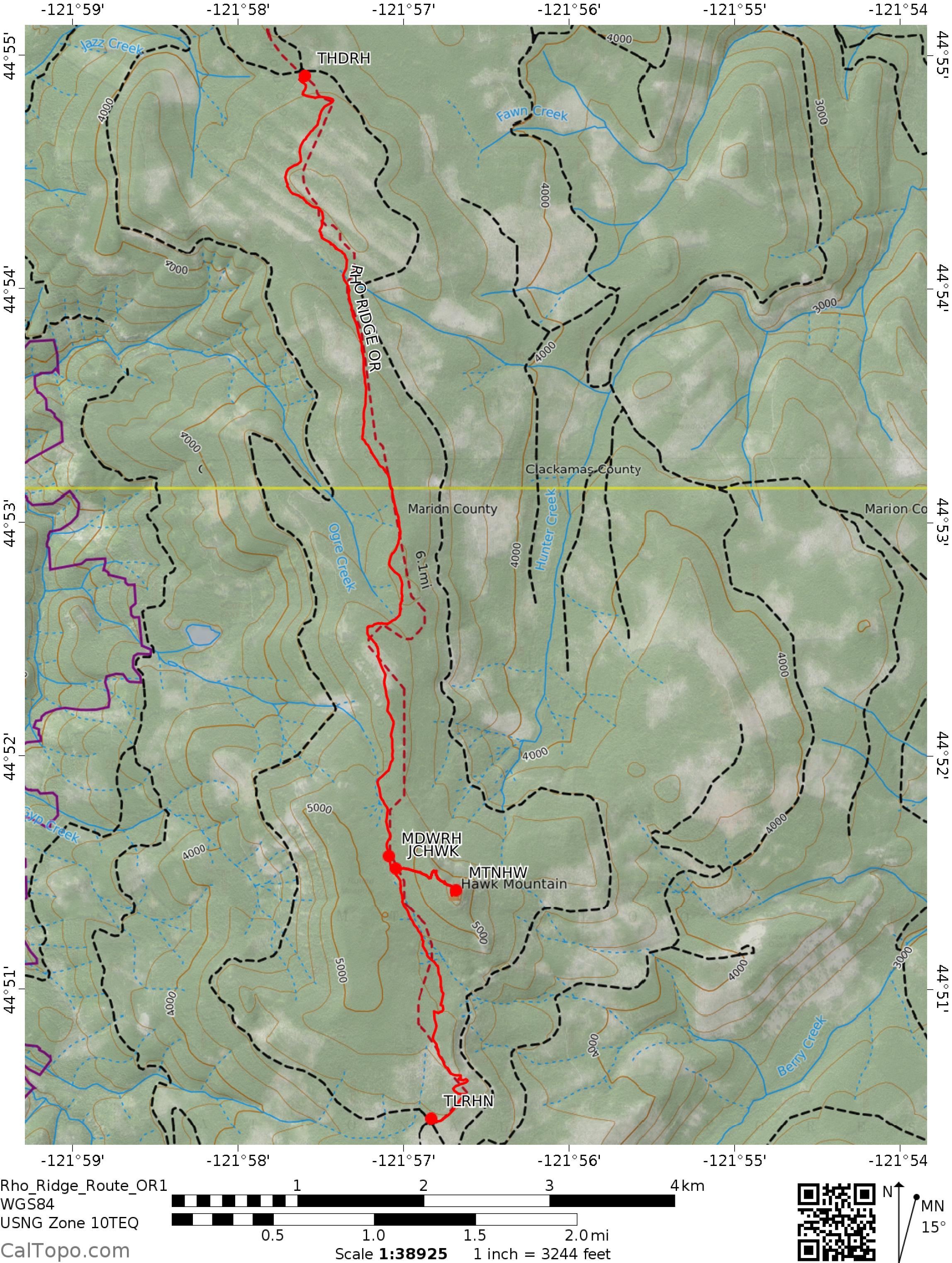
Rho Ridge Trail, OR
Notice: 8/15/2021 – FR46 is closed at both ends due to the Riverside fire in 2020. Currently the only way to this trailhead is by using FR42 to connect to FR46.
Vicinity Location:
The trailhead is about 57 miles southeast of Portland, Oregon in the Mt. Hood National Forest.
Directions:
From Portland via Estacada:
From Portland take I-84 east to I-205 south. Drive about 7 miles on I-205 S and take exit 13 for OR-224 W toward Milwaukie. Loop around and turn right onto OR-224.
Drive 2.1 miles and turn left onto HWY-212 E/OR-224. Continue for 1.6 miles and make a slight right to stay on OR-224 E for 40 miles, passing through Carver and Estacada. On the east side of Estacada, at the junction with Highway 211 for Molalla and Woodburn, keep straight on Highway 224 for the Upper Clackamas River and North Fork Lake.
You’ll pass the Ripplebrook Ranger Station and at the Ripplebrook Campground the road changes to FR 46.
Stay on FR 46 along the Clackamas River for 3.7 miles and turn right onto FR 63 at Riverford Campground and drive 15.4 miles.
Make a slight left to turn onto FR 6350 and drive for 6.7 miles. At the junction with FR 4670 look for a gravel parking area on the right.
For the southern trailhead continue another 7.6 miles on FR 6350 and look for the trailhead on your right.
No permits to park are required at either trailhead.
There are no bathrooms at either trailhead
Length and Elevation:
7.5 miles one way. Elevation at the trailhead is 4,324 ft. Highest Point on the trail is 5,249 ft. 1,724 ft elevation gain and 1,410 elevation loss.
Trails:
Rho Ridge Trail #564, Hawk Mountain Lookout Trail #564A
There is at least one geocache for this trail at: N 44° 51.400 W 121° 56.685 Info at Geocaching.com.
Trail Maps:
Topo Map, Download Garmin .gpx file
Review: 8/20/2017
This was done as a shuttle hike. Rhododendron Ridge separates the Collawash River and Clackamas River watersheds in the southern portion of Mt. Hood National Forest. The Skyline Trail used to run along the ridgeline.
Start out for about 100 feet on an old logging road then turn left into the forest. Follow a broad and gently sloping ridge following a seldom maintained trail. Travel through a nice second-growth forest with little meadows sprinkled along the way.
Some of the clearings provide views The farther you get from the trailhead, the more deadfall you encounter across the trail. There are places where small trees force you to push by their springy branches. The first few miles of trail are best avoided on a rainy day unless you want to feel like you’ve gone through a car wash.
After a few miles you break out into an old clear-cut. Cross another old jeep trail and head back into the forest. In about a mile is the junction for Hawk Mountain. Turn left and walk for about .75 mile on a well-maintained trail that goes through a forest of mountain hemlock, silver fir, and noble fir up to the summit.
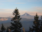
There is an old fire lookout on top of Hawk Mountain where you can stay in on a first-come basis but there is no nearby water in the summer. From the summit meadows there are great views of Olallie Butte, Mt. Jefferson and Jefferson Park. The meadow is rock strewn and dotted with juniper and spring wildflowers. Near the broad summit are some way trails that provide nice views of Mt. Hood. There is room for a couple of tents near the trees.
We backpacked here because it was in the path of the total eclipse of the sun August, 2017. There was a person who picked this spot using Google Earth and drove up from San Francisco.
Coming back down from the summit, you turn left at the junction for the Rho Ridge Trail and walk for about a mile through the forest, crossing a seasonal stream then climbing a bit before descending through several hillside meadows. A switchback or two gives nice views down the slopes and towards Mt. Jefferson and Jefferson Park.
Pass through some young trees and reach the south parking lot where you can finish the shuttle hike or retrace your steps to the northern trailhead.
This trail is safe for young children though there are sheer cliffs just off the trail near the Hawk Mountain Lookout. Starting at the southern trailhead and hiking north to the lookout at Hawk Mountain is a gradual ascent to the peak.
Enjoy the photos!!
Gallery Pics
Switchback Steve