Rogue River, OR
About 204 miles southwest of Portland, OR in the Rogue River-Siskiyou National Forest.
Directions:
From Portland, take I-5 south for about 230 miles, driving through Salem, Eugene, and Roseburg.Take exit 66 toward Hugo and drive 0.3 mile.
Turn right onto Monument Drive for 2.2 miles.
Turn right onto Pleasant Valley Rd and drive 2.6 miles.
Make a slight left onto Pear St and then turn right onto Galice Rd and drive 18.9 miles, crossing over the Grave Creek Bridge.
Turn left onto BLM Rd 34-8-1 and the road dead-ends at the Grave Creek Trailhead in about .25 mile. This is where the backpacking trip ends. If you use a shuttle service then you would probably park at another location. Parking here overnight is not advisable due to car prowls.
A free Wilderness Pass may be required thought I didn’t see a place at the Rogue River Ranch trailhead.
Outhouses available at Rogue River Ranch and at the Grave Creek Trailhead.
Length and Elevation:
25 miles one-way. Starting elevation is 500 feet and ending elevation is 690 feet. Total elevation gain is 4,698 feet and total loss is 4,508 feet.
Day 1 – Rogue River Ranch to Kelsey Creek – Started backpacking about noon and arrived in camp about 5:30pm.
Starting elevation 500 feet, ending elevation 550 feet. Gain of 1,300 feet, loss of 1,250 feet.
Distance travelled 8.45 miles.
Day 2 – Kelsey Creek to Tyee – Broke camp about 9:30am and arrived in camp about 5:30pm.
Starting elevation 550 feet, ending elevation 600 feet. Gain of 2,182 feet and loss of 2,132 feet.
Distance travelled 10.8 miles.
Day 3 – Tyee to Grave Creek Trailhead – Broke camp about 10am and arrived at 2:45pm.
Starting elevation 600 feet, ending elevation 690 feet. Gain of 1216 feet and loss of 1126 feet.
Distance travelled 5.75 miles.
Trail:
Rogue River Trail.
Trail Maps:
Topo Map – Overview, Download Garmin .gpx file
Rogue River Ranch: The area around Rogue River Ranch was once a major Native American site. Archeologists have found evidence that Native Americans have lived in the area for over 9,000 years. In the late 1800s, prospectors entered the area looking for gold in the gravel bars of the Rogue River.
In 1887, Tom Billings, filed an official homestead claim at the mouth of Mule Creek. One year later, Tom transferred the claim to his older brother, George. The growing settlement at Mule Creek was named after one of the early white settlers, Marial Billings.
By 1903, the Billings’ had finished building a 2-story main house and established a trading post and boarding house for travelers.
About 1907, the Red River Mining and Milling Company bought the land and structures around the mouth of Mule Creek. A two-story house and assay office were then built at Douglas Bar with up to 5 giant hydraulic nozzles washing the gravel at Douglas Bar.
In 1908, George and Sarah Ann built a barn, now known as the “tabernacle,” to stable horses and mules. In 1912, the Red River Mining Company was not profitable and it shut down. George Billings reacquired the original claim as an agricultural homestead and in 1916, George and Sarah Ann established a post office at the ranch.
The area was know as the Billings Trading Company until about 1930. It grew to become the center of social life about 100 residents of the Mule Creek/Marial area. People came from as far away as Bald Ridge and Paradise Bar to attend dances and church services. The boarding house attracted miners, travelers, and an occasional roguish character in need of a hideout.
In 1931, George Billings sold his 70-acre ranch to Stanley Anderson for $5,000. The Anderson’s later purchased 130 acres across the river from the ranch. In subsequent years, the Anderson family continued to improve the area and a blacksmith shop was added.
In 1970, the Anderson’s sold their entire holdings to the U.S. Government under the National Wild and Scenic Rivers program. At present, the Bureau of Land Management maintains this National Historic Site and keeps an on-site museum open for public viewing. The Billing’s original main house serves as a museum with displays on Native Americans, the mining and farming era of the late 1800s and early 1900s, and the Anderson era of the 1930s through 1970. The ranch is open from late May to October.
Whisky Creek: Around 1880, an unknown miner built the first cabin at Whisky Creek. The original cabin wasn’t much more than 4-walled shed with a cedar shake roof.
There is a small ditch near the back of the cabin. This was built about 1890 and begins 1/2 mile up Whisky Creek from the cabin. In 1905, the ditch was extended beyond the cabin to a point about 50 feet above Whisky Creek bar. This flume ditch provided drinking water for the cabin and water for hydraulic mining at both the cabin and bar.
In 1918 the claim was sold to Cy Whiteneck. Cy added a room and a floor to the cabin. He also built some of the sheds behind the cabin. Cy mined the in the area for 30 years and use hydraulic mining at Whisky Creek bar.
Mr. and Mrs. L.M. Nichols purchased the claim from Cy Whiteneck in 1948. The Nichols had conveniences added to improve livability of the cabin. A solar-heated shower and sawdust-insulated pantry were added.
Review: May 4, 2013
Jerimiah organized this trip and the weather cooperated by allowing the snow to melt off the roads that we needed to get to the Rogue River Ranch trailhead near Marial. Some sort of shuttle needs to be arranged for this hike. Parking overnight is not recommended at the Grave Creek Trailhead. Jerimiah contacted the Rogue Wilderness Adventures to charter a bus. He chose to have us dropped off at Rogue River Ranch, hike upstream, and to be picked up at Grave Creek Bridge for a total hike of 3 days. Hiking upstream would let us get home sooner than if we ended at Rogue River Ranch. Rogue Wilderness Adventures has a fenced parking lot which is locked at night so your car is safe from break-in.
We left Portland at various times of the day on Friday. Matt and I arranged to meet at one of the Beaverton MAX stations. It was easy to spot him in his bright orange running shoes. We were swallowed up with the mass of commuters and headed towards I-5. Traffic was lighter than I expected and soon we were south of Portland and heading towards Grants Pass.
After more than four hours of driving and stopping for a quick dinner, we pulled off I-5 and drove to Indian Mary Campground.
We joined most of our other backpackers, shared some beers and went to bed. Saturday morning we had a quick breakfast, used the facilities, and headed out… the wrong way.
After a couple of minutes, Jerimiah turned around and we all followed back to the shuttle service. We loaded our packs on to the roof rack and our driver took the 9 of us to I-5 and then headed north. After turning off I-5 and driving for a couple of hours, our driver stopped, looked at his hand-drown map, and said..”This isn’t right.”
Off we went down another road and after about 6 miles he found the right junction. You can’t help but think about being dropped off in the wilderness with no form of contact for help. The shuttle can take 3 hours to get to Rogue River Ranch and he didn’t know the ranch was still closed for the season. The driver dropped us off and we walked down to the ranch. Alone in the wilderness, totally dependent upon ourselves.
We ate and talked as we took turns exploring around the ranch. We found a plaque explaining the power is provided by a pelton wheel generator and solar panels. We wished we could go into the museum and look around a bit but all we could do is to peek in through the windows.
The weather was nice, about 70 degrees and sunny so we put on sunscreen and headed out. To find the trail from the main road, go through the gate to the ranch and the trail begins at the top of the first switchback and heads south. We walked along Mule Creek for a few minutes, then headed upstream along the Rogue.
Wildflowers are near their peak in early May with an abundance of blue and yellow iris. Blue alliums were in bloom along with Candyflower, Monkshood, and some yellow daisies along the trail.
The weather forecast for the trip was for sunny and hot and the day soon heated up. We walked at a moderate pace along the sun-dappled trail. The trail stays pretty high above the river, crossing multiple step-across streams. The bigger streams all had nice bridges over the streams. Look at the railings at the ends of the bridge for a sign with the name of the creek and trail mileage.
After about 4 miles, we were pretty well strung along the trail with Johnny and me in the front. The trail dropped down near the river and Johnny took the opportunity to take some clothes off and jump in. I soon followed into the cold, green water. Matt soon arrived and took a picture of us jumping off a 10 foot cliff into the river. Jerimiah jumped in too, but no one else.
We had a snack in a tree near the trail and headed out. The first 5 miles or so of the trail has an incredible amount of poison oak. There are even some places where poison ivy hangs into the trail. Be careful of unwittingly walking into poison oak in the trail space above the trail
We reached a junction to Zane Grey’s cabin. The group unintentionally split up to visit the cabin. Zane Grey bought the property on Winkle Bar in 1926 and from here fished and floated the river. He later wrote “Rogue River Feud,” helped to popularize the Rogue River. The cabin has been well preserved and has a plaque talking about the history of the cabin.
Eventually we caught up with Matt set up a protocol for keeping together on the trail. We walked a bit farther and found a nice big campsite at Kelsey Creek. The camp had room for all of us and the stream sounded very nice next to the camp. We set up camp and after dinner came up with the novel idea to hang bear bags from the bridge.
Brian brought some whisky and about ¾ of the bottle started a heated discussion on gun control and anarchy. I decided it was time to navigate past the poison ivy and go to bed.
Sunday morning we slowly got up over the course of about an hour and filtered water and made breakfast. We packed up at varying speeds and hit the trail about 9:30.
The trail rapidly climbed up to about 300 feet above the river. It felt cool in the shade but that didn’t last long. It seemed like there was less poison oak along this section of the trail but it was still a constant companion. At least once a branch of it arched over the trail just overhead.
We passed some great panoramas and shady glens where cool streams flowed down narrow valleys. The trail has a canopy of oak, California Laurel, and some other kind of broad leaved trees. In places the trail is covered with crinkley leaves. We crossed on a very nice wood and steel bridge over Meadow Creek. Meadow Creek is the last stop for dependable water. From here the trail really climbs and stays pretty high above the river.
We passed the junction for Horseshoe Bend but decided it was too early to stop for lunch and the river looked a long ways below the trail. We really noticed the heat as the trail climbed higher with the sun beating down on us. We were wishing for a few clouds as we passed a junction for Black Bar and pushed on.
We arrived at Bunker Creek and it looked like a great place to stop for lunch. Some sat in the shade by the stream and 3 of us went to look for a swimming hole. We found a deep eddy in the Rogue and jumped in. It felt great on a hot day. While we were going in and out of the water, I found a little scorpion in the rocks. I took some pictures of it and disposed of it because I didn’t want anyone to get stung.
Brian and Carissa came down to the river for a short swim and after we sat in the sun, we went back to rejoin the group. Carissa needed moleskin and I was glad to donate some. We sat by the cool stream for a bit then continued along the trail. There were more nice views of the river and patches of flowers scattered along the trail. There were some really nice views where a section of the trail had been cut into the cliffs. We were looking for campsites but couldn’t find any that were big enough for our group.
Eventually we reached Tyee. It is an unmarked trail dropping down to a wide sandbar along the Rogue River with grassy areas to camp on. We met a couple looking for a campsite and they decided to not share the area but to move on to the next campsite. We had seen a couple of puffy clouds early in the day but now larger clouds covered the sun and we heard distant thunder. By the time we got to the river and scoped out sites, we could see the rain in the distance. We only had a few minutes to set up our tents. Before I could pitch my tent the train started falling then quickly turned into a cloudburst.
I got into my tent and there was a big puddle of water at downhill side. After about 20 minutes of thunder and lightning the weather calmed and we came out of our tents or from under trees to see how wet we all were. A few of us had water in our tents but nothing worse than that. Some of us moved our tents nearer to the river. I was just starting to set up my tent when Brian started setting up next to me. I didn’t want to find out how loudly he snored so I moved my tent to the west end of the sandbar.
Once we finished setting up we got ready for dinner and Robert found a rattlesnake. It slithered into a hole and Robert plugged up the hole until the next morning. After discovering the snake, PJ quickly moved her tent down to the beach and out of the rocks.
Our third day on the river began with misty clouds left over from the thunderstorm. The early morning sunlight was beautiful as it lit up spots along the river. Some Canada Geese were eating grass along the river and one pair had some goslings. One bird kept watch with the other geese grazed.
A couple of us had put a stick at the shore to see how much the storm caused river to rise. The next morning we saw the river had risen less than .25 inch. We weren’t in any hurry because we had scheduled the shuttle to pick us up at 3pm and we had less than 6 miles to travel.
Johnny and I were to only to for going in the river the last morning. I went swimming for a bit and Johnny washed up. The best way to get in to the water is to jump in. Just dipping a toe in doesn’t seem to work for me. I had time to wander around admiring the views of the river and the Madrone or Myrtlewood trees. There were some seeps that came out at the river and they made nice little ponds along the river shore. The clouds were slowly burned off by the sun and we could tell it was going to be another hot day.
The climb back to the trail was steep but short. Once again the trail climbed fairly high above the river. We walked past many patches of iris and other flowers blooming along the trail. After about 1.5 mile we reached the junction for the cabin at Whiskey Creek. Some of us stayed at the junction and Jerimiah and I walked less than .2 mile up to the cabin. Whisky Creek Cabin is one of the few remaining relics of the Rogue River Gold Rush era. There are some rusted metal gears in the yard and the cabin is in good shape. The inside walls are without insulation and you can imagine how hard it must have been to heat in the winter and how cold the cabin must have been every morning.
The trail crosses Whisky Creek on a nice bridge and goes by a lovely green pool. Johnny said he couldn’t resist taking a dip in the stream. We met a few people on a day hike and saw a few people rafting down the river.
The trail climbs up above the river and the tree cover is pretty sparse. The trail gets a little rockier as the canyon narrows. The trail drops and climbs throughout the route. About lunchtime Johnny and I took the junction down to Rainie Falls. The best way to get a view of Rainie Falls is to bushwhack a trail as close to the river as possible. Poison oak grows close to the river here. There were also some wild grape vines growing in the trees on the way to the falls. We went to the falls but there isn’t much to see from the northern shore. We decided this was not the best lunch spot and went upstream about a tenth of a mile from the falls. There was a nice pool of water in the river and Jerimiah, Johnny, and I went for a cool swim.
After lunch we climbed back up above the river on the trail and struggled a bit through the heat of the day. Looking back, there was a nice view of Rainie Falls, though all you can really see are some huge rapids in the distance. There is no water between Rainie Falls and the trailhead. A couple of us ran out of water before the end of the trail and were getting a little dehydrated in the heat. This last section of the trail is really the only part of the trail that is constantly along the edge of cliffs. Sections of the trail are a little narrow and falling off the trail along this section would probably result in a 100 tumble down the rocks and into the river.
We passed a sign that showed the high water mark from the 1964 flood. The river rose 55 feet above its normal level and covered many sections of the trail. The devastation of the trees along the river from the power of that flood must have been amazing. Perhaps that is why so much of the trail is quite a ways above the river, to keep it out of the way of catastrophic floods.
Jerimiah, Matt, and I waited on a promontory with a view of the trailhead. We didn’t see a reason to hurry to the hot parking lot at the end of the trail. We were also waiting to make sure Carissa and Brian were coming along the trail okay. Carissa and Brian showed up after a bit and we walked the rest of the way to the trailhead. Some of the earlier people who arrived had gone for a swim.
We took some celebratory photos at the trail sign and I shared my water with the thirsty backpackers and the shuttle van was early and arrived within 5 minutes of our getting to the end of the trail.
It didn’t take long to get our gear loaded into the van and for our trip to be over. For years I had wanted to take this trip and I think taking the trip early in the season is the best choice.
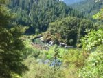
The Rogue River begins at a spring near Crater Lake and ends 215 miles later at Gold Beach on the Pacific Ocean. The river cuts through the Klamath-Siskiyou Mountains and is one of the most beautiful rivers in the nation.
This trip is not appropriate for dogs or children because of the length of the trail, the geology of the trail, and the environment. You cannot but help to come in contact with Poison oak, the only questions are how much and how sensitive you are to it. I was the only person who had a tick embedded in me but someone else broke out with Poison oak. There is no problems with any of the stream crossings. All the major creeks have nice bridges over them. All the other streams are easily crossed, unless you slip on the rocks.
Thanks to Jerimiah for organizing this trip great trip along the Rogue River.
Enjoy the photos!!
Gallery Pics
Switchback Steve