Saddle Mountain, OR
Notice: 2/6/2026 – Saddle Mountain State Natural Area in Oregon is closed from December 29, 2025, through April 1, 2026
Directions:
From Portland, take Highway 26 west about 63 miles to Saddle Mountain State park. Turn right and follow the narrow, paved park road 7 miles to the trailhead parking area. Take extra caution from around mile 4 to the parking area. There are two downhill stretches of road that have dips that WILL bottom out your car if you are going over 5 MPH. Pay particular attention to gouges in the pavement. You will have to hit the brakes HARD to avoid scraping your car. How hard did those vehicles bottom-out to make the gouges?
No permits are required for day-use parking.
Flush toilets and water available at the trailhead. The campground and trail access are gated off and closed during the winter. Campground and trail conditions are available by calling the Oregon State Parks Information Center M-F 8am-5pm (1-800-551-6949)
Length and Elevation:
5 Miles total, Elevation at the trailhead is 1,650 feet. Total elevation gain 1,700 feet. High point on the trail is 3,283 feet.
Trail:
Saddle Mountain Trail
There is at least one geocache along this trail at: N 45° 58.090 W 123° 41.156 Info at Geocaching.com
Trail Maps:
Topo Map, Download Garmin .gpx file
Review: July 20, 2008, May 24, 2009
The trail climbs gently and passes through the campground. The path is lined with Salmonberry bushes and passes through a forest of alder and fir trees. In about .25 mile is the junction for Humbug Mountain trail off to the right, which goes for about 1,000 feet to a nice view of Saddle Mountain. At the bend in the Humbug Mountain trail, look for a rock on the left that looks like a bear’s head in profile. Walk past the moss-covered boulders and climb the rough-cut stairs to the viewpoint of Humbug Mountain and enjoy the vista.
Back on the trail, the tread begins to ascend steeper and begins a series of switchbacks. There are some nice views across a valley of alder and fir trees. The trail climbs through sections of blowdowns that trail crews have cut through and reconstructed the trail. After about 1 mile is a viewpoint with a small pinnacle topped with an egg shaped rock.
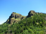
After going about 1.5 miles there is an open area with great views to the southwest and up to Saddle Mountain. Look up and see if you can see the rock formation that looks like the man in the mountain. The two boulders near the top on the left are his eyes and below, on the profile of the mountain is his nose, lips, and chin.
Trail reconstruction to repair washouts and other storm damage for 2008 was completed in mid-August. This has made the trail wide and well maintained for the first mile, and then it narrows as you approach the saddle. The trail drops down and goes across the saddle, then climbs a steep track with loose gravel. Make your way to the top and look north across the Columbia, northwest to Astoria, beaches, and the Pacific Ocean, and south to the forests of Oregon.
On a clear day, you may be able to see snow on the Olympic Mountains, Mt. Rainier, Mt. St. Helens, and Mt. Adams, just to the right of Mt. St. Helens.
The open meadows have some of the nicest flower displays in northern Oregon in June and July.
When you’re ready to go back, pick your way back down, across the saddle, and back up to the viewpoint where you can look back and see people at the top.
Thread your way past the people coming up the trail and return to the trailhead.
This trail is not the best choice for small children or inexperienced hikers due to the loose gravel in the trail and drop-offs along the trail.
Enjoy the photos!!
Gallery Pics
Switchback Steve