Salmon Creek Trail, WA
Directions:
East Trailhead:
From I-5, take exit 5 for 99th St. Drive and turn left at the traffic light to drive west on 99th street for about .25 mile. Turn right onto NE Hazel Dell Avenue. In about .9 mile, bear right at the traffic light to stay on Hazel Dell Avenue/NE 117th St.
There are two areas to park at the east end. You can look for the Salmon Creek Sports Complex, which is in about .2 mile farther, and turn left into the parking lot or continue 0.4 mile further to Klineline Pond and turn left into the parking lot.
There is a fee at Klineline Pond to park. You can get an annual Clark County Parks pass for $30 or the daily parking fees are:
$2 for motorcycles.
$3 for cars and trucks.
$6 for cars and trucks with trailers.
$8 for buses or motorhomes.
Length and Elevation:
6 Miles round trip Elevation gain 100 feet and loss of 100 feet. Total gain and loss is 200 feet. Elevation at the east trailhead is 100 feet.
Trail:
Salmon Creek Trail.
Flush toilets are available in the summer months at Klineline Pond, the Salmon Creek Sports Complex, and there is a portable toilet at the west trailhead.
No permits are required to park at the west trailhead but there is limited parking and it gets crowded.
Park rules prohibit littering, vandalism, alcohol possession, discharge of firearms, ATV, ORV, disorderly conduct, unleashed animals, camping, or fires
Park hours are 7am until dusk.
Trail Maps:
Topo Map
Review: September 22, 2008, May 24, 2020
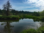
This is a very pleasant walk, run, or bike ride along a Salmon Creek on a paved trail. There are usually Great Blue Herons along the creek and ponds and turtles in the ponds anytime the weather is sunny and warm.
Starting at the Sports Complex, you can head east for .25 mile, cross the bridge into the park, turn right, and pass underneath the freeway to a large pond. Heading east from the complex, you skirt the softball fields on the northern side, then pass by a pond with a bench and along Salmon Creek. You can frequently see turtles sunning themselves on logs in the pond.
If you want to use the mile markers on the trail, the .25 mile mark is at the east end of the sports complex. The trail starts at Klineline Pond.
JC2 is .25 mile feeder trail that goes through meadows and several habitat restoration areas. It is surprisingly wild. Trees hide most of the houses and apartments that are on top of the ridges above the valley.
At TH1 there is parking along the road. Follow a gravel road west then drop down to an access trail. Head north to the main trail or walk east or west from the bottom of the hill and parallel the main trail.
If you want to make more of a loop, make a right at JC2 and follow the dirt trail which follows the southern edge of a large meadow, past a couple of houses. Where the trail reaches a paved trail, make a left, walk about 150 feet, and turn right, back onto the Salmon Creek Trail, heading back towards the parking lot.
There are some user trail junction that are just small feeder trails and not meant for general access.
There is a nice trailhead at waypoint S2. There is plenty of parking along the road and the trail runs along a small tributary to Salmon Creek. The trail begins at a white metal gate and from the gate, the trail drops down into a shady forest. This is one of the nicest parts of the trail because it is in the shade and follows near the small creek.
Just above JC11, out of sight of the main trail, is a picnic trail where you can sit in the shade and listen to the small creek nearby. Shortly after JC11, the trail goes along Salmon Creek through a large meadow. SCT9 is the junction at NW Seward Rd and NW 36th Avenue, with parking along the road.
On the way back to the parking lot, when you see the softball fields, remember to turn left and walk on the north side of them and not go straight ahead.
Enjoy the photos.
Switchback Steve