Sawtooth Mountain, WA
Vicinity Location:
The trailhead is about 58 miles northeast of Portland, Oregon in the Gifford Pinchot National Forest.
Directions:
From Portland, Oregon, there are two ways to drive to the trailhead. If you have an extra 30 minutes then make your trip a loop drive.
For the loop drive, take I-205 north across the Columbia River. Exit I-205 on HWY 14 east for about 28 miles through the town of Stevenson.
For the non-loop option, take I-84 east from Portland and take exit #44 for Cascade Locks. Take the first right turn just after you go under the Bridge of the Gods. Pay the $3.00 toll, cross the bridge, and turn right onto Highway 14 then drive 2.5 miles to Stevenson.
For the non-loop option take I-84 for the outbound and return drives.
Once you get to Stevenson, drive about 2 more miles east to Wind River Road. Wind River Road is 5.9 miles east of the Bridge of the Gods. Drive on the Wind River Road for 13.4 miles until about 0.25 mile past the Carson National Fish Hatchery.
Turn right onto FR30 and follow this road for 13.2 miles north along the Wind River and then up the winding road, pass a couple of sno-parks, to the junction of the Curly Creek Road.
Continue north on FR30 for another 10.6 miles and turn right onto FR24 and follow it for about a mile. Look for the Pacific Crest Trail crossing the road and the trailhead is on the right side of the road. Park along the road.
No permits are required to park along the road.
There are no bathrooms.
Length and Elevation:
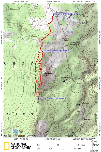
5.7 miles roundtrip. Elevation at the trailhead is 4,270 ft. Highest Point on the trail is 5,192 ft. There is 927 ft elevation gain and 927 feet loss in elevation roundtrip.
Trails:
Pacific Crest Trail #2000, Sawtooth Mountain Trail #107.
There are no geocaches along this trail.
Trail Maps:
Topo Map, Download Garmin .gpx file, Open Garmin .gpx file
Review: September 3, 2020
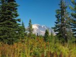
From the trailhead you walk through a brushy meadow studded with noble fir and pine trees. Look around for views of Mt. Adams through the trees. There are huckleberries in patches along a large part of this trail and is a traditional berry picking area. As you head south the terrain changes, the forest closes in, and the trail genly climbs beneath mountain hemlock and silver firs. The undergrowth contains many huckleberry bushes and avalanche lilies.
The trail levels and go along sections that are dusty from the ground up pumice and section where the trail is covered in fir needles. The trail dips through a small meadow then continues gradually up past the wilderness sign for Indian Heaven Wilderness at mile 1.25.
After about 1.5 miles you reach the junction for the Sawtooth Mountain Trail where you continue straight on trail #107 and the PCT goes off to the right. This seems a little odd but old maps show the Pacific Crest National Scenic Trail using the route of what is now the Sawtooth Mountain Trail. The PCT was relocated downslope in the 1970’s and this loop trail option came into being.
Soon you’re climbing a steepening trail through the forest of mostly noble fir. You can tell the trail isn’t used as much because it is all covered with a layer of fir needles which makes for a quiet walk in the forest. After a couple of switchbacks you come out to a rocky viewpoint looking out at Mt. Adams. You can see a knob of a mountain off to the right of Mt. Adams which is Sleeping Beauty.
Continue through the forest of old growth trees and soon you are going up a ridgeline towards the top. The trail does not go to the top of Sawtooth Mountain. It looks like a dangerous scramble to the summit but there are a couple of promontories where you can get a nice view of Mt. St. Helens and Mt. Rainier. To the south you can see Bird Mountain and Lemei Rock.
The trail traverses the upper slope of the mountain, drops down through the forest a bit, then comes out to a large red cinder slope that the trail switchbacks down into a brushy trail then back into the forest.
After dropping down through the forest you reach the PCT again. There is sort of a 4-way junction here. Turn right because going straight just leads to a couple of dry campsites.
Head gently uphill through the forest a bit before descending through the lovely forest. Coming back is a pleasant walk mostly downhill back to the trailhead.
The trail goes along tall cliffs around Sawtooth Mountain so this trip isn’t recommended for small children or dogs.
Enjoy the photos!!
Gallery Pics
Switchback Steve