Silver Shadow Trail, WA
Vicinity Location: The trailhead is about 26 miles northeast of Portland, Oregon in the Yacolt Burn State Forest.
Directions: From Portland drive North on I-5 from Vancouver and take exit 11 then turn right and take highway 502 5.8 miles to Battle Ground. You can also take I-205 to exit 30B and then highway 503 from north to Battle Ground.
From the main intersection at Battle Ground (Highway 502 and 503 near the Fred Meyer store)
Drive North on highway 503 for 5.6 miles and turn right onto Rock Creek Road. There should be a sign saying “Lucia Falls, Moulton Falls”.
Drive east for 8.6 miles as Rock Creek Road becomes Lucia Falls Road.
Turn right on Sunset Falls Road. There’s a sign saying “Sunset C. G.” and drive for 2 miles.
Turn right on Dole Valley Rd, cross over the East Fork Lewis River on a narrow bridge, and follow the paved road generally uphill 2.4 miles.
At 18.6 miles from Battle Ground, turn left onto gravel road L1100 and drive 2.2 miles on a gravel road to a wide intersection. Turn right and proceed about 300 feet to the Tarbell trailhead. There is parking for about a dozen cars but this trail is not heavily used.
Discover pass required at the Tarbell trailhead for parking.
Bathroom available at the Tarbell trailhead
Length and Elevation:
Total trip is 5.1 miles. Elevation at the trailhead is 1,854 feet. Total ascent is 1,068 feet and total descent is 1,068 feet. Highest point is at 2,210 feet. Lowest point is 1,496 feet.
Silver Shadow trail only: Distance is 1.8 miles. Elevation at the upper junction is 2,210 feet. Elevation at the lower junction is 1,550 feet.Total ascent is 5 feet and total descent is 667 feet. Highest point is at 2,210 feet. Lowest point is 1,550 feet.
Trail:
Tarbell Trail (Part of the Chinook Trail), Silver Shadow Trail
There are no geocaches along this trail.
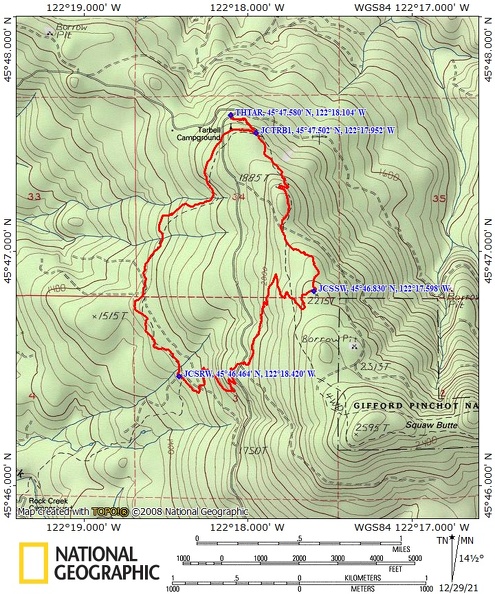
Trail Maps:
Topo Map, Download Garmin .gpx file, Open Garmin .gpx file
Review: November 12, 2020
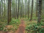
This trail is accessed most easily from the Tarbell Trail. Walk up from the trailhead for about 0.25 to a 3-way junction to the actual Tarbell trail and turn left. In springtime hundreds of wild iris bloom along this first 0.25 mile of trail. The trail climbs moderately first through a young second growth forest, then along the edge of an older forest which is an island in a sea of young trees. Climb up through a couple of switchbacks through the forest.
As you climb the undergrowth changes to sword ferns, Oregon grape, and salal with a few huckleberry bushes and vine maples. The trail is somewhat rocky but pretty easy to walk on. This trail is popular with mountain bikers and gets some use from horses so keep an ear out for these people approaching.
In about 0.75 the trail crosses a gravel road and enters a large clear-cut which provides nice views of the surrounding hills but in itself is pretty ugly. The trail passes through a section of second growth forest and comes out into a clearcut and after about 100 feet is the junction for the Silver Shadow Trail. Turn right here and walk out into the clear-cut. There are nice views of the surrounding mountains which will disappear once the newly planted trees grow to obscure the views.
Descend through several switchbacks in the clear-cut then continue switchbacking down through a second growth forest. This section appears to be a little wetter because there is a lot of apple clover and trailing blackberries growing. The forest sighs pleasantly on breezy days as you wend your way downhill back towards the Tarbell trail.
Cross a small stream and continue on a section of level trail through the forest. After about 2.25 miles you come to a gravel road. Walk down to where it joins a second gravel road then walk to the left about 75 feet and look for the continuation of the trail descending off the road.
In 2.8 miles you reach another gravel road where you go straight across the road and continue down the Silver Shadow trail, descending down switchbacks. At 3 miles you reach the end of the Silver Shadow trail and rejoin the Tarbell trail. Make a right and cross directly over another gravel road then back into the forest.
Soon you’ll cross another stream on a bridge then head uphill through the forest and out into another clear-cut. At 3.25 miles go straight across another gravel road and head generally north through another clear-cut. At 3.6 miles you come to another gravel road where you turn left and walk about 200 feet down the gravel road then turn right to remain on the Tarbell trail.
At about 4 miles you come to a sturdy bridge crossing a small creek. Past the bridge you walk along the edge of a young second growth forest and gently ascend towards the Tarbell trailhead. At 4.5 miles the trail comes out into a very large clear-cut area and climbs up to another gravel road. Cross this road and it is just a short distance to the junction where you turn left to return back to the Tarbell trailhead.
Enjoy the photos!!
Gallery Pics
Switchback Steve