Siouxon Creek, WA
Notice: 7/5/2023 – This trail is once again closed due to a previous forest fire.
Notice: 8/14/2021 – Because of the Big Hollow fire the traditional trailhead is closed. The trailhead is now 2 miles west and adds 4 miles to this hike. Much of this trail is in a burned area and should not be hiked in times of heavy rain or high wind. Watch for hazard trees falling unexpectedly.
Vicinity Location: The trailhead is about 38 miles northeast of Portland, Oregon in the Gifford Pinchot National Forest.
Directions:
From Battle Ground, WA, take Hwy 503 North to Chelatchie Prairie. Turn East (right) at the Chelatchie Prairie General Store and gas station, onto NE Healy road. The store is on the northeast corner of Hwy 503 and NE Healy road. NE Healy road changes into Forest Road 54 after a few miles. Follow this route for about 9 miles from the general store.
Look for the “pavement ends sign” and turn left, uphill, on FR 57 After another mile turn left again onto Rd. 5701. This junction is just past a quarry on the left. Follow this mostly paved road to the trailhead in a little more than 4.9 miles from the junction with FR 57. Even though the high point on the road is less than 2,000 feet in elevation, late winter snow can block this road. This is because after it crosses a ridge and the road is in the shade as it drops down to the trailhead.
Call the Gifford Pinchot National Forest for current information at (360) 891-5000 or visit the Gifford Pinchot Recreation webpage for the road and snopark information.
There are no restrooms at the trailhead. The nearest bathrooms are at the Mt. St. Helens Monument Headquarters in Chelatchie Prairie (Amboy).
No permits are required to park at the trailhead.
Trail:
GPNF Trail 130 with connections to 130A, 140, and 156
There is a geocache along trail 130 at: N 45° 56.908 W 122° 10.458 Info at Geocaching.com
Trail Maps:
Topo Map, Download Garmin .gpx file
Length and Elevation:
11.4 Miles Roundtrip, Elevation gain is 2,000 feet and elevation and loss totals 2,000 Feet. Highest elevation is 2,386 feet and lowest elevation is 1,223 feet.
Review: February 27, 2005, May 19, 2007, October 22, 2008.
This is perhaps my favorite trail to hike on a cloudy day. The first four miles of the trail are covered with a second-growth canopy with a couple of old-growth trees in the upper portion of the trail.
One time we started from the end of the road, which is not the correct starting point, and descended steeply down to the trail. The trail starts from the beginning of the parking area by the signs. On this hike I found the actual trailhead sign. It is about 100’ back up the road from the parking lot, then down a small footpath.
Once you’re on the trail, you’ll want to go to the right, upstream. This is such a nice trail through the trees and along the creek. The water in the pools along the creek have such a nice shade of green and are incredibly cold. I’ve gone swimming in the summer and I could only stay in for a few minutes at a time. This trail is popular with mountain bikers and hikers on the weekends.
The first bridge is .1 miles downhill with a campsite on the other side. My advice is to skip this camp because it is so close to the trailhead. In about a mile you’ll come to the Horseshoe Ridge trail junction. This is a steep uphill trail that later descends back to the Siouxon Creek trail. Continue along the creek about .4 miles to the next bridge which is above Horseshoe Creek Falls. Go just about another .2 mile and look for a trail junction on the left, which goes downhill to some nice campsites. If these are full then go on up the trail and take a rest on the bench overlooking the falls on Siouxon Creek. You’ll find other places to make camp along the way as you continue up the trail.
After about 4 miles from the trailhead you’ll come to a junction in the trail. Have a seat near or under the bridge and marvel at the clear, green water gently flowing by. You can also be thankful that the Forest Service never completed the road along this stretch of Siouxon Creek.
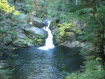
Cross the bridge over the creek and see Chinook Falls about .25 mile further up the trail, or continue on the South side of the creek into the upper Siouxon Creek area. You’ll want to see the plunge-pool waterfall on Chinook Creek. On the way to the waterfall you’ll pass another series of campsites.
Most people turn around here but if you want to go further, cross Chinook Creek and look for the trail going back downstream on the opposite bank. In 2008, the easiest place to cross is just downstream where a narrow tree has fallen clear across the creek. You can rock-hop to the log, then use the log as a handrail to hop from rock to rock across the creek. Mountain bikers may choose to pedal across at the gravelly fording area just upstream from the log. Once across the creek, you’ll have to look a bit to find the trail. Deadfall partially obscures the trail on the north side of the creek. You’ll reach another junction in about .5 miles. You can continue uphill to Forest Road 6403 or you can continue towards Wildcat Falls or make a long loop past Huffman Peak then back down to Siouxon Creek. Note the U.S.G.S maps for part of the trail appear to be out of date.
A group of us searched for the geocache listed above for over an hour and couldn’t find it in May of 2007. Best of luck finding it.
Pictures of this hike
Switchback Steve