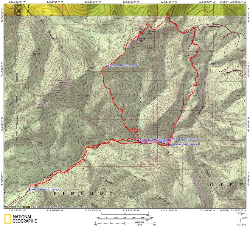
Siouxon Peak, WA
Notice: 7/5/2023 – This trail is once again closed due to a previous forest fire.
Notice: 8/14/2021 – Because of the Big Hollow fire the traditional trailhead is closed. The Siouxon Creek trailhead is now 2 miles west and adds 4 miles to this hike. Much of this trail is in a burned area and should not be hiked in times of heavy rain or high wind. Watch for hazard trees falling unexpectedly.
Vicinity Location: The trailhead is about 38 miles northeast of Portland, Oregon in the Gifford Pinchot National Forest.
Directions:
From Battle Ground, WA, take Hwy 503 North to Chelatchie Prairie. Turn East (right) at the Chelatchie Prairie General Store and gas station, onto NE Healy Road. The store is on the northeast corner of Hwy 503 and NE Healy Road. NE Healy road changes into Forest Road 54 after a few miles. Follow this route for about 9 miles from the general store. Look for the “pavement ends sign” and turn left, uphill, on FR 57 After another mile turn left again onto Rd. 5701. This junction is just past a quarry on the left. Follow this mostly paved road to the trailhead in a little more than 4.9 miles from the junction with FR 57. Even though the high point on the road is less than 2,000 feet in elevation, late winter snow can block this road. This is because after it crosses a ridge, the road is in the shade as it drops down to the trailhead.
Call the Gifford Pinchot National Forest for current information at (360) 891-5000 or visit the Gifford Pinchot Recreation webpage for the road and trail information.
There are no restrooms at the trailhead. The nearest bathrooms are at the Mt. St. Helens Monument Headquarters in Chelatchie Prairie (Amboy).
No permits are required to park at the trailhead.
Trail:
GPNF Trail 130 with connections to 130A, 140, and 156
There is a geocache along trail 130 at: N 45° 56.908 W 122° 10.458 Info at Geocaching.com
Trail Maps:
Topo Map, Download Garmin .gpx file
Length and Elevation:
18.5 miles roundtrip. Elevation at the trailhead is 3,790 feet. Total gain is 4,700 feet and loss is 4,700 feet. Highest elevation is 4,169 feet and the lowest elevation is 3,601 feet.
Review: August 9, 2015
The first four miles of the trail are covered with a second-growth canopy with a couple of old-growth trees in the upper portion of the trail.
One time we started from the end of the road, which is not the correct starting point, and descended steeply down to the trail. The trail starts from the beginning of the parking area by the signs. On this hike I found the actual trailhead sign. It is about 100’ back up the road from the parking lot, then down a small footpath.
Once you’re on the trail, you’ll want to go to the right, upstream. This is such a nice trail through the trees and along the creek. The water in the pools along the creek have such a beautiful shade of green and are incredibly cold. I’ve gone swimming in the summer and I could only stay in for a few moments at a time. This trail is popular with mountain bikers and hikers on the weekends.
The first bridge is .1 miles downhill with a campsite on the other side. My advice is to skip this camp because it is so close to the trailhead. In about a mile you’ll come to the Horseshoe Ridge trail junction. This is a steep uphill trail that later descends back to the Siouxon Creek trail. Continue along the creek about .4 miles to the next bridge which is above Horseshoe Creek Falls. Go just about another .2 mile and look for a trail junction on the left, which goes downhill to some nice campsites. If these are full then go on up the trail and take a rest on the bench overlooking the falls on Siouxon Creek. You’ll find other places to make camp along the way as you continue up the trail.
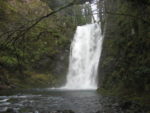
After about 4 miles from the trailhead you’ll come to a junction in the trail. Have a seat near or under the bridge and marvel at the clear, green water gently flowing by. You can also be thankful that the Forest Service never completed the road along this stretch of Siouxon Creek. Cross the bridge over the creek and about .25 mile further up the trail is Chinook Falls. On the way to the waterfall you’ll pass another series of campsites.
Cross Chinook Creek and look for the trail going back downstream on the opposite bank. The easiest place to cross is just downstream where a narrow tree has fallen clear across the creek. You can rock-hop to the log, then use the log as a handrail to hop from rock to rock across the creek. Mountain bikers may choose to pedal across at the gravelly fording area just upstream from the log. Once across the creek, you’ll have to look a bit to find the trail. Deadfall partially obscures the trail on the north side of the creek.
Continue up the trail and turn right at the signed junction and climb up the Chinook Creek drainage. At 7.1 miles, join FR 6403 and bear left. From here for views of Mt. St. Helens, Rainier, and Mt. Adams.
As you climb higher there are wonderful views of Mt. St. Helens and Swift Reservoir. One more bit of climbing brings you to the finned-back summit of Siouxon Peak at 8.1 miles. Take the narrow, brushy side trail to the 4,170-foot summit.
There are more great views of Swift Reservoir, Mt. Rainier and Mt. Adams. Drop back down to the main trail and turn left. Head down 2,000 feet in 2.5 miles through the trees past views of Wildcat Falls, then drop down and pass the front of the 225 foot high Wildcat Falls at 11.9 miles.
The trail follows Wildcat creek for a couple hundred feet to a trail junction. The right leads down to a ford of Siouxon Creek and Wildcat Trail #156 continues on the left. After about 200 feet on the main trail, you come to Wildcat Creek. You will want to go downstream a bit and cross on the rocks in the creek. The logs here are slippery and using them to cross is dangerous. After that, the trail follows along Siouxon Creek and climbs above the creek on the way to Chinook Falls. This upper part of Siouxon Creek is a rainforest with sphagnum moss hanging off all the Vine Maples and fallen logs. You can see this area is very wet through much of the year.
After about .5 mile you reach a junction for trail 130A and you turn right and head towards Chinook Falls. Chinook Falls is about 50 feet high and you can walk almost to the base of the falls.
The best crossing for Chinook Creek is slightly downstream of Chinook Falls. There is a log across the creek that is used as a handrail while rock-hopping across the creek. Using this method, you avoid walking on top of a log and the chance of falling onto the rocks in the creek.
From there, the trail goes along Chinook Creek past a couple of camping areas and crosses Siouxon Creek on a log bridge. The trail generally follows Siouxon Creek back to the trailhead. There are beautiful green pools and some waterfalls to enjoy on your way back to the trailhead. The trail here is very well maintained and popular with mountain bikers so be prepared to give way to them on weekends.
The trail is wide, fairly level without too many ups and downs but descends gently towards the trailhead. It is a very pleasant walk listening to the sounds of the creek as you make your way back to your car.
About 1.5 miles after crossing Chinook Creek is a 30 foot waterfall on Siouxon Creek with a bench nearby where you can sit and enjoy the sights and sounds of the waterfall. In about 1000 feet farther down the trail is a junction for a side trail that is about .3 mile long. This side trail leads down past campsites to a viewpoint of a waterfall on a small stream.
About .2 mile after the junction for the side trail, Siouxon Creek Trail #130 crosses Horseshoe Creek just above the waterfall on a metal girder bridge with a wood deck. The trail continues through the woods for about a mile to another bridge. This bridge crosses West Creek about 10 feet above the creek.
The last part of this trail is about a 100 foot climb back up to the parking lot.
Enjoy the photos!!
Gallery Pics
Switchback Steve