Skyline Trail, WA
Vicinity Location:
About 14 miles east of Ashford, WA in Mt. Rainier National Park.
Directions:
From Seattle, take I-5 South to Hwy 512 East and go towards Puyallup (Exit 127). Follow Hwy 512 East for about 2 miles. Turn south onto Hwy 7 towards Mt. Rainier. Follow Hwy 7 south to Elbe. At Elbe, turn left onto Hwy 706, travel through Ashford, and then to the Nisqually entrance of Mt. Rainier National Park. Now, follow the last paragraph of the directions.
From Portland, take I-5 North and take exit 68 to Hwy 12. Take Hwy 12 for about 30 miles to Morton. Turn left into Morton on Hwy 7 and drive about 17 miles to Hwy 706. Turn right on Hwy 706 and drive to the Nisqually entrance on the west side of Mt. Rainier National Park. The drive take about 3 1/4 hours.
Go early on peak weekends. Once you are in the park, continue about 18 miles on the Longmire-Paradise Road. If you are in the park by 9 am then you can follow the signs and probably park at the Paradise Inn parking lot.
National Park entrance fee must be paid to enter Mt. Rainier National Park.
Flush toilets available at the parking lot, near Paradise Inn and at Jackson Memorial Visitor Center
Length and Elevation:
6.7 miles round trip using High Skyline Trail, 5.2 miles – Skyline Trail. Elevation gain 1,715 Feet and loss of 100 feet to the junction for Upper Skyline Trail and McClure Rock Trail. Total gain is 2,200 feet and and elevation loss is 2,200 feet round trip. Elevation at the trailhead at 5,430 feet, highest point is at 7,359 feet. Lowest elevation is 5,430 feet.
Trail:
Skyline Trail, Alta Vista Trail, Glacier Vista Trail, and Upper Skyline Trail with connections to Pebble Creek Trail and multiple other trails.
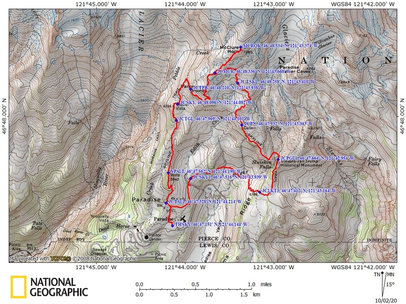
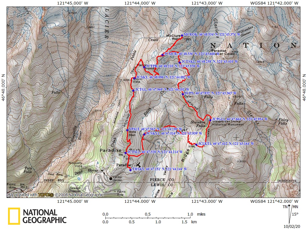
Trail Maps:
Topo Map, National Park Service Map, Download Garmin .gpx file
Review: October 27, 2008, October 10, 2020
Go to the stairs just behind the new Jackson Memorial Visitors Center. You can read a quote from John Muir inscribed on the stairs as you climb the stairs. To hike the Skyline Trail clockwise, continue up the hill towards Mt. Rainier and climb rather steeply past several trail junctions.
The trail climbs a couple of hundred feet in elevation and reaches the junction of the Alta Vista Trail in about 0.25 mile. Turn right onto the Alta Vista Trail and climb steeply up to a nice viewpoint into the the head of Paradise Valley. The small lake below is the water supply for the buildings in Paradise.
Continue over the top of Alta Vista and drop down about 100 feet to the Skyline Trail. The first mile or so of the trail has several benches or rocks sit on and rest or enjoy the views. As you get higher, the Tatoosh Range and Goat Rocks comes into view.
In about 1.1 miles you come to the junction for Glacier Vista Trail. Turn left here at waypoint JCGLV, 46° 47.969’ N, 121° 44.101’ W, and walk a short way to Glacier Vista. Glacier Vista provides a great view of the snout of the Nisqually Glacier. You can see the lower parts of the glaciers are covered with rocks and dirt that have fallen from the mountainside while the glacier slid downhill. The layer of debris consolidates as the intermixed ice melts and the layer of dirt and rocks insulate the ice from atmospheric warmth.
At Glacier Vista you can see crevasses in the Nisqually Glacier that are created when the glacier slides over the rock of Mt. Rainier. On the other side of the Nisqually Glacier you can see a tall waterfall and layers of ash and rock that were deposited as the mountain grew.
After climbing to about 6,600 feet, the trail levels off and passes a junction for the Pebble Creek Trail and Camp Muir. This unmaintained trail leads to the Muir Snowfield and Camp Muir. Don’t hike this trail unless you are prepared for cold winds and whiteout conditions. People in all seasons have been caught in a sudden change of weather and died on this steep trail to Camp Muir.
Stay on this fairly level portion of the Skyline trail as it leads up to Panorama Point in about .3 mile. Just before reaching Panorama Point, the trail climbs up a long set of stairs and erosion boards and comes a junction for Panorama Point and the Upper Skyline Trail.
Panorama Point is to the right and there are stone benches where you can sit, have a snack, some water, and drink in the views. On a clear day the views are superb. You can see the snow-capped Goat Rocks, Mt. Adams, Mt. Hood, Mt. St. Helens, and of course Mt. Rainier.
Nearby is a stone outhouse that was renovated in 2007. From Panorama Point, you usually have to take the Upper Skyline Trail because drifted snow usually blocks the lower trail until late in the season. The trail climbs a few hundred feet and .3 mile passing a second junction with the Pebble Creek Trail and then to the junction for an unmaintained trail to McClure Rock. Turn left onto the trail for McClure Rock and continue uphill, paying attention to your route for the return trip, for about 0.4 mile to reach the highest point of this trip at 7,359 feet.
Back at the junction at the Upper Skyline Trail, turn left and drop down over the top to a short level section, then start descending through the treeless landscape.
In about .25 mile is the junction with the Skyline Trail on the right. Continue along the Skyline Trail, slightly uphill, then fairly steeply downhill to the about a .75 junction with the Golden Gate Trail. The Golden Gate Trail is a shorter, but steeper return back to the parking lot. Look around for approaching rain or thunderstorms because you may want to take the shorter route to the parking lot if bad weather is approaching.
Otherwise, continue straight ahead on the Skyline Trail. Just ahead is a stream with an overlook about 50 feet past the stream. This is a raging waterfall in the spring but only a tiny trickle in the fall.
The trail follows a little ridge then drops into a small valley, crosses a stream on a wood bridge, crosses other small streams, then climbs up the a small slope to follow another ridge. This is one of my favorite parts of the trail because it looks like you’re walking right underneath Mt. Rainier.
After another .75 mile is the junction with the Paradise Glacier Trail, waypoint JCPG, and in about 500 feet later, the Stevens-Van Trump Memorial. The stone bench memorial marks the camp from where Hazard Stevens and P.B. Van Trump made the ascent of this mountain 17th of August, 1870. The Sluiskin Indian guide waited here until they returned.
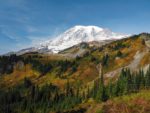
From here the trail descends off the ridge, crosses a meadow, and meets the junction of Lakes High Trail. Paradise is 1.4 miles farther along the Skyline Trail. Continue strait ahead as the trail drops down into the head of Paradise Valley. There are terrific views of Mt. Rainier along this section of the trail and there are a couple of small creeks. After that, the trail climbs back up towards the parking lot. I think this section of the trail has some of the finest fall colors in the park.
The trail then climbs slightly over Edith Creek. Just after Edith Creek is a short trail, on the left to the final highlight of this trail. It is a viewpoint of Myrtle Falls and the bridge over Edith Creek. From here the trail is paved and descends back down to the Jackson Memorial Visitors Center.
This is one of my favorite fall hikes in the park. I like to hike it clockwise because the trail heads straight towards Mt. Rainier right away.
Enjoy the Photos!
Gallery Pics
Switchback Steve