Sleeping Beauty, WA
Vicinity: 63 miles northeast of Portland in the Gifford Pinchot National Forest
Directions:
From Portland take I-84 east to Hood River. Take Exit 64 for Highway 35, White Salmon, and Government Camp.
At the traffic light turn left on Button Bridge Road for Bingen and White Salmon, pay the $3.50 toll, and drive 1.1 miles over the Hood River Bridge.
Turn left onto Highway 14W and drive 1.6 miles.
Then turn right onto Highway 141 Alt for Trout Lake and the Mt. Adams Recreation Area.
Drive next to the White Salmon River for 2.2 miles and turn left at the “Y” junction onto Highway 141 for BZ Corner, Trout Lake, and Glenwood.
From Trout Lake, Washington take State Highway 141 West to Forest Road 88 to 8810. On the unsigned FR8810 cross the creek on the first bridge and in a few hundred feet there is a sign that points to the left for Sleeping Beauty Trailhead. Continue left on FR8810. After 6.2 miles turn right to 8810-040 to the trailhead. There should be a brown sign pointing out where to turn.
Drive approximately 0.25 mile down a bumpy road to a parking area for Sleeping Beauty Trail #37 and the trailhead is on the north side of Road
No permits needed to park.
No bathrooms at the trailhead.
Length and Elevation:
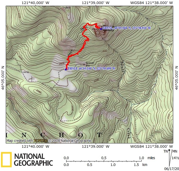
2.8 miles roundtrip. Elevation at the trailhead is 3,540 ft. Highest Point on the trail is 4,900 ft. There is 1,370 ft elevation gain and 1,370 feet elevation loss round trip.
Trails:
Sleeping Beauty Trail #37
There are no geocaches on this trail.
Trail Maps:
Topo Map, Download Garmin .gpx file, Open Garmin .gpx file
Review: June 2, 2020
Climb up through a forest of Douglas fir and grand fir with an understory of vine maples. The trail climbs the entire time up to Sleeping Beauty peak. The hike is pretty much a grind up numerous switchbacks through a second growth forest.
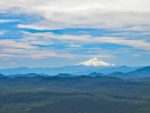
Near the top the trees thin out and you climb a few final switchbacks which were constructed by volunteers by stacking the flat basalt rocks to create nice switchbacks. Once you get to the top there are several places with 360 degree vistas. On a clear day you have nice views of Mt. St. Helens, Mt. Rainier, Mt. Adams, Mt. Hood. Also on the easternmost crag, just below the top, on the northeast corner near the top is a grave marker.
Keep an eye out for mountain goats along the cliffs by the summit. There are a couple of summits at nearly the same elevation. On the western crag is the remains of the old fire lookout. There is a pair of rockbolts sticking out that were probably used to haul supplies up a cliff to the lookout.
This is an out and back hike so once you’re done exploring the crags on the peak return back the same way to the trailhead.
Since this is a short hike you could combine it with the nearby Weldon Wagon Road hike.
Enjoy the photos!!
Gallery Pics
Switchback Steve