Stevens Creek Trail, WA
Vicinity Location:
About 69 miles southeast of Seattle, WA in Mt. Rainier National Park.
Directions:
From Seattle: Follow I-5 South for 25 miles and take exit 142A to merge onto WA Highway 18 East toward North Bend/Auburn. Drive 4.4 miles and take the Auburn Way/WA Highway 164 East exit toward Enumclaw for 0.2 mile.
From Enumclaw, drive about 47 miles on Hwy 410 and continue south onto Hwy 123. In about 6 miles turn right and drive about 4 miles and take the first left after the tunnel, into the parking area.
From Portland: Take I-5 North towards Seattle and drive for about 75 miles.
Take exit 68 for US-12 East. At the top of the off ramp, turn right onto US-12 and travel about 71.8 miles. This takes you past Morton and through Packwood. From Packwood, drive about 8 miles and turn north at the junction for Highway 123. Drive about 6 miles, past the Ohanapecosh Campground and turn left on Stevens Canyon Road. Drive about 4 miles and take the first left after the tunnel, into the parking area.
There are bathrooms and water at the trailhead.
Pets are not allowed on the trails in National Parks.
A permit is needed to park.
Trail:
Stevens Creek Trail, Box Canyon Trail, Wonderland Trail.
Trail Maps:
Topo Map, National Park Map, Download Garmin .gpx file
Length and Elevation:
2.7 miles round trip. Elevation gain of 650 feet and loss of 650 feet. Elevation at the trailhead at 3,100 feet, highest point is at 3,100 feet. Lowest elevation is 2,565 feet.
Review: October 10, 2009.
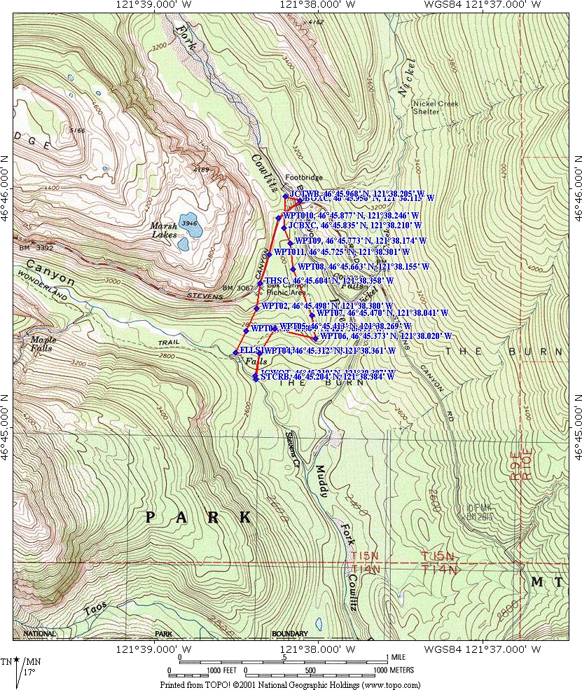
The trail starts about 200 feet east of the bathrooms at the Box Canyon Picnic Area parking lot. This trail is separate from the paved loop trail that goes around the picnic area and the restrooms.
From the trailhead, the trail drops down sharply and there are a few stairs on the first section of the trail. Walk .5 mile down to the junction and walk to the right to a viewpoint of a small waterfall on Stevens Creek. In about another .2 mile is a junction to the Wonderland Trail, and if you want to walk farther along the Wonderland Trail, Maple Creek campground is 1.7 miles away. Turn right at the junction and cross over the new bridge spanning Stevens Creek. Take in the views of the creek cutting through the bedrock and the noise of the creek.
Retrace your way back to the junction of Stevens Creek Trail and the Wonderland trail and turn right to follow the Wonderland Trail to Box Canyon. The trail has a novel road crossing here. It passes over a tunnel for the road.
The trail drops down a bit and intersects the Box Canyon Trail. Box canyon is an interesting geologic feature in that it is a narrow 180 foot deep slot canyon. Turn left here and walk upstream a few hundred feet to a wood-deck bridge over Box Canyon. The glacial stream below is the Muddy Fork of the Cowlitz River.The canyon is so narrow and deep you can barely see the creek. On a clear day there are nice views of Mt. Rainier after crossing the creek.
Continue along the trail back to the Stevens Canyon Highway. From Box Canyon it is just a short walk back to the Steven’s Creek Trail. Turn right and follow the road west about .4 mile back to the trailhead.This is a great trail for children. In the late summer, the trail sports many different kinds of fungi. Some of the colonies are quite large. There is a bit of a gravel shoulder to walk on back to the trailhead.
Enjoy the Photos!
Gallery Pics
Switchback Steve