Tilikum Crossing, OR
Directions:
Mass Transit –
Using the Portland MAX, take Orange line to the MAX Stop OMSI/SE Water
Stop ID 13727 Westbound
Stop ID 13712 Eastbound
Driving and Parking –
Weekdays:
Nearly all weekday parking in the area requires a payment to park. On weekdays, parking garages near in downtown Portland may be the best choice.
On weekdays you may find some 2 hour parking at Southeast Caruthers Street next to the Portland Opera building.
Weekends:
Traveling southbound on I-5, take exit 300B and follow the brown signs towards OMSI. Follow signs for US-26 and merge onto SE Martin Luther King Jr Blvd. Turn right at SE Salmon St then in .2 mile turn left at SE Water Avenue. In 0.2 mile you will pass the intersection of SE Clay St and SE Water Ave. Turn left into the PCC CLIMB parking.
Traveling I-5 northbound, while driving over the Marquam Bridge, take exit 300 to I-84 East towards the Portland Airport and the Dalles. Bear right onto the off-ramp for OMSI/Central Eastside Industrial District. Turn right at SE Water Avenue. In 0.3 mile you will pass the intersection of SE Clay St and SE Water Ave. Turn left into the PCC CLIMB parking.
Free parking on weekends is available along the streets in the area of PCC CLIMB.
Once you have parked, walk towards the river, then to the right to hook up with the Eastbank Esplanade under the Hawthorne Bridge.
Restrooms are available inside the OHSU building on SW Meade St. Restrooms are also on the west side of the Willamette river at the base of the Hawthorne Bridge in Tom McCall Waterfront Park.
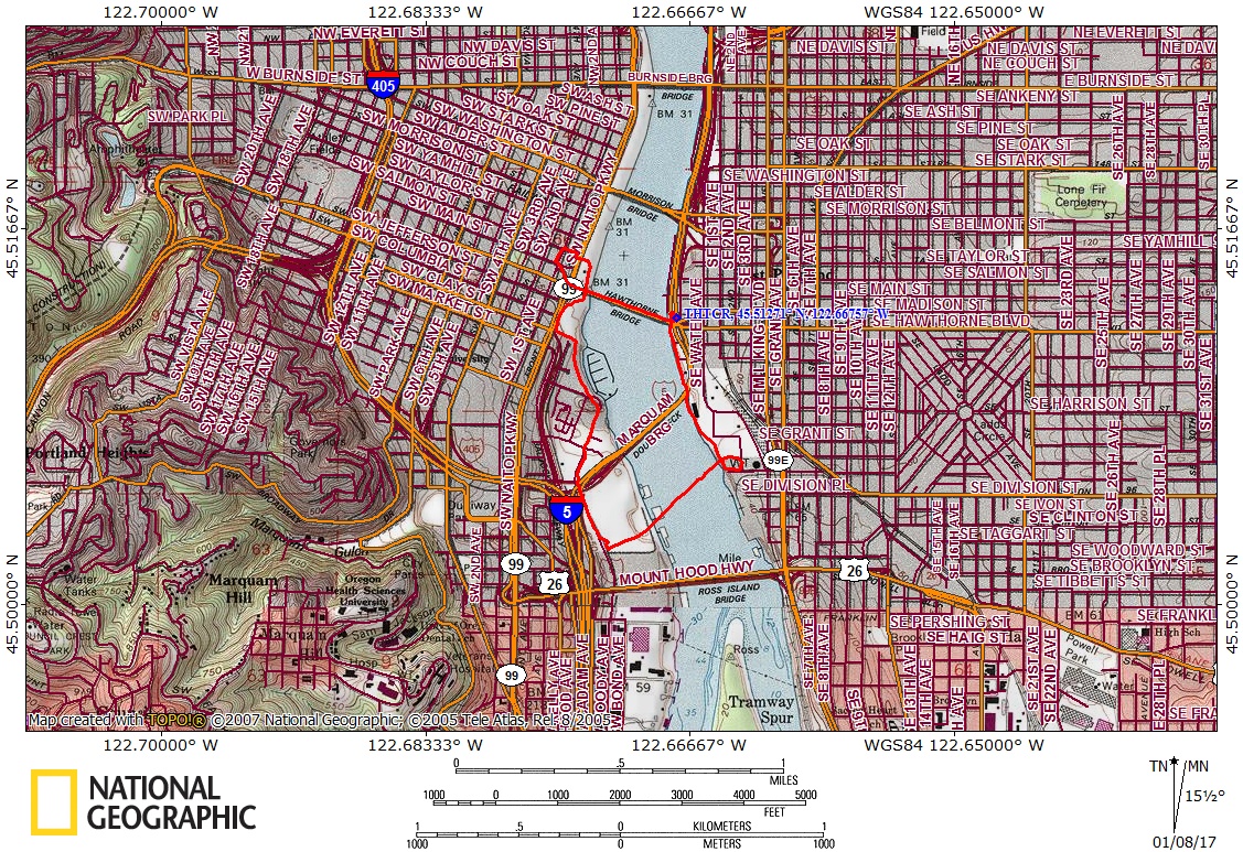
Length and Elevation:
2.75 Miles, Elevation gain 70 feet. Total gain and loss totals 140 feet. Highest elevation is 75 feet and the lowest elevation is 33 feet.
Trail:
Springwater Corridor which is part of the Portland 40 mile loop.
There is at least one geocache along this trail at: N 45° 31.064 W 122° 40.406 Info at Geocaching.com
Trail Maps:
Topo Map, Portland 40 mile Loop, Springwater Corridor and Eastbank Esplanade, Download Garmin .gpx file
Review: January 6, 2017.
From OMSI, go along the riverfront, passing underneath Hawthorne Bridge, and taking the sidewalk. Loop up to the bridge deck, turn right, and walk over the Hawthorne Bridge. In the summer you are about 50 feet above the water. Enjoy the nice views Portland and the Willamette River along with the other pedestrians and 8,000 bicycles that use the bridge each day. At the far end of the bridge follow the curved sidewalk around as it drops back down to the riverfront walkway.
As you continue along the waterfront you will pass back underneath the Hawthorne Bridge, which opened in 1910. The two tall green steel towers on either side of the drawbridge are 165 feet tall. Next you go along the end of Waterfront Park, skirting a large grassy area where summertime concerts are held such as the Waterfront Blues Festival.
Follow the sidewalk back to the riverfront passing the River Place Hotel and several shops with plenty of places to sit and take in the view. Pass a small boat moorage as you go along the waterfront and continue along next to the buildings which will lead away from the river a bit. Cross Southwest River Parkway, turn right, go one block, and turn left on Southwest Moody Ave.
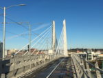
Pass the Residence Inn by Marriott and then underneath the double deck of the Marquam Bridge high above. Just a bit farther is the approach to Tilikum Crossing. Use a crosswalk to go over the tracks and walk over the bridge.
At the end of the talking Crossing turn right on South East 2nd Place and loop around the Portland Opera building, returning to the riverfront. Complete your loop, going past the USS Blueback, moored in the Willamette, and OMSI.
This is a great trail for children as you can turn around at any time, the trails are fairly wide, and there are shops where you can get a snack.
Enjoy the photos!!
Gallery Pics
Switchback Steve