Timberline Trail – Paradise, OR
Notice: 10/6/2020 – Many blowdowns in the second mile from Hidden Lake junction to Zigzag Canyon overlook.
Vicinity Location:
The trailhead is about 49 miles southeast of Portland, Oregon in the Mt. Hood National Forest
Directions:
From Portland take I-84 East to the Wood Village, exit (16A). Head south and turn left onto NE Burnside Rd. Heading East, Burnside will merge into Highway 26. Follow Hwy 26 to Government Camp. Turn left onto the road to Timberline Lodge.
In winter, it is required to carry chains or have traction devices. The road to Timberline requires chains during much of the winter.
A wilderness permit is required. The free self-registration for a wilderness permit is about a mile north of Timberline Lodge, along the trail.
Bathrooms are available at the Wy’East Day Lodge or at Timberline Lodge.
Permits are required to park here seasonally. No parking permit is needed during the summer. A Sno-Park permit is required to park in the winter (Nov. 1st -thru- Apr. 30th).
Length and Elevation:
11 miles, Elevation gain 1,380 feet and loss 1,565 feet to Lost Creek. Gain of 1,660 and loss of 1,480 to the start of Mississippi Head, above Paradise. Total gain and loss is 2,945 feet to Lost Creek. Trailhead elevation is 5,940 feet, Paradise is at 5,600 feet.
Trail:
Timberline Trail #600 and overlapping with the Pacific Crest Trail #2000, Paradise Park Trail #778, Paradise Loop Trail #757, with connections to the Mountaineer Trail #798.
There are no geocaches along these trails.
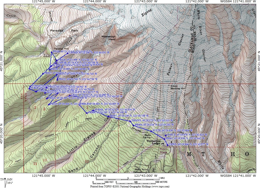
Trail Maps:
Topo Map, Download Garmin .gpx file
Review: September 17 & 20, 2011
There are a couple of places to access the trail. A couple of hundred feet south (to the right) of the lodge is a set of stairs leading up from the parking lot which lead up to a short path to a paved service road. Follow the service road about 500 feet up to the Pacific Crest Trail and turn left onto the trail.
The trail goes along the side of the mountain passing underneath some chairlifts to the wilderness boundary. At the boundary fill out the wilderness permit and drop a copy in the box and put the other copy on your pack. In about .25 mile you take a switchback down to a creek that may be dry on cloudy days and flowing on sunny days. From the creek, climb back up on the shoulder of Mt. Hood and continue along the generally descending trail clockwise around the mountain.
In just under a mile the trail passes the junction for the Mountaineer Trail on the right and in a short distance is where the old Timberline Cabin, built in 1916, once stood, on the left. Only the parts of the foundation and chimney remain.
About 1.75 miles from the trailhead the trail crosses the normally dry valley but looking farther down the valley there is a spring with a creek bursting out of the ground.
About .25 more miles farther along is a nice viewpoint looking into Zigzag Canyon and up towards Mt. Hood. From the viewpoint follow the trail down along the top ridge of the valley back into the forest and through a series of switchbacks, passing trickles and small streams dropping down to the Zigzag River crossing at the bottom.
Usually this crossing is a step across but sunny days or heavy rains could make this a wading crossing. On rare occasions the stream is not safe to cross and you will have to wait for the water to go down. Crossing Zigzag River, look about 400 feet upstream to where the river plunges over a waterfall. You can negotiate the rocks along the bank for a closer look.
After climbing for about .5 mile from ZigZag River there is a trail junction. To the right is part of the Paradise Loop and straight ahead is the Pacific Crest Trail. Follow the Pacific Crest trail uphill.
At about 4.5 miles you come to an unsigned junction to the right. There is a viewpoint off to the left. Continue to the right for about 200 feet, dropping down a bit to the signed junction for the Paradise Park Trail 778. Follow the trail to the right uphill through meadows of flowers in the summer.
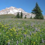
The trail climbs about .5 mile and intersects with the Paradise Loop Trail 757. From here you can continue straight up and wander around in the paradise area. The smell of a meadow full of lupines in bloom is an amazing perfume smell. You don’t notice the smell of one lupine but a meadow of thousands fills the air with their sweet scent.
From the junction of trails 778 and 757, head north, slightly uphill on the Paradise Park Trail. Walk about .25 mile to a creek crossing. This is Lost Creek and it has a beautiful backdrop of Mt. Hood.
Hop across the creek and walk just a bit farther to an area where people camp. Look about for the remains of the Paradise shelter. All that is left is a bit of the stone foundation.
Coming back, walk south on the trail and go straight when you get back to the junction of trails 778 and 757. This takes you down the Paradise Loop Trail #757. The trail drops quickly out of Paradise with a few last looks at Mt. Hood as the trail winds down past a small ravine and continues to lose elevation at a moderate rate.
The next junction reached is the Pacific Crest Trail. Turn left, back towards Timberline Lodge and continue down the switchbacks towards Zigzag Creek. As you come down into Zigzag Canyon the trail drops down a couple of switchbacks. Look for a short viewpoint trail after one of the switchbacks. The trail leads to a nice view into Zigzag Canyon.
When the wildflowers are at their peak, this is a “must” hike. This hike is great for older children because of the length of the hike and total elevation gain to Mississippi Head. There are some very steep drop offs along the trail going down into Zigzag canyon but no sheer cliffs.
Enjoy the photos!!
Gallery Pics
Switchback Steve