Tom McCall Nature Preserve, OR
Note: Tom McCall Point Trail is open March 1-October 31st annually and closed November through February to control trail erosion.
Vicinity Location: 67 miles east of Portland, Oregon in the Columbia River National Scenic Area.
Directions:
From Portland, Oregon, take I-84 east for about 70 miles, driving past Hood River, and take exit #69 for Mosier.
Drive east on the Columbia River Scenic Highway for 6.5 miles to the Rowena Crest Viewpoint.
To return to Portland, continue east on the Columbia River Scenic Highway for 5 miles as it winds down to I-84 at exit #76. Go under the freeway and turn left to merge onto I-84 West.
No permits are needed to park at the trailhead.
No restroom facilities or drinking water is available at the trailhead. The easiest location for water and bathrooms are at the freeway rest area at milepost 73 of I-84 westbound. The next closest is Mayer State Park near exit #76 of I-84. The State Park is a day use area open from 8am to 10pm and may require a $3 Oregon State Park day use fee.
No bicycles, dogs or horses are allowed on these trails. No hunting or camping is allowed.
Length and Elevation:
6.2 miles roundtrip. Lower trail 2.2 miles roundtrip. Upper trail 4 miles roundtrip.
Trailhead elevation: 700 feet.
Rowena Plateau Trail: 170 feet gain, 170 feet loss. Highest point 700 feet.
Tom McCall Point Trail: 1,150 feet gain, 1,150 feet loss. Highest point 1,850 feet.
Trail:
Rowena Plateau Trail and Tom McCall Point Trail.
There is at least one geocache along this trail at: N 45° 40.960 W 121° 18.024. Info at Geocaching.com
Trail Maps:
Topo Map
Review: May 9, 2009
The parking lot commands a nice view of the Columbia River Gorge and there is no shade at or near the parking lot. The sun shines a lot in the Gorge and will quickly make your car like a hot oven on most days.
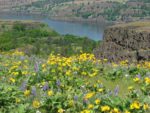
Some of the best wildflower views of the plateau are along the road looking towards the Columbia River Gorge. The Rowena Plateau Trail begins just west of the Columbia River Scenic Highway and descends gently along a basalt gravel and packed dirt trail. There are a couple of side trails leading off to the right leading to overlooks into the Gorge.
In late April through mid-May the Balsamroot, Fool’s Onion, Lupines, along with many smaller wildflowers bloom profusely and put on the main show of spring flowers. The trail continues across the plateau and passes a couple more side-trails going to views of the gorge to the right.
Red-winged blackbird, Turkey Vultures, and other birds frequent this area and provide good bird-watching opportunities. This seems to be a popular place for Turkey Vultures with the wind hitting the cliffs and making updrafts for the vultures to soar lazily through the air looking for a meal.
Continuing down the trail leads alongside the first of two ponds. The pond is ringed with poison oak but has a narrow path leading to the pond. There are cattails and lily pads in the pond and willows ringing the shoreline provide shelter for birds and other wildlife.
The second pond is much smaller than the first pond and there isn’t a good trail to the edge of the pond. Continue past the second pond and downslope to the edge of the cliffs and unobstructed views into the Gorge. This is the turnaround point and from here, retrace your steps back up to the sign for Rowena Crest. From here, you can call it a hike or you can hike on the Tom McCall Point trail.
The Tom McCall Point trail crosses a large flower-strewn meadow with beautiful views of the Gorge and starts climbing up to the point after about .5 mile. Just before the trail starts to climb is a side trail to the right. This trail isn’t expecially scenic and just leads out to the highway. The trail goes along the edge of the cliff, turns gently to the left and starts to climb gently towards the ridge. There are fields of Balsamroot in the distance and poison oak along the trail.
The trail soon starts switchbacking up the ridge through scrubby oak trees, past fields of flowers, panoramic views of the Gorge. The trail leads to an open vista of Mt. Hood and the Columbia River Gorge.
There is an additional segment of the trail that leads down the far side of Tom McCall point, and back up a slope to the Columbia Plateau. The trail goes right along the top edge of the Gorge, sometimes dipping down a bit and sometimes on top of the plateau. On the plateau the trail winds in and out patches of Indian Paintbrush, lupines, scrub oaks, Goldenrod, and a few pine trees to pleasantly scent the air. There are several viewpoints into the Gorge along the way. The trail ends at a gate leading to a farm on private property.
Remember not to pick up any insect hitchhikers along the way as ticks are plentiful in this part of the Gorge.
This is a fantastic wildflower hike in early to mid-May. It is a “Must” hike during the peak season of the Balsamroot flowering. There are some 100 foot cliffs along the trails, so hikers must know their limits and stay back from cliff edges.
Enjoy the photos!!
Gallery Pics
Switchback Steve