Towell Falls, WA
Vicinity Location:
The trailhead is 210 miles southeast of Seattle, WA and 245 northeast of Portland, OR
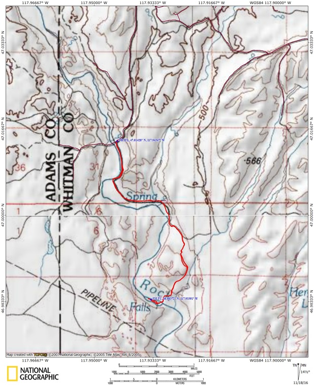
Directions: Note that cell phone reception can be poor to non-existent all around this area. From Sprague, exit 245. Turn onto Highway 23, traveling south for 12.2 miles to Davis Rd. Turn right onto Davis Rd., at 4 miles there is a “Y”, stay to the right continuing south for 3 miles to Jordan Knott Rd. Turn left onto Jordan Knott Rd. and travel for 2.2 miles to the Rock Creek BLM public land access (.8 mile past Breeden Rd). Follow the BLM access road until it ends in 2.4 miles.
From the south: From Endicott W Road, Turn right onto Jordan-Knott Rd. at 6.5 miles bear left to stay on Jordan-Knott Rd. At 11.6 miles turn left onto unmarked road and go over a cattle guard. There is a sign for Rock Creek Management Area. Follow the BLM access road until it ends at the horse campground in 2.4 miles.
No permits are needed to park.
There is a bathroom at the trailhead.
Trail:
No named trails
There is a geocache at: N 46° 59.051 W 117° 55.917 Info at Geocaching.com
Length and Elevation:
Total distance is 6.75 miles roundtrip. Trailhead elevation is 1,457 feet. Highest point is 1,600 feet. Lowest point is 1,385 feet.
Total elevation change is 600 feet up and 600 feet down.
Trail Maps:
Topo Map, BLM Map, Download Garmin .gpx file
Review: May 11, 2015
The hike follows an old road for most of the way out, then a trail leads over to the falls. Walking through the scablands you pass fine examples of what scablands are. You can wander off and investigate interesting geologic features and perspectives.
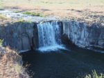
When you get close to the falls, you have to cross a creek to get onto the island where the falls are best shot. The big falls are located on the southwest end of the island. The banks are rather overgrown, so you have to fight your way to an some of the better areas to photograph the falls. The upper falls are easy to view because they are in the open and fall from ground level down. Though the main falls are only 14 feet high, they are very picturesque. There are two other small falls, but their flow is reliant on creek flow levels. There were Killdeers nesting near the falls so be careful not to disturb the nests.
This is a popular area for horse riding and there is a horse camp adjoining the parking area. There is also room for tent camping. Don’t expect to see many people because the area is uncrowded due to the rural character of the region.
The road to Towell Falls is open during spring but it is so narrow and rutted that it is best to walk or use a mountain bike. This trail is not suitable for small children and dogs due to rattlesnakes in the area.
Enjoy the photos!!
Gallery Pics
Switchback Steve