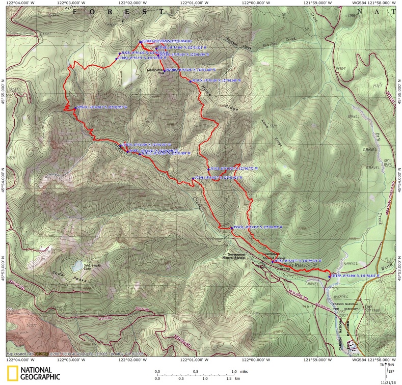
Trapper Creek Loop, WA
Vicinity Location:
The trailhead is about 42 miles northeast of Portland, Oregon in the Gifford Pinchot National Forest.
Directions:
From Portland, Oregon, there are two ways to drive to the trailhead. If you have an extra 30 minutes then make your trip a loop drive.
For the loop drive, take I-205 north across the Columbia River. Exit I-205 on Highway 14 east for about 28 miles through the town of Stevenson.
For the non-loop option, take I-84 east from Portland and take exit #44 for Cascade Locks.
Take the first right turn, just after you go under the Bridge of the Gods. Pay the $3.00 toll, cross the bridge, and turn right onto Highway 14 and drive 2.5 miles to Stevenson.
Once you get to Stevenson, drive about 2 more miles east to Wind River Road. Wind River Road is 5.9 miles east of the Bridge of the Gods.
Drive on the Wind River Road north for about 13.4 miles until about 0.25 mile past the Carson National Fish Hatchery. Take a left on Mineral Springs Road (Forest Road 3065) and drive for 0.5 mile.
Take the first right on Forest Road 5401 and drive about 0.3 mile to the parking area and trailhead.
There is an outhouse at the trailhead.
A Northwest Forest Park permit is required at the trailhead.
Length and Elevation:
To Observation Peak: Length 8.6 miles, total ascent 3,446 feet, descent 432 feet.
Total: Length 15.1 miles, total ascent 5,362 feet, total descent 5,362 feet. Lowest elevation: 1,182 feet. Highest elevation: 4,206 feet.
Trail:
Trapper Creek Trail #192, Trapper Creek-Shortcut #129B, Observation Peak Trail #132A, Observation Trail #132 with connections to: Deer Cutoff Primitive Trail #209, Dry Creek Trail #194, Rim Primitive Trail #202, Soda Peaks Lake Trail #133, Sunshine Primitive Trail #198, Trapper Creek Trail #192.1, and Trapper Creek Trail #192.2
There are no known geocaches along this trail at the time of this review.
Trail Maps:
National Forest Service Map, Topo Map, Download Garmin .gpx file
Review: November 11, 2018
From the parking lot walk a short distance from the information board on Trapper Creek Trail #192 to the Wilderness Registration box and fill out the form if there is one available. Turn left at the junction of the Trapper Creek and Dry Creek Trail and walk through a flat forested area with fir, hemlock, and maples overhead.
After about .5 mile you reach a junction with Trail 182. Note that this is your return trail so you don’t turn the wrong way and reach a different parking lot on your way back.
Continue along a mostly level path to a junction at a creek that is dry in the summer. Continue straight at this four-way junction with Trapper Creek and Observation Trails. From here climb gently farther away from Trapper Creek. Stay on Trapper Creek Trail #192 as you pass a few junctions for primitive trails. Pass by several huge Douglas fir trees as you gain and lose elevation along the narrow trail crossing several seasonal and year-round creeks.
After 2.65 miles, pass two primitive trail junctions, Trapper Creek-Big Slide Trail Junction and about 150 feet further, the Trapper Creek-Deer Cutoff Trail East Junction. Stay on trail 192 and head downhill winding past several giant deadfalls and to parallel Trapper Creek. In about .8 mile you climb uphill and pass the west end of the Trapper Creek-Deer Cutoff Junction. In about .2 mile pass by the junction to the Trapper Creek-Sunshine Trail Junction.
In about another .1 mile drop down a bit and rock hop over Hidden Creek, passing the bridge that now uselessly points downstream and rests near the bank. After crossing ascend for about 0.1 mile and reach a campsite. There is a user trail that heads up the ridge. You can follow this for about 0.15 mile through several areas of deadfalls to a partially obscured view of Hidden Creek Falls. It isn’t much of a reward for the view but if you’re up for a bit of bushwhacking, it is a nice view across the narrow valley. For about the next .5 mile the forested trail ascends, levels off, and then drops down and crosses Trapper Creek. There are occasional views of Soda Peaks across Trapper Creek valley. Getting further into the wilderness means there is less trail maintenance. The tread becomes narrower, rootier, and has a less consistent grade as it negotiates trees and rocks.
There is a great place for a little break once you get to where a couple tributaries of Trapper Creek join together. There are some nice campsites here and easy access to the stream. From here begin a steep climb up switchbacks to a rock outcrop that provides a great view of Trapper Creek Falls across a deep valley. Trapper Creek Falls plunges about 100 feet to disappear into the forest.
From the viewpoint the trail ascends more switchbacks where recent trail work has created some stone steps in the steepest parts of the trail. The trail levels out and enters a semi-open forest of Douglas-fir, western hemlock and sliver firs. Pass by trail junctions for a primitive trail then drop gently down through a blueberry lined trail and over some spring-fed creeks. Cross over Trapper Creek, go over a small rise, and cross another small stream. Continuing up the trail you may see two trees with a small metal diamond on them. This marks another primitive trail, Trapper Creek-606 Spur Trail Junction.
Continue a short distance further and turn right on the Trapper Creek-Shortcut #129B. The trail is easy to follow as it climbs up to the trail to Observation Creek Trail.
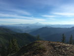
Make a right on this trail for 25 yards and then stay right and take Observation Peak Trail #132A. On the way up through the forest, there is a spur trail on the left that leads up to rock outcrop with views of Mount Rainier, Goat Rocks, Mount Adams, and across to Indian Heaven.
Walk another .3 mile heading generally south back across the saddle and up to Observation Peak. On a clear day take in great views of Mount Saint Helens, Mt. Rainier, Goat Rocks, Mt. Adams, Mt. Hood, and as far south as Mount Jefferson, as well as a territorial view of the Trapper Creek drainage.
From the summit, head back down the trail about .5 mile and turn right at the junction for Observation Trail #132 (this trail was unsigned at the time of this review). Traverse a level section beneath Observation Peak then start descending along a ridge crest and drop down along Howe Ridge.
This section of trail is nicely graded and your footsteps fall softly on the carpet of fir needles and fallen leaves. Pass the Observation-Sunshine Trail Junction and continue down along Howe Ridge. There are more old-growth Douglas firs and one was the biggest one on the whole hike. Look for a last view of Soda Peaks across the Trapper Creek valley then descend through a forest with a mix of firs and maples. Continue past the Observation-Big Slide Trail Junction and through some sections of the trail that are bordered with vanilla leaf.
Cross a creek with a camp site dug into the hill just above the trail. The trail drops gradually, winding in and out of small gullies then crosses Howe Creek. The trail continues down to the Trapper Creek-Observation Trail Junction you passed early in the day. Turn left and walk the level trail for .9 mile back to the parking lot, remembering to turn right at the junction for Dry Creek Trail #194.
This trail passes through the largest stand of lowland old-growth forest remaining in southern Washington. Most of this area has never been logged and contain huge Douglas firs scattered along the route. Don’t underestimate that there is over a mile of elevation gain for this hike.
Enjoy the photos!!
Gallery Pics
Switchback Steve