Trillium Lake, OR
Vicinity Location:
The trailhead is about 49 miles southeast of Portland, Oregon in the Mt. Hood National Forest.
Directions:
From Portland take I-84 East to the Wood Village, exit (16A). Head south and turn left onto NE Burnside Rd. Heading East, Burnside will merge into Highway 26. Follow Hwy 26 for 41 miles, about 1.7 miles past Government Camp and turn right into the Sno-park for Trillium Lake. This is also the junction of Hwy 26 and Forest Road 2656.
In winter, it is required to carry chains or have traction devices. The parking lot is on a downward slope and not having chains could leave you stuck in the parking lot.
This is a very popular location and the parking lot overflows on nice weekends.
There are no restrooms at the trailhead. Bathrooms are available 1.7 miles west at Government Camp.
A metal donation box is at the start of the trail off to the right and is for donations to groom and maintain the trail. A $3 donation is requested for this trail.
Weekend grooming is done by a volunteer group with the donated dollars. The money goes solely for the rental of the grooming equipment.
A current Sno-Park permit is required to be displayed between November 1 and April 30. Oregon permits cost $4 a day, $9 for three days or $25 for the season. The permits can be bought on-line, in Government Camp other outdoor stores or DMV offices.
National Weather Service Snow Level forecast: Northern Oregon Cascades
Length and Elevation:
4.5 miles roundtrip, Elevation loss of 230 feet to the outlet of Trillium Lake. Elevation gain of 300 feet and loss of 300 feet roundtrip. Elevation at the trailhead at 3,830 feet, highest point is at 3,830 feet. Lowest elevation is 3,600 feet.
Trail:
Trillium Lake Trail and Red Top Meadows Trail. Connections to Mud Creek Loop, and other un-plowed Forest Service Roads.
Trail Maps:
Topo Map, Download Garmin .gpx file
Review: April 10, 2010
From the trailhead, make your way down the hill. If you are on skis, you will find the almost .5 mile slope is a little steep to ski. Ski in the snow along the edges of the road to slow your descent or walk down the hill.
The trail follows Forest Service Road 2656 and levels out at the bottom of the hill, then crosses a small mountain stream. Pause here for a moment at the stream and listen to the sounds of the water on a winter day.
The first trail junction appears shortly after crossing over the stream where you make a left, following the trail along the Forest Road. The trail gently slopes up and down. There is no avalanche danger along this trail.
After climbing a slight incline, there is a nice gradual descent down to the Trillium Lake Campground. Stay left, following the Forest Service Road.
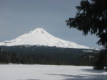
There are several junctions along this trail. The next junction on the left is for the Mud Lake Loop. For this trip, continue straight ahead, continuing to go around Trillium Lake. The trail curves gently to the right and drops slightly downhill and the road crosses over the outlet to the lake. There are fine views of Mt. Hood on a clear day and you can walk along the snow-covered shore of Trillium Lake for better views.
The trail re-enters the forest and climbs ever so gently, winding through the woods, to a junction with Sherar Burn Road, then drops down again and passes by the north end of the lake. The trail passes by some cabins, and turn right at the power line. This is East Perry Vickars Road. From here there are views of Mt. Hood rising above the Douglas Fir trees.
Just down the road a bit is a sign for Summit Prairie and it tells of the pioneer settlers stopping here to get grass for their cattle before they had to go over Laurel Hill. The road parallels Summit Prairie and provides nice views of Mt. Hood.
Just after the main split in the trail, on the east side of the stream is a junction for Red Top Meadows Trail. Turn right at waypoint JRDT and cross the meadow. The Red Top Meadows trail is a little less steep than following the Forest Service Road back to the parking lot. This route is less used than the Forest Service Road and has some brush along it. When the trail nears Highway 26 and the road noise becomes easily discernable, look for a little trail to your left. The trail almost doubles back in a switchback, goes uphill, and back to the parking lot.
This trail is a great choice for kids learning to ski or snowshoe. It is a very popular trail and receives heavy use. There are no drop-offs worry about and the trail is very popular. This trail is a good choice for a windy day because most of the trail is sheltered in the trees and down in a depression. So if the east wind is blowing 20 or 30 miles per hour at some locations, try Trillium Lake.
Enjoy the photos!!
Gallery Pics
Switchback Steve