Umtanum Creek, WA
Note: The trail is closed at mile 3.25 seasonally from February 1st to July 15th to protect wildlife.
Vicinity Location: Eastern Washington
Location: The trailhead is 100 miles southeast of Seattle and 140 miles northeast of Portland.
Directions:
From I-90, take exit 110. Continue east on I-82 about 3.5 miles to Exit 3 for Thrall Road. At the stop sign, turn right onto SR 821. Turn left at the next stop sign, and proceed southeast along Hwy 821 into Yakima Canyon. Continue 8 miles to the Umtanum Recreation Area. The parking lot is on the right side of the road.
A parking permit is required at this BLM site of $5 per vehicle per day. A Northwest Forest Pass and a Discover Pass are not valid here. America the Beautiful passes are valid here.
There is a bathroom at the trailhead.
Length and Elevation: Total distance is 6.5 miles. Trailhead elevation is 1,340 feet. Highest point is 1,840 feet. Lowest point is 1,340 feet.
Total elevation change is 500 feet up and 500 feet down.
Trail Maps:
Topo Map, Download Garmin .gpx file
Review: 4/18/2015
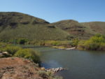
From the parking area, cross the suspension bridge over the Yakima River and follow the trail under the railroad tracks and into the canyon and enter the L.T. Murray Wildlife Area. At the first junction, continue straight ahead along the stream. Watch for bighorn sheep on the cliffs above the trail and after about 0.75 mile the trail splits, just past a boulder in a field. Take the left fork and continue along the creek. Keep an eye out for old apple and walnut trees which are about the only remnants of an old homestead.
Continue up the canyon through open fields, brush, and a dense grove of aspen. After about a mile, pass a very nice campsite in the trees. Continue along the stream with cliffs towering above. After about 3 miles the going becomes more difficult and for better views try scrambling to the top of one of the many outcroppings for sweeping views up and down the canyon. Be sure to watch any handhold for rattlesnakes. When you’re ready to head home, return the way you came.
Don’t place rocks in the stream to make it easier to cross. In 2018 there was a fish restoration project that removed a beaver dam and placed logs in the stream to enhance the creek for fish. This is an important fish habitat on the Yakima river because there are relatively few tributaries in the Yakima Valley.
This is a good trail for children as the trail rises gently along a nice creek with plenty of early season wildflowers. There are only a couple of sharp dropoffs to watch out for where the creek has eroded the banks next to the trail.
Enjoy the photos!!
Gallery Pics
Switchback Steve